

Directions
From Naches, Washington, follow U.S. Highway 12 west to State Route (SR) 410. Take SR 410 for approximately 40 miles to MP 83, where you will see an access road and gate for the site on the south side of the road.
Phone
509-653-1401
Activities
FISHING, HIKING, WILDLIFE VIEWING
Keywords
SAL1,MP83,American River Camp,OKANOGAN – WENATCHEE NF -FS
Related Link(s)
Washington State Road Conditions
Overview
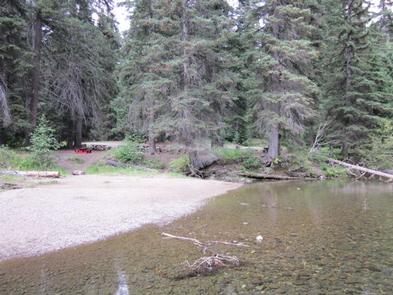
Salmon Cove Group Campground is located on the pebble-strewn bank of the American River in the Okanogan-Wenatchee National Forest, providing a nice setting for groups and larger gatherings. Visitors enjoy fishing, rafting and hiking in the surrounding area.
Recreation
Salmon Cove Group Campground offers outdoor enthusiasts the opportunity to hike, fish, ski, raft and enjoy a multitude of recreational activities throughout the year.
The American River flows next to the campground, offering a scenic backdrop for swimmers, rafters and kayakers braving its cold, refreshing waters. Anglers drop lines for rainbow and brown trout in many deep pools lining the shore.
Nearby American Ridge Trail is open to hiking, backpacking and horseback riding. The trail extends 26 miles from Bumping River to the notable Pacific Crest Trail, meandering through towering forests, stretches of meadows and past alpine lakes, offering scenic ridge line views along the way.
Facilities
Salmon Cove Group Campground contains one large site that can accommodate up to 60 people and 15 vehicles. The site is equipped with picnic tables, campfire rings and one vault toilet. No hookups or drinking water are available. Visitors can get water at nearby Hell’s Crossing Campground.
Natural Features
The Okanogan-Wenatchee is comprised of high, glaciated alpine peaks towering along the Cascade Crest, where lush valleys of old-growth forest define its western boundary. At its eastern edge, rugged shrub-steppe country comprises a more arid region. Elevations range from below 1,000 feet to over 9,000 feet. Precipitation varies greatly throughout the area, ranging from approximately 140 inches along the Cascade Crest to only 10 inches along the eastern edge. Visitors can expect many days of warm, sunny weather in the summer, and plenty of snow in the winter. The area supports wildlife such as deer, porcupine, native fish and migratory birds.
Nearby Attractions
Boulder Cave National Recreation Trail is one of the most popular places in the Naches District. Visitors can walk the accessible trail along the river or explore Boulder Cave. Interpretive signs along the trail explain the geology, plants, animals and fire history of the area. Visitors may want to take some time to visit nearby Mount Rainier National Park. This beautiful park offers fantastic glimpses of glaciers, subalpine ecology and volcanic landscapes. Visitors also enjoy traversing the Chinook Scenic Byway, considered one of Washington’s premier driving excursions. Spectacular views of Mount Rainier, old-growth forests, alpine peaks, jagged ridges and river canyons dominate this 92-mile journey.