
Directions
From Afton, Wyoming, take Highway 89 north about 31 miles to Alpine. At Alpine, turn right (south) onto Greys River Road (Forest Road 10138) and travel about 8 miles to the junction with Little Greys River Road (Forest Road 10124). Turn left (northeast) onto Little Greys River Road and drive about 11 miles to Forest Road 10047. Turn left at that junction and continue another 2 miles. At fork, turn left and follow the road to the cabin, which will be in plain view. Access is along low-speed gravel roads.
Phone
307-886-5300
Activities
BIKING, CAMPING, FISHING, HIKING, HUNTING, WILDLIFE VIEWING
Keywords
MCAN,MCCAIN,MCAIN CABIN,MCCAIN CABIN,BRIDGER-TETON NF – FS
Related Link(s)
Overview
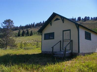
McCain Guard Station is a rustic cabin that is popular year-round. In summer, hikers and horseback riders frequent the cabin, and snowmobile enthusiasts make use of the cabin throughout the winter. Several trails are nearby, and the open meadows offer gentle sledding for younger riders. Winter access in by snowmobile only on a groomed trail.
Constructed in 1933 by the Civilian Conservation Corps (CCC), the cabin welcomes guests to experience the rustic getaway with impressive scenery.
Recreation
Numerous creeks and the Little Greys River meander through the area, offering fishing opportunities. Hiking, biking, horseback riding and off-road vehicle trails are also in the vicinity. This includes Big Springs Trail and the 9-mile Bailey Creek Trail along a portion of the designated Wild and Scenic Snake River Headwaters. Motorbikes are allowed on nearby Telephone Pass trail from 7/1-9/10.
Facilities
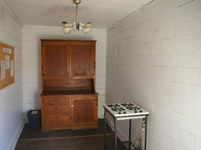
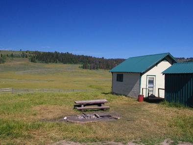
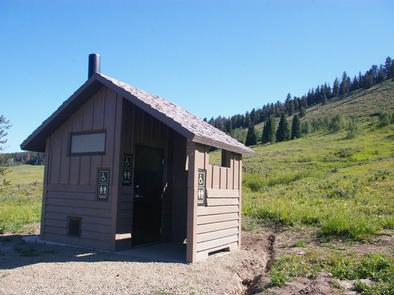
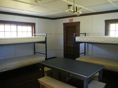
The nonelectric two-room dwelling fits six overnight guests and an additional five guests may camp outside. A vault toilet, picnic table and fire ring are located outside behind the cabin. Bunkbeds with mattresses are provided. The kitchen has basic amenities including a propane cook top, propane lighting and a table and chairs. A woodstove and propane heater are also provided, with firewood stacked for winter. No water is available, and dishes, pots, pans and utensils are not provided. Recommended items to bring include drinking water, garbage bags, dish soap, dish towels, toilet paper, a flashlight, sleeping bags and pillows and cleaning products such as bleach or disinfectant.
Natural Features
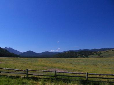
Nestled in a mountain valley at 6,900 feet in elevation, the cabin is perched near a creek that flows into Little Greys River. Pines line the hillsides, but no trees are near enough to offer natural shade to the cabin complex. Deer, moose, elk, eagles and sandhill cranes are among the wildlife likely to be seen. An abundance of wildflowers color the landscape in summer. The Bridger-Teton National Forest offers more than 3.4 million acres of public lands for outdoor recreation. With its pristine watersheds, abundant wildlife and immense wildlands, the forest comprises a large part of the Greater Yellowstone Ecosystem, the largest intact ecosystem in the lower 48 states.
Nearby Attractions
The cabin is 23 miles from Alpine, where the nearest grocery store, gas station and restaurant are located. Due to gravel mountain roads, this drive takes over an hour.