JONES CORRAL GUARD STATION, UT Campground Reservation, Info, Images, Map, Directions

JONES CORRAL GUARD STATION, Utah Campground Images, Info & Reservations

Directions

From State Highway 89, turn east onto State Highway 62 and travel about 12 miles, where it turns into State Highway 22 just north of Antimony. In this town, Forest Road 126 will be found on the west side of the road. Travel along this high-clearance dirt road about 12 miles to reach Jones Corral Guard Station.

From Bryce Canyon National Park, travel north on State Highway 22 approximately 35 miles to Antimony. In this town, Forest Service Road 126 will be found on the west side of the highway. Travel along this high-clearance dirt road about 12 miles to Jones Corral Guard Station.

Phone

435-676-9300

Activities

BIKING, CAMPING, HIKING, HORSEBACK RIDING, HUNTING, WILDLIFE VIEWING

Keywords

JOGS,DIXIE NF – FS

Related Link(s)

Rec Area Info & Images

Utah State Road Conditions

Utah State Tourism

Overview

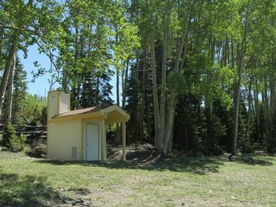
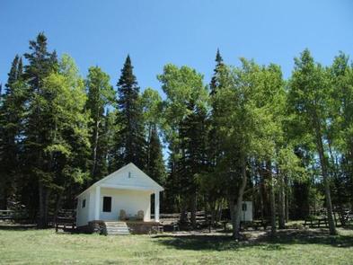
Jones Corral Guard Station is located on the Dixie National Forest, 12 miles west of the small town of Antimony, in southern Utah. It was constructed in 1935 and has been used by generations of Forest Service employees working in the surrounding back country.

The guard station provides a great base camp for hikers, hunters, bicyclists and horseback riders, as well as off-road vehicle enthusiasts.

Recreation

Recreational opportunities include hiking, mountain biking, horseback riding, hunting, wildlife viewing and exploring off-road vehicle trails. The Fremont OHV Trail can easily be accessed from the guard station. Mount Dutton is well-known for its trophy game animals.

Facilities

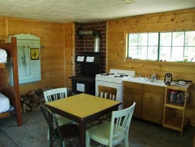
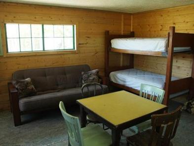
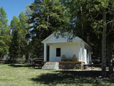
The rustic cabin can sleep four people comfortably, but up to six guests are allowed. Two sets of twin-size bunk beds and a double futon are provided. Guests must bring their own linens.

The kitchen is equipped with a propane stove and oven, a table and chairs. Pots, pans, dishes and utensils are not available and guests must bring their own. The cabin does not have running water.

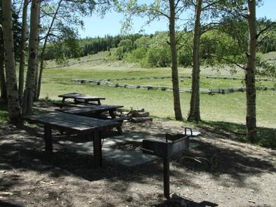
Outside the cabin, guests will find a level parking area for RVs or trailers. A vault toilet, picnic table and campfire ring are provided.

Natural Features

The remote cabin sits on Mount Dutton at the edge of a beautiful meadow with scenic views. A forest of aspens and spruce trees surrounds the broad meadow. Average summer temperatures range from 74 degrees in the daytime, to 42 degrees at night. September temperatures range from 68 to 37 degrees and October temperatures range from 57 to 27 degrees.

Reservation

More from CampingHiking.net:

LAKE DORR CABIN, Florida Campground Images, Info & Reservations

Directions Lake Dorr Cabin is at the southern end of Lake Dorr. Follow SR 19 north from Altoona. Turn left on East Altoona Road onto McCall (CR 8378) to reach the cabin. Total trip takes less than 10 minutes. Phone 352-669-3522 Activities BIKING, BOATING, CAMPING, FISHING, HIKING, HORSEBACK RIDING, SWIMMING

PARKSVILLE LAKE RV CAMPGROUND, Tennessee Campground Images, Info & Reservations

Directions From Highway 64/411 intersection, travel Hwy. 64 east approximately 9.5 miles, turn onto Highway 30 for 0.25 mile. RV sites are located on the left, group tent camping on the right. Phone 423-338-3300 Activities BOATING, CAMPING, FISHING, HIKING, SWIMMING, MOUNTAIN BIKING, KAYAKING, CANOEING, NON-MOTORIZED BOATING, WATER ACCESS, RAFTING, RIVER

BIG SCRUB CAMPGROUND, Florida Campground Images, Info & Reservations

Directions From I-75 east, travel on State Route 40 to Forest Road 588. Turn south on 588 and go approximately 8 miles. The campground is on the west side of the road. Phone 352-625-2520 Activities CAMPING, PICNICKING, WILDLIFE VIEWING Keywords BSCG,SCRUB,NFs IN FLORIDA – FS Related Link(s) Rec Area Info

HIGHLAND RIDGE, Wisconsin Campground Images, Info & Reservations

Directions Interstate 94 east from Minneapolis/St. Paul to Exit 24. Take County Road B at Exit 24 south approximately 2 miles. Follow highway signs east on County Road N for another 2 miles until it intersects County Road NN. Go south on NN for 2 miles until campground entrance sign,

RED BRIDGE (PA), Pennsylvania Campground Images, Info & Reservations

Directions From Warren, Pennsylvania, take PA-59 southeast. Turn right onto Longhouse Scenic Drive (Forest Road 262), then turn left onto State Highway 321 and continue to the campground on your left. Fromthe east, take PA-59 to PA-321 South and turn left. Continue down PA-321 S to the campground on your

EAST LAKE CAMPGROUND, Oregon Campground Images, Info & Reservations

Directions From Bend, travel 23.5 miles south on Hwy 97, then 16.6 miles east on Road 21. Phone 541-383-5300 Activities CAMPING Keywords Related Link(s) Rec Area Info & Images Oregon State Road Conditions Oregon State Tourism Overview East Lake Campground sits at the edge of beautiful East Lake in the