CHEOAH POINT CAMPGROUND, NC Campground Reservation, Info, Images, Map, Directions

CHEOAH POINT CAMPGROUND, North Carolina Campground Images, Info & Reservations

Directions

From Robbinsville, North Carolina, continue on Highway 129 north for approximately 6 miles. Turn left on SR # 1145 – Thunderbird Mountain Road. Continue approximately 1.3 miles on Thunderbird Mountain Road to the Cheoah Point Campground.

Phone

828-479-6431

Activities

BOATING, CAMPING, FISHING, HIKING, SWIMMING, WATER ACTIVITIES, KAYAKING, CANOEING, NON-MOTORIZED BOATING, WATER ACCESS, JET SKIING

Keywords

CPCA,NFs IN NORTH CAROLINA – FS

Related Link(s)

Rec Area Info & Images

North Carolina State Road Conditions

North Carolina State Tourism

Overview

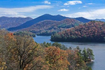
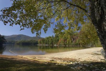
Cheoah Point Campground lies on a peninsula of the vast Lake Santeetlah in the hills of western North Carolina. The lake and surrounding landscape provide countless recreational opportunities for outdoor enthusiasts.

Recreation

Anglers enjoy fishing for trout, walleye, a variety of bass, bream and crappie and more in the 2,800-acre Lake Santeetlah. Boating, canoeing, jet skiing and swimming are also popular activities on the lake. Nearby, the Wauchecha Bald Trail, which begins as a an easy hike and gets progressively more difficult, provides access to the famed Appalachian Trail.

Facilities

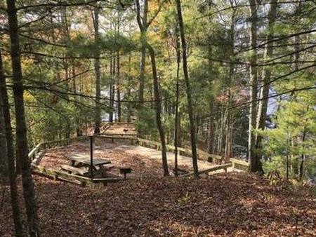
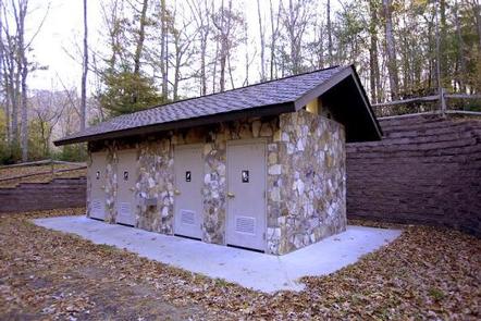
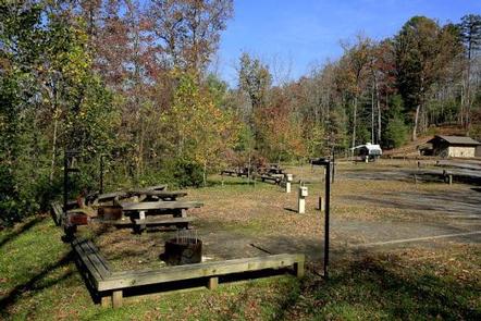
The campground provides multiple open and wooded campsites that can accommodate up to 10 guests and 2 vehicles per site. Six RV sites provide 15/30/50 amp electrical hookups. Tables and campfire rings with grills are provided at each site. Flush toilets, hot showers and drinking water are provided to help create a comfortable camping experience.

Natural Features

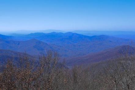
Lake Santeetlah sits in the Nantahala National Forest, which covers 1.3 million acres of mountain lands. Old forests grace the hills and valleys, with some of the canyons reaching deep into the earth, providing ample hiking opportunities in the beautiful terrain. Cheoah Point is situated in a forest of mature hardwoods at an elevation of 1,760 feet. The campground covers steep terrain and many of the campsites overlook the lake.

Nearby Attractions

Great Smoky Mountains National Park is just a short distance away, offering an ideal day trip from Cheoah point Recreation Area.

Reservation

More from CampingHiking.net:

CHILATCHEE CREEK, Alabama Campground Images, Info & Reservations

Directions From Alberta, Alabama, take State Route 5. Turn onto Wilcox County Road 29 and travel southeast for 11 miles. Make a left on Chilatchee Creek Road and continue for 2 miles to the campground. Phone 334-573-2562 Activities BOATING, CAMPING, FISHING, HUNTING, VISITOR CENTER, WILDLIFE VIEWING Keywords CHIL,GEES BEND,ALABAMA RIVERS,MILLERS

PANHANDLE, Washington Campground Images, Info & Reservations

Directions From downtown Newport, travel east on U.S. Highway 2 for 0.75 miles. Immediately after crossing the Pend Oreille River bridge, turn left on LeClerc Road and travel 32 miles north to Panhandle Campground. Phone 509-447-7300 Activities BOATING, CAMPING, FISHING, SWIMMING SITE Keywords PANH,COLVILLE NF – FS Related Link(s) Rec

WHITE SULPHUR SPRINGS CABIN, Alaska Campground Images, Info & Reservations

Directions Accessible year round, weather permitting. Located 65 miles northwest of Sitka on Chichagof Island within the West Chichagof-Yakobi Wilderness Area. Boat access is possible with anchorage in Mirror Harbor, where 0.9-mile White Sulphur Springs Trail leads to the cabin; however, local knowledge is recommended before attempting anchorage there. White

LOST CREEK GROUP, California Campground Images, Info & Reservations

Directions From Redding, California drive 48 miles east on State Highway 44 to State Highway 89. Turn right into Lassen Volcanic National Park and continue five miles south to Lost Creek Group Campground. It is 1/8-mile south of Crags Campground. Phone 530 595-6121 Activities BOATING, HISTORIC & CULTURAL SITE, CAMPING,

MOUNT RYNDA CABIN, Alaska Campground Images, Info & Reservations

Directions Accessible by shallow draft boat and float plane during moderate to high river levels, 18 miles from Wrangell. Low river levels limit small boat access as the Andrews Creek entrance becomes blocked. Tides may affect access; consult local tide tables. A tide of 14 feet or higher is needed

PIONEER PARK, Washington Campground Images, Info & Reservations

Directions From downtown Newport, travel east on U.S. Highway 2 for 0.75 miles. Immediately after crossing the Pend Oreille River bridge, turn left on LeClerc Road and travel 2 miles north to the campground. Phone 509-447-7300 Activities BOATING, CAMPING, FISHING, HIKING Keywords PIOR,COLVILLE NF – FS,PIONEER Related Link(s) Rec Area