THREE LAKES, MI Campground Reservation, Info, Images, Map, Directions

THREE LAKES, Michigan Campground Images, Info & Reservations

Directions

From Strongs Corner, turn south on Forest Road 3142 and travel approximately two miles. The campground is on the east side of the road.

Phone

(906) 643-7900

Activities

BOATING, CAMPING, FISHING, HIKING, SWIMMING SITE

Keywords

THRE,Three Lake Campground,Softball Campground,HIAWATHA NF – FS

Related Link(s)

Rec Area Info & Images

Michigan State Tourism

Michigan State Road Conditions

Overview

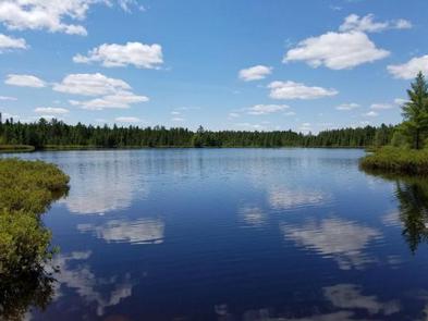
Three Lakes Campground is a peaceful facility tucked away from the busy highway. It is nestled between Whitmarsh, Brown and Walker Lakes, giving visitors ample opportunity to enjoy and explore nature at its best.

Recreation

The three lakes are open to non-motorized boating. A carry-down boat ramp is located at the campground’s picnic area. Fishing is a popular activity. Rainbow trout, perch and catfish are found in the lakes. Although there is no designated swimming beach, sandy areas are located along the shores of the three lakes.

Hikers enjoy the serene atmosphere of the campground. The Walker Loop Trail begins within the campground, near the picnic area, and leads hikers around the perimeter of Walker Lake. The trail is easy hiking and traverses about 1.15 miles.

Facilities

Three Lakes Campground is a rustic campground with single-family sites for tent and RV camping. Each is equipped with a table and campfire ring. Vault toilets and drinking water are provided. A day-use picnic area is also available.

Natural Features

The campground is set among a variety of pine, spruce and maple trees on land sandwiched between Lake Superior and Lake Michigan. Whitmarsh, Brown and Walker Lakes dot the landscape to the north, south, and west of the campground.

Nearby Attractions

The nearest town is Strongs, just 2.5 miles from the campground.

Reservation

More from CampingHiking.net:

STATION CREEK CAMPGROUND, Wyoming Campground Images, Info & Reservations

Directions From Jackson, travel south on Highway 191/89/26 for about 13 miles, to Hoback Junction. Turn right onto Highway 26/89 and continue along the Snake River Canyon for 14 miles. The campground is on the north side of the road. Phone 541-351-1182 Activities BOATING, CAMPING, FISHING, HIKING, WATER SPORTS Keywords

TIONESTA REC. AREA CAMPGROUND, Pennsylvania Campground Images, Info & Reservations

Directions From Tionesta, PA: Go 0.5 mile south on SR 36 and follow signs into the campground. Phone 814-755-3512 Activities BOATING, CAMPING, FISHING, HIKING, PICNICKING, WILDLIFE VIEWING, WILDERNESS, ENVIRONMENTAL EDUCATION, PHOTOGRAPHY, RANGER STATION, CANOEING, DISC GOLF, RECREATION PROGRAMS, SCENIC DRIVE Keywords TIONESTA DAM,TIONESTA LAKE,OUTFLOW CAMP LEFT BANK,TIONESTA OUTFLOW CAMPGROUND,TIONESTA CAMPGROUND,TIONESTA

MANISTIQUE – RAPID RIVER DISPERSED CAMPSITES, Michigan Campground Images, Info & Reservations

Directions All driving directions are listed by lake. Please check campsite details. Phone 906-474-6442 Activities BIKING, BOATING, CAMPING, FISHING, HIKING, HORSEBACK RIDING, WATER SPORTS, WILDLIFE VIEWING, DAY USE AREA, SWIMMING SITE Keywords Dispersed campsites,Manistique,Rapid River,lyman lake,swan lake,bass lake,bear lake,camp cook,carr lake,chicago lake,clear lake,crooked lake,east lake,gooseneck lake,ironjaw lake,jackpine lake,lake nineteen,leg lake,little

YELLOWJACKET, California Campground Images, Info & Reservations

Directions From Placerville, take Highway 50 east. Go 21 miles to Icehouse Road. Turn left on Icehouse Road. Then drive 14 miles north to the Yellowjacket turnoff. Drive a half mile to the campground entrance. Phone 530-293-0827 Activities BIKING, CAMPING, FISHING, HIKING, HUNTING, WATER SPORTS, WILDLIFE VIEWING, SWIMMING SITE, BIRDING,