


Directions
From Detroit Ranger Station, drive east on State Highway 22 toward the town of Detroit. Directly after crossing the bridge, take a left onto Forest Service Road (FSR) 46 (Breitenbush). Drive FSR 46 for about 4 miles to FSR 4696. Turn left (northeast) onto FSR 4696 and drive about three-quarters of a mile to FSR 4697. Turn left (north) onto FSR 4697 and drive about 5 miles to the saddle. Turn right onto FSR 451 and proceed to the first right (FSR 453). Proceed through the gate approximately half a mile to the parking area at the second green gate.
The last 2 miles of road access are rough gravel and dirt at a 10 percent uphill grade. Low clearance vehicles are not recommended.
The lookout is located approximately half a mile from the parking area. You will be hiking on a road to a saddle and from there a steep trail to the summit.
Phone
503-854-3366
Activities
CAMPING, HIKING, WILDLIFE VIEWING, PHOTOGRAPHY, BERRY PICKING, STAR GAZING, BIRDING, HISTORIC SITES
Keywords
GLDB,WILLAMETTE NF -FS
Related Link(s)
Overview
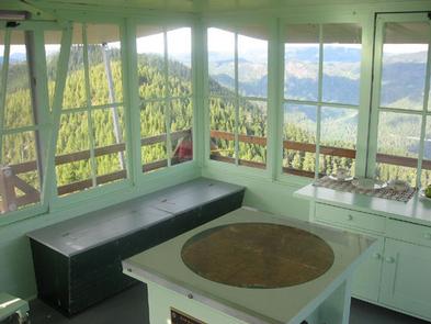
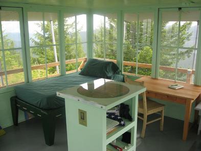
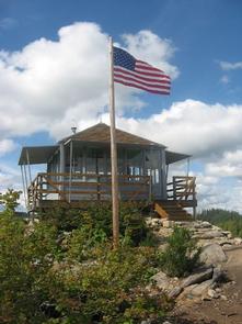
The Gold Butte Lookout sits on the summit of Gold Butte at an elevation of 4,618 feet in the Willamette National Forest. It was built in 1934 by the Civilian Conservation Corps. During World War II, the lookout served as part of Aircraft Warning System station in defense of the nation against air attack. It was staffed around the clock, usually by a husband and wife team, who reported all passing aircraft within sight or sound to a central filter center. The lookout stands on 3-foot stilts and is surrounded by glass windows and an exterior catwalk, offering a panoramic view of the Cascades. It is furnished with refurbished or replica furniture. The lookout is typically open from early July through mid-October. It is accessible by car, but guests should be prepared to walk the last half mile on difficult and steep terrain to reach the lookout. A high clearance vehicle is recommended for the drive. Guests will need to pack in most of their own supplies and gear.
Recreation
In addition to relaxing and taking in the incredible views from Gold Butte, guests can venture out and experience other recreation opportunities nearby. Canoeing and fishing is possible in peaceful Elk Lake. Day hiking is a popular pastime in the adjacent Bull of the Woods and Opal Creek Wilderness Areas or nearby Mt. Jefferson Wilderness.
Facilities
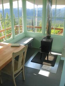
The 14×14-ft. wood cabin accommodates 4 people and comes equipped with 1 twin bed with mattress and 3 folding cots. Other amenities include a table, bench, chair, cabinet, wood bins, fire extinguisher, broom, dustpan, cleaning supplies, dishes and utensils. A wood stove is provided for heat. An outhouse and a woodshed stocked with firewood are located nearby. An axe may be available for chopping wood. Water, a cook stove and electricity are not provided. Guests must bring enough water for drinking, cooking and washing. Items such as bedding, lanterns or flashlights, cookware, fire starters, extra toilet paper, first aid supplies, trash bags, dish soap, towels and an ice chest are not available. This facility is opened and closed by the Sand Mountain Society. Guests are expected to pack out their trash and clean the cabin before leaving.
Natural Features
Guests at the lookout can enjoy panoramic views of the Cascade Range, including nearby Mt. Jefferson, Three Fingered Jack, Mt. Hood, the Three Sisters and Bull of the Woods Wilderness Area. Seasonal wildflowers and wild huckleberries grow nearby. Willamette National Forest offers prime habitat for such species as Roosevelt elk, black bear, bald eagles, blacktail deer and bobcats, among other wildlife.