

Directions
From Butte Falls, OR, drive east on the Butte Falls – Fish Lake Highway (County Road 821). Less than a mile from town, turn left onto the Butte Fall – Prospect Highway (County Road 992) and travel north on County Road 992. Go 9 miles on County Road 992 to Forest Road 34. Turn right, go 5 miles on Forest Road 34 until its junction with Forest Road 3400-600. Unlock the gate and travel north / northeast on Forest Road 3400-600 for 1 mile. Turn left through gate and proceed 200 yards to the guard station. For an alternative route to Lodgepole that bypasses the town of Butte Falls, take State Highway 62 to the town of Prospect, OR. At the Prospect Hotel turn east onto the Butte Falls – Prospect Highway (County Road 992), travel approximately 14 miles and take the left turn on Forest Road 34. Travel 5 miles on Forest Road 34 until its junction with Forest Road 3400-600. Unlock the gate and travel north / northeast on Forest Road 3400-600 for 1 mile. Turn left through the gate and proceed 200 yards to the guard station.
Phone
541-865-2700
Activities
CAMPING, HIKING, HORSEBACK RIDING, MOUNTAIN BIKING
Keywords
None
Related Link(s)
Overview
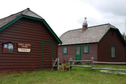
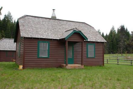
The guard station at Lodgepole Meadow was built in 1935 by the Civilian Conservation Corps to replace the original station built in 1911. Lodgepole Meadow was used as a remote guard station for the early Forest Service crews working in the area.
During WWII, Herb and Zella Wright, a husband and wife lookout team, lived throughout the winter high up on the Blue Rock Lookout several miles away watching for enemy aircraft. Lodgepole Guard Station served as their base camp.
Today, Lodgepole Guard Station is a perfect destination for horse enthusiasts, families, couples or large groups looking for a unique camping experience in the Rogue River-Siskiyou National Forest.
Recreation
The meadow offers plenty of room and even terrain for a large group of visitors to spread out, camp, horseback ride, hike, mountain bike or just relax.
Additional horseback riding trails are a short trailer ride away, and include the Alta Lake, Middle Fork and Seven Lakes Trails, all of which lead into the Sky Lakes Wilderness.
Facilities
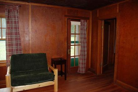
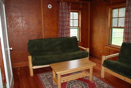
Considered to be an outstanding example of Civilian Conservation Corps construction in the Pacific Northwest, the one story cabin offers a large living room, kitchen and bathroom. The cabin is furnished with a full-sized bed with a mattress and a log style couch (with a fold-out bed). The kitchen is equipped with a refrigerator and stove, powered by propane fuel, basic cooking utensils, a table and chairs. The bathroom has a flush toilet and shower.
A propane heater provides heat for the cabin. Lighting is not available at the site, so bringing an additional light source is necessary.
Guests will need to bring several of their own supplies, including food, sleeping bags, sleeping pads, towels, dish soap, matches, toilet paper and garbage bags.
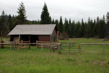
A former bunkhouse, tool shed, barn and stable with several horse paddocks, are also on site. There is additional space for tent camping, as the existing yard can accommodate up to three, 4-person, family size (9′ x 12′) tents.
Natural Features
Lodgepole Guard Station is surrounded by 40 acres of cross-fenced pastures dotted with pines, and surrounded by forested rolling hills. The large grassy meadow has a long history of being a major grazing area for horses and cattle, and that tradition continues today.
Diverse landscapes of the Rogue River Siskiyou National Forest provide habitat for a wide-range of wildlife in the area, including spotted owls and bull elk to salamanders and salmon. These species, along with many others, depend on the surrounding undeveloped wilderness, undisturbed wetlands, clean streams, and diverse forests to live.
Nearby Attractions
Visit Crater Lake National Park and learn about its unique natural and cultural history. At a depth of 1,943 feet, Crater Lake is the deepest lake in the United States and one of the 10 deepest lakes in the world.
Experience 172 miles of diverse river and mountain landscapes along the Rogue-Umpqua National Scenic Byway. Travel from rolling oak-covered hills and towering coniferous forests, to roaring white water rapids and incised inter-canyon lava flows. The highway travels alongside the Upper Rogue and North Umpqua Wild and Scenic Rivers that contain world-class fisheries.