TEJAS PARK, TX Campground Reservation, Info, Images, Map, Directions

TEJAS PARK, Texas Campground Images, Info & Reservations

Directions

From I-35, take Williams Drive west, then turn south on Farm to Market Rd 3405. Turn east on County Rd 258 and continue across the North San Gabriel River. Turn left into Tejas Park.

Phone

512-930-5253

Activities

CAMPING, FISHING, HIKING, HUNTING, WILDLIFE VIEWING, PADDLING, MOUNTAIN BIKING, WATER ACTIVITIES

Keywords

None

Related Link(s)

Rec Area Info & Images

Texas State Tourism

Texas State Road Conditions

Overview

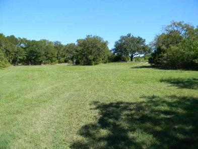
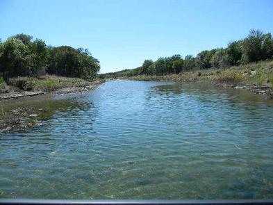
Tejas Park sits on the south side of Georgetown Lake in the Hill Country of Texas, about 25 miles north of Austin. Tejas park sits upon the south bank of the North San Gabriel River offering good opportunities for fishing, wading or floating and features plenty of large, grassy open areas for running around and enjoying the scenic Texas countryside.

Recreation

Boating is the most popular way to enjoy the clear waters of the lake. Fishing is excellent in the area, and the lake contains Black bass, White bass, Hybrid stripers, White crappie, Channel catfish and Flathead catfish, but its most known for its abundance of Smallmouth bass. The San Gabriel River Trail is a 26 mile rugged trail winding through dense juniper forest, hardwood bottomlands and prairie grasslands. The trail wraps completely around Georgetown Lake via the dam and is open to both hiking and biking. Hunting is available for for small game like dove, waterfowl, rabbit and squirrel, as well as white tail deer.  Hunting is by permit only.

Facilities

Tejas Park has 12 primitive campsites, allowing visitors to enjoy the outdoor experience with the added convenience of a picnic table with grills and fire rings. A Group Area is available for use by larger groups (maximum 25 people). The group site does not have a shelter.

Natural Features

Lake Georgetown is a reservoir on the north fork of the San Gabriel River in central Texas. The dam was completed in 1979 to provide flood control and water supply for the nearby community of Georgetown, and now provides countless recreation opportunities for outdoor enthusiasts.

Nearby Attractions

The nearby town of Georgetown offers gas, groceries and more. The historic downtown square district has shops and restaurants, and concerts and events are held on a regular basis.

Additionally, Austin is located just 25 miles from the lake, offering countless tourist attractions.

Reservation

More from CampingHiking.net:

RUSSIAN RIVER, Alaska Campground Images, Info & Reservations

Directions From Anchorage, Alaska, travel south for 110 miles to Milepost 54 on the Sterling Highway, Alaska State Highway 1. Phone (907)288-7756 Activities BIKING, CAMPING, FISHING, HIKING Keywords RUSR,CHUGACH NF – FS Related Link(s) Rec Area Info & Images Alaska State Tourism Alaska State Road Conditions Forest Service Concessionaire Overview

SPRING CREEK CAMPGROUND, Idaho Campground Images, Info & Reservations

Directions From Weiser, Idaho, travel north on Highway 95 for approximately 12 miles, then turn onto Upper Mann Creek Road/Forest Road 009 and travel another 18 miles to the campground. Phone 208-549-4200 Activities BIKING, CAMPING, FISHING, HIKING, HUNTING, WILDLIFE VIEWING, DAY USE AREA Keywords SPCK,SPRING CREEK GROUP SITE,SLEEPING SPRINGS INTERPRETATION,PAYETTE

JENNINGS FERRY, Alabama Campground Images, Info & Reservations

Directions From Demopolis, Alabama, take Highway 43 north towards Eutaw. At Highway 14, take a right. Proceed for approximately seven miles to the park. Phone 205-372-1217 Activities CAMPING, FISHING, HIKING Keywords JENF,BLACK WARRIOR Related Link(s) Rec Area Info & Images Alabama State Tourism Alabama State Road Conditions Overview Jennings Ferry

DRY GULCH, California Campground Images, Info & Reservations

Directions From Highway 140, turn on to Foresta Road. Landmarks include Red Bud Picnic Area and a National Park Service warehouse. After bridge, turn left onto the spur road. Immediately turn left onto Incline Road. Continue 1.3 miles to the facility. Phone 559-642-3212 Activities CAMPING Keywords DRYG,EL PORTAL,MERCED RIVER,SIERRA NF

RED BRIDGE (PA), Pennsylvania Campground Images, Info & Reservations

Directions From Warren, Pennsylvania, take PA-59 southeast. Turn right onto Longhouse Scenic Drive (Forest Road 262), then turn left onto State Highway 321 and continue to the campground on your left. Fromthe east, take PA-59 to PA-321 South and turn left. Continue down PA-321 S to the campground on your