Directions
Take I-85 north to I-985, take Exit 8, turn left on Highway 347/Friendship Road. Turn right on McEver Road, then left on Gaines Ferry Road and follow signs to the campground.
Phone
770-967-6315
Activities
BOATING, CAMPING, FISHING, PICNICKING, WATER ACTIVITIES, WATER ACCESS
Keywords
VAN PUGH SOUTH CAMPGROUND (GA),Van Pugh South Campground,LAKE LANIER,LAKE SIDNEY LANIER
Related Link(s)
Overview
Van Pugh South Campground lies on the banks of Lake Sidney Lanier in the foothills of the Blue Ridge Mountains of Northern Georgia. The popular lake boasts nearly 700 miles of shoreline and over 100 small islands, providing over 11 million annual visitors with limitless recreation opportunities.
Recreation
Lake Lanier offers excellent boating, fishing and swimming. The lake offers additional opportunities for kayaking, wake boarding and much more.
Facilities
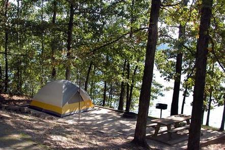
The campground contains 37 sites with water and electric hookups and 18 primitive tent-only sites. Amenities include accessible flush toilets and showers, drinking water, laundry facilities and a dump station. An accessible boat ramp is on-site.
Natural Features
The reservoir was created in 1956 with the completion of Buford Dam on the Chattahoochee River, and today spans 38,000 acres of water in the lush foothills of the Blue Ridge Mountains. Dense forests of oak, hickory and pine cover the region, providing shade in the campground and abundant wildlife habitat.
Nearby Attractions
Lake Lanier Islands is within driving distance and along with other parks provides many opportunities for outdoor recreation. There are several towns within driving distance that provide opportinuties to explore.
Charges & Cancellations
Cancellations must be made via the online/phone reservation system or in person at the gatehouse. Cancellation calls to the gatehouse will not be honored.

