
Directions
From Phoenix, travel north on Interstate 17 to exit 306 (Stoneman Lake Road/Forest Road 213). Go east on Stoneman Lake Road for approximately 6.5 miles, to the junction with Forest Road 229. Turn right onto Forest Road 229 and go 4.5 miles to Forest Road 230. Veer right, continuing on Forest Road 229 and continue approximately a quarter-mile to the intersection of Forest Road 229 and Forest Road 620 (to the Apache Maid Lookout). Veer right; the gate to the cabin is at this intersection, on the left side of the road. Look for the small sign for Apache Maid Cabin. Note: the cabin is not on the mountain; if you are driving uphill toward the mountain, you have missed the cabin entrance gate.
Access to the cabin is through a locked gate. The gate has a combination lock, and a house key is located in a lock box on the kitchen door. Combination codes for the gate and the lock box are given in the reservation confirmation letter. High-clearance vehicles are recommended, and four-wheel drive is required during inclement weather.
Phone
928-282-4119
Activities
BIKING, HISTORIC & CULTURAL SITE, CAMPING, FISHING, HIKING, HUNTING, WILDLIFE VIEWING, FIRE LOOKOUTS/CABINS OVERNIGHT
Keywords
APACHE MAID CABIN (AZ),Apache Maid Cabin,Apache Maid,AM Cabin,AMC
Related Link(s)
Overview
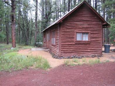
This rustic forest cabin is located at the eastern base of Apache Maid Mountain, just two hours north of Phoenix and near the popular red rock canyons and outdoor recreation opportunities of Sedona, in central Arizona. The cabin provides several amenities, providing a comfortable stay for up to six people.
It can be accessed by vehicle. Guests are responsible for their own travel arrangements and safety, and must bring several of their own amenities.
Recreation
The area is a hub for outdoor recreation. Although there are no trails immediately around the cabin, countless hiking, mountain biking and horseback riding trails are located within an hour drive. Closer to the cabin, anglers can fish for northern pike, yellow perch and sunfish at nearby Stoneman Lake, one of the few natural lakes in Arizona. Bird watchers can delight in watching for migratory waterfowl and summer songbirds from the shoreline, and families can enjoy an afternoon of picnicking.
Facilities
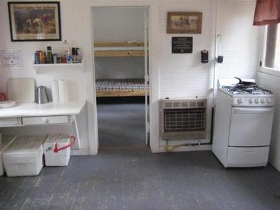
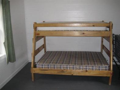
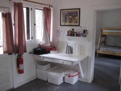
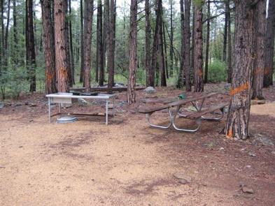
The facility is a small, 520 square-foot cabin that can accommodate up to six overnight visitors. It has one bedroom with bunk beds and a roll-away bed, a living room with a futon couch, and a kitchen and dining room. All the beds have mattresses. The kitchen has a propane stove with dishes, pots and pans, but no refrigerator. The building is also equipped with a propane heater and has limited solar-supplied overhead lighting system with wall switches in each room. The cabin does not have any available outlets.
Visitors must bring their own food and potable water for drinking, cooking and cleaning, bedding (sheets, blankets, pillows and/or sleeping bags), towels for the kitchen, weather appropriate clothing, dish soap, flashlights and an axe for splitting wood at the outdoor fire pit.
Users must clean the cabin and pack out all food and trash before leaving.
Natural Features
The facility was originally constructed in 1909 by Charles Babbitt and served as a ranch house for cattlemen, then later as a U.S. Forest Service ranger station. It has been restored to its historic character.
The cabin is surrounded by the shade of a ponderosa pine forest and is just south of the Mogollon Rim, a 200-mile slope that ranges between 5,000 and 7,000 feet in elevation. The cabin sits at 6,382 feet and has summers that are characteristically sunny, warm and dry, with the occasional afternoon thunderstorm.
Nearby Attractions
Nearby Stoneman Lake, Beaver Creek and Sedona offer numerous recreation activities and cultural attractions.