LAWRENCE RECREATION AREA, PA Campground Reservation, Info, Images, Map, Directions

LAWRENCE RECREATION AREA, Pennsylvania Campground Images, Info & Reservations

Directions

From US 15 South, take the Lawrenceville Exit. At the bottom of the ramp, turn right onto State Route 49. Recreation Area will be on the right approxmately 4 miles.

From US 15 North, take the Lawrenceville exit. At the bottom of the ramp turn left. Recreation area will be on the right approximately 5 miles.

Phone

570-835-5281

Activities

CAMPING, FISHING, HIKING

Keywords

LAWRENCE RECREATION AREA (PA),Cayuga Shelter

Related Link(s)

Rec Area Info & Images

Pennsylvania State Tourism

Pennsylvania State Road Conditions

Overview

Lawrence Recreation Area is a day-use facility on the south side of Cowanesque Lake. It is conveniently located on State Route 49 approximately 4 miles west of Lawrenceville, Pennsylvania. The area offers a great location for picnicking and shoreline fishing.

Recreation

Cowanesque Lake offers many outdoor activities including boating and fishing. A variety of native fish inhabits the area’s streams and lakes. The North and South Tailrace areas provide access for fishing below the dam.

The fields and forests around the lake are popular destinations for hunters looking for large and small game species that inhabit the eastern hardwood forests.

Many miles of hiking trails surround the lake, including the Mid State Trail, which links the trails at Cowanesque and nearby Hammond Lake into a long path that extends all the way through Pennsylvania from Maryland to New York.

Facilities

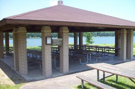
The Cayuga Shelter is reservable for group picnicking. It is fully accessible and comfortably accommodates groups of up to 100 people in a lovely lakeside setting.

Natural Features

Cowanesque Lake is situated in the Endless Mountains region of Pennsylvania, along the Allegheny Plateau in the Appalachian Mountains. The surrounding land paints a scenic picture of rolling terrain and open fields.

Reservation

More from CampingHiking.net:

MCKASKEY CREEK CG, Georgia Campground Images, Info & Reservations

Directions Take I-75 N to Exit 290 (Canton/Rome/GA Hwy 20), Continue east onto GA 20; take an immediate right onto GA SPUR 20 for 2 miles, then turn left onto McKaskey Creek Road and travel 1 mile to campground. Physical Address: 358 McKaskey Creek Rd, Cartersville, GA 30121 Phone 678-721-6700

DEER CREEK LAKE DAY USE, Ohio Campground Images, Info & Reservations

Directions From Columbus, Ohio, take Highway 62 south to Mt. Sterling. Turn south on Route 207 and continue for 8 miles to the lake. Turn at the intersection; picnic shelter is on Crownover Mill Road. Phone 740-869-2243 Activities BOATING, CAMPING, FISHING, HIKING, HUNTING, SWIMMING SITE Keywords DCBD,BELOW DAM AREA,PICNIC SHELTER

DIMOND O, California Campground Images, Info & Reservations

Directions From the Groveland District Office, head east 15 miles on Highway 120, then turn left on Evergreen Road and travel 4 miles. The campground is located on the left. Phone 209-379-2258 Activities BIKING, BOATING, CLIMBING, CAMPING, FISHING, HIKING, CANOEING, ROCK CLIMBING Keywords DIMO,DIAMOND O,DIMOND O,STANISLAUS NF -FS,Diamond (CA) Related

PINEY GUARD STATION, Colorado Campground Images, Info & Reservations

Directions Take I-70 east from Grand Junction, CO, about 126 miles or heading west from Denver about 119 miles to exit 157. Take Highway 131 north through the town of Wolcott about 5 miles. Turn right onto Forest Road #700 (Muddy Pass Road). From this location, you must follow seasonal

APGAR GROUP SITES, Montana Campground Images, Info & Reservations

Directions Located 1 mile northeast of the west entrance near West Glacier, Montana. Access is from U.S. Highway 2, approximately 32 miles northeast of Kalispell, Montana. Phone 406-888-7800 Activities BIKING, BOATING, CAMPING, INTERPRETIVE PROGRAMS, FISHING, HIKING, VISITOR CENTER, WILDLIFE VIEWING, DAY USE AREA, SWIMMING SITE Keywords Apgar Campground,Apgar,Glacier,Glacier National Park,APGAR

COLUMBINE CAMPGROUND (NM), New Mexico Campground Images, Info & Reservations

Directions Five miles east of Questa, New Mexico via NM highway 38. Phone 435-245-6521 Activities CAMPING, FISHING, HIKING, VISITOR CENTER, WILDLIFE VIEWING Keywords Related Link(s) Rec Area Info & Images New Mexico State Road Conditions New Mexico State Tourism Overview Columbine Campground is located between Questa and Red River, New