ROCKY CREEK PARK (BENBROOK LAKE), TX Campground Reservation, Info, Images, Map, Directions

ROCKY CREEK PARK (BENBROOK LAKE), Texas Campground Images, Info & Reservations

Directions

From the intersection of Granbury Road / Summer Creek Drive and Sycamore School Road / Columbus Trail, go west and southwest 1.5 miles (2.6 km) to the intersection of Granbury Road, McPherson Road and St. Francis VIllage Road. Proceed on Rocky Creek Park Road 1 mile (1.6 km) to the park entrance. Or from the Chisholm Trail Parkway, exit for McPherson Road and go west to Rocky Creek Park Road.

Phone

817-292-2400

Activities

BOATING, CAMPING, FISHING, HIKING, PICNICKING, WILDLIFE VIEWING, DAY USE AREA

Keywords

ROCKY CREEK PARK (BENBROOK LAKE) (TX),Benbrook,Benbrook Lake

Related Link(s)

Rec Area Info & Images

Texas State Tourism

Texas State Road Conditions

Overview

Rocky Creek Park is on the east side of Benbrook Lake in north central Texas, accessible form Granbury Road or McPherson Road. Picnicking, camping, hiking & horseback trails, boat launch, and fishing are available.

Recreation

Picnicking, fishing, boating, hiking and birding are all available in the Rocky Creek Park Primitive, seasonal camping may be available.

Facilities

Drinking water, vault tolets, and boat launching ramps are available in both the picnic areas and campground.. There are several miles of hiking & horseback trail accessible from Rocky Creek Park. The primitive campground offers tent & RV sites but without utility hookups.

Natural Features

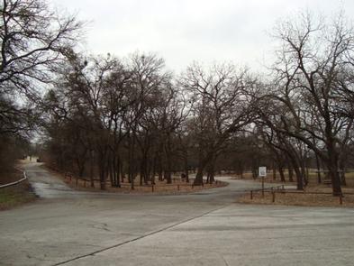
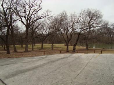
The park is on the east side of wooded Rocky Creek. The main picnic area lies on an open peninsula below wooded hillsides. The wooded campground is up the creek.

Nearby Attractions

Fort Worth’s renowned Cultural & Museum District, Stockyards National Historic District, Botanical Gardens, Zoo, Bass Performance Hall, and downtown Sundance Square are all only as hort drive.

Reservation

More from CampingHiking.net:

DIFFICULT CAMPGROUND, Colorado Campground Images, Info & Reservations

Directions Take Highway 82 for 5 miles southeast of Aspen, Colorado. Look for USFS Difficult Campground sign on the right, past Mile Marker 45. Phone 970-927-0107 Activities CAMPING, FISHING, HIKING, WILDLIFE VIEWING Keywords DIFF,ASPEN COLORADO,INDEPENDENCE PASS,DIFFICULT CAMPGROUND GRP SIT,WHITE RIVER NF -FS Related Link(s) Rec Area Info & Images Forest

WOLF CREEK CALIFORNIA, California Campground Images, Info & Reservations

Directions From Placerville, get on Highway 50 and head east for 21 miles to Icehouse Road. Turn left 21 miles to turnoff. Then go three-quarters of a mile to campground. Phone 831-245-6891 Activities BIKING, BOATING, CAMPING, FISHING, HIKING, WATER SPORTS, WILDLIFE VIEWING, SWIMMING SITE, BIRDING, WATER SKIING Keywords WOLA,ELDORADO NF

STONY POINT, Minnesota Campground Images, Info & Reservations

Directions From Walker, Minn., take Highway 200 east 6 miles to County Road 13. Go north 3 miles on County Road 13 to Forest Road 3793, then east 2.5 miles on FR 3793 to the campground. Phone 218-547-1044 Activities BOATING, CAMPING, FISHING, HIKING, SWIMMING SITE Keywords STOP,CHIPPEWA NF – FS

ACKER ROCK LOOKOUT, Oregon Campground Images, Info & Reservations

Directions Important note regarding GPS use: please be advised that GPS units can, and have sent guests down the wrong roads to access the Lookout. Please consider following the directions below rather than your GPS unit. Directions: From Canyonville take West 1st Street and turn onto SE 3rd St/OR-227. Continue

LIMBERLOST CAMPGROUND, Oregon Campground Images, Info & Reservations

Directions From McKenzie Bridge, travel east on Hwy 126 to Hwy 242. Follow Hwy 242 approximately 2 miles east to Limberlost Campground. Phone 801-226-3564 Activities BIKING, BOATING, HIKING Keywords Limberlost Campground Related Link(s) Rec Area Info & Images Forest Service Concessionaire Oregon State Road Conditions Oregon State Tourism Overview This