BEAR SPRINGS GROUP CAMPGROUND, OR Campground Reservation, Info, Images, Map, Directions

BEAR SPRINGS GROUP CAMPGROUND, Oregon Campground Images, Info & Reservations

Directions

From Sandy: Travel east on Highway 26 for 48 miles to the Highway 26/I-216 junctions. Turn left onto I-216 and travel east for 4 and 1/4 miles. Turn Right at Bear Springs campground.

Phone

503-630-5721

Activities

CAMPING, WILDLIFE VIEWING

Keywords

Related Link(s)

Rec Area Info & Images

Oregon State Tourism

Forest Service Concessionaire

Oregon State Road Conditions

Overview

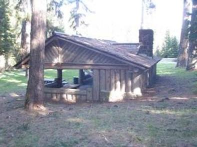
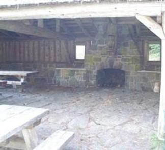
Bear Springs Campground is an ideal destination for families and groups that enjoy the outdoors in the beautiful Pacific Northwest. It offers spacious group sites, single-family sites, and a day use area with a picnic shelter amid a forest of towering trees.

Recreation

Bear Springs is not far from some great wilderness spots, including mountain lakes and streams, as well as trails and historic sites. A variety of short hiking and off-highway vehicle trails are available nearby for exploration. The Mt. Hood area and Government Camp are within a short drive from the campground. For water enthusiasts, rafting and kayaking opportunities abound on the nearby Deschutes River. Picnicking is also a popular activity.

Facilities

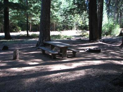
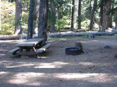
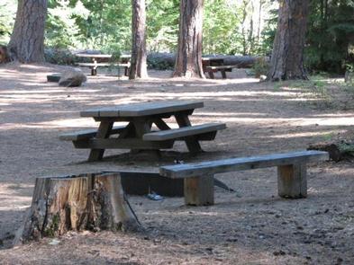
The campground offers single-family and group sites for tent and RV camping. Each site is equipped with a table and campfire ring with grill. Vault toilets, drinking water and trash collection are provided, but utility hookups are not available. Parking surfaces are gravel and dirt. Firewood can be purchased from the host.

Natural Features

The campground is located on the southeastern edge of Mt. Hood National Forest at an elevation of 3,000 feet. It is situated among towering pine and fir trees, but the beauty of the campground is its secluded feel. Deer and other wildlife are common in the area.

Nearby Attractions

Bear Springs is near the Warm Springs Tribal Lands and is approximately 19 miles from Government Camp, where visitors may enjoy summertime snow skiing. It is also approximately 24 miles from the Deschutes River and less than one mile to Spring Drive RV Campground.

Reservation

More from CampingHiking.net:

Midway Campground (FL), Florida Campground Images, Info & Reservations

Directions From Naples: Follow US HWY 41 east until you see signs for campground (approximately mile marker 52) From Miami: Follow US HWY 41 west until you see signs for campground (approximately mile marker 52) Phone 1 (239) 695-1205 Activities CAMPING, DAY USE AREA Keywords Midway Campground,Big Cypress Related Link(s)

QUARRY COVE, Arkansas Campground Images, Info & Reservations

Directions From Ola, Arkansas, take Route 7 south for 9 miles. Turn west onto US-60, and continue for .5 miles and follow signs into campground. Phone 479-272-4233 Activities BOATING, CAMPING, FISHING, SWIMMING SITE Keywords QUAR,NIMROD LAKE,NIMROD LAKE Related Link(s) Rec Area Info & Images Arkansas State Road Conditions Arkansas State

BIG SPRINGS WARMING HUT, Idaho Campground Images, Info & Reservations

Directions From West Yellowstone, Montana, travel 22 miles south on Highway 20 to Mack’s Inn. Turn east on Big Springs Loop Road and travel 2 miles to the warming hut access road. Turn south into the warming hut parking area. Phone 208-558-7658 OR 208-270-0094 Activities CAMPING Keywords BISP,CARIBOU-TARGHEE NF –

DONALDSON PARK, Tennessee Campground Images, Info & Reservations

Directions From Celina, TN (Highway 52), travel East Lake Avenue. Turn onto Jefferson Street. Follow signs into the park. Phone 931-243-3136 Activities BOATING, FISHING, PICNICKING, DAY USE AREA, PHOTOGRAPHY, KAYAKING, CANOEING, WATER ACCESS Keywords DONA,CELINA PARK,DALE HOLLOW LAKE,DALE HOLLOW,DONALDSON,CORDELL HULL DAM Related Link(s) Rec Area Info & Images Tennessee State