
Directions
Cholla Campground is 5 miles north of Roosevelt Dam. From Mesa: Take State Hwy. 87/Beeline Highway north for about 60 miles to its junction with State Hwy. 188. Turn right and follow State Hwy. 188 south for 28 miles to the site. From the Globe area: Take State Hwy. 188 north for 30 miles to its junction with State Hwy. 188. Continue on State Hwy. 188 across the bridge for 6 miles to the site.
Phone
TONTO BASIN RANGER DISTRICT (602) 225-5395
Activities
BIKING, BOATING, CAMPING, FISHING, HIKING, PICNICKING, WILDLIFE VIEWING, PADDLING, KAYAKING, CANOEING, SCENIC DRIVE
Keywords
Related Link(s)
Overview
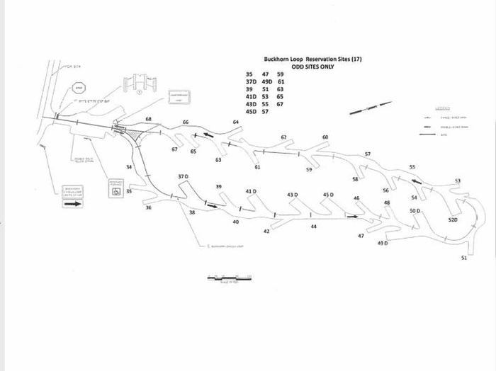
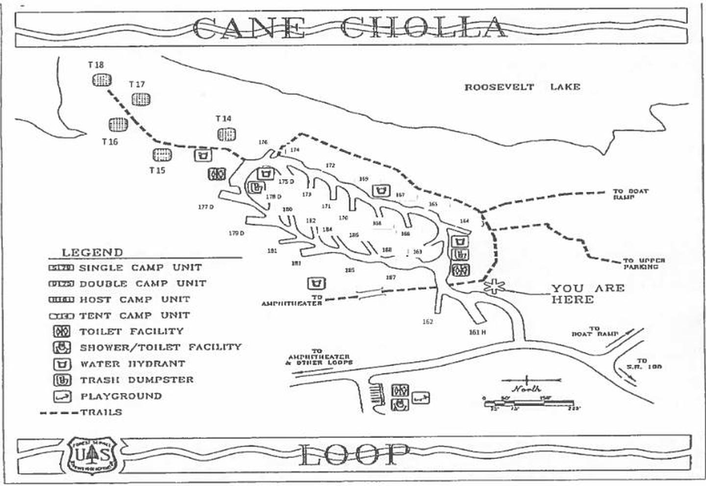
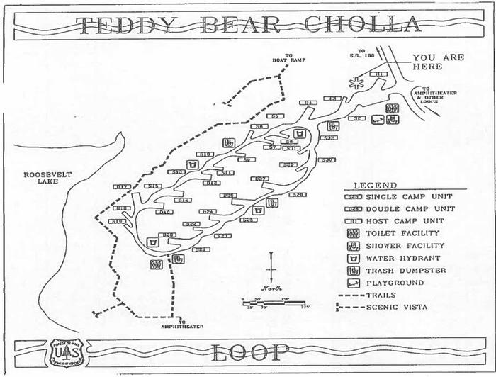
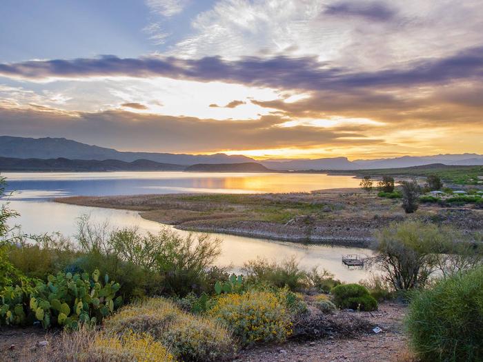
Cholla Campground at Roosevelt Lake, is one of several campgrounds on the shores of the largest lake/reservoir located entirely in the State of Arizona. It is situated within a lush sonoran desert landscape at an elevation of 2168′. Cholla Campground is also the largest solar powered campground in the United States. Each of its 206 campsites have shade ramadas, firepits, grills, and picnic tables. Playgrounds, showers and toilet facilites are scattered throughout the campground. The area around Cholla Campground is often alive with abundant wildlife such as mule deer, coyotes, geese, fox, javalina, and the occasional bald eagle.
Recreation
Recreation opportunities abound at Cholla Campground. Launch your bass boat, ski boat, or pontoon boat from the developed boat ramps within the recreation site and play on the water all day long. If motorsports aren’t your thing, there’s an abundance of places to explore from your kayak, canoe, or paddleboard. While you’re visiting, you can also hike a portion of the Arizona Trail, visit the Tonto National Monument cliff dwellings, explore endless miles of jeep trails or drive a portion of the Apache Trail or Spines to Pines Highway. If if you’re looking for a day in town, consider the easy 45 minute drive Globe or Payson where you can shop for antiques, buy ice cream and learn about Arizona’s rich mining and timber history. Roosevelt Lake is a landscape photograhers dream so don’t forget your camera (and sunscreen).
Facilities
Cholla Campground has 206 campsites. Each site has shade ramadas, firepits, grills, and picnic tables. Scattered throughout the campground are playgrounds, showers and toilet facilites. Highly developed boat ramps with accessible boat boarding ramps are also available within the Campground.
Natural Features
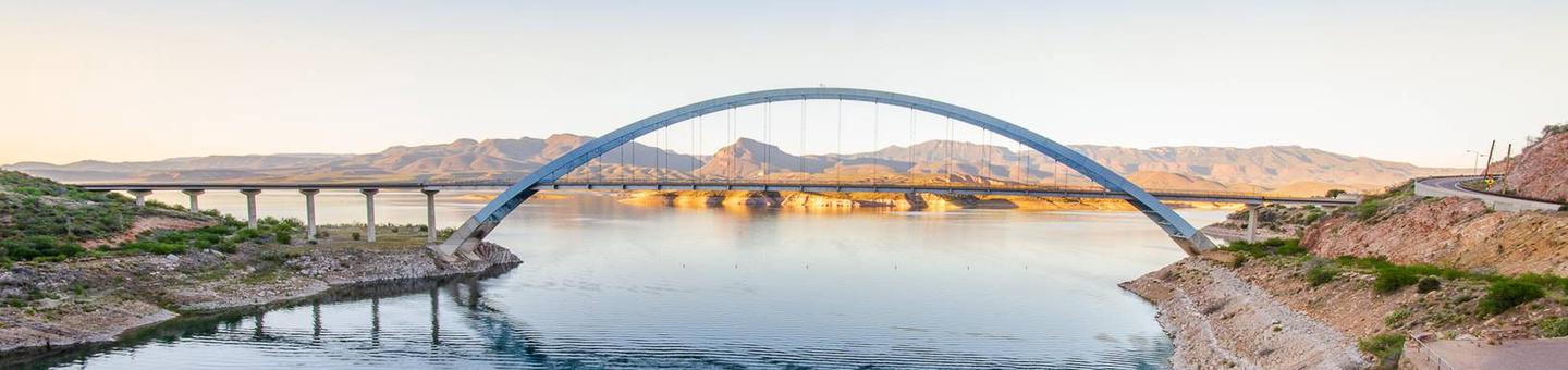
Roosevelt Lake was dedicated by President Theodore Roosevelt in 1911 and boasts 112 miles of shoreline and peaceful coves. When full, the lake provides 21,500 acres of surface water for your recreating pleasure. Cholla Campground is situated within a Sonoran Desert Landscape along the lakes shorelines. Views of the blue water and sunsets against the Sierra Ancha, Salome, and Superstition Wilderness’ are a sight that keep many visitors coming back year after year.
Nearby Attractions
Two National Scenic Byways (AZ Hwy 88 Apache Trail and AZ Hwy 288 Spines to Pines Highway). Roosevelt Dam, Tonto National Monument, the Arizona Trail, endless miles of jeep trails, Towns of Payson and Globe, Superstition, Sierra Ancha, and Four Peaks Wilderness’. Don’t forget to stop by the Tonto Basin Environmental Center learn about the history of the area.