CRYSTAL LAKE GROUP CAMPSITE, MT Campground Reservation, Info, Images, Map, Directions

CRYSTAL LAKE GROUP CAMPSITE, Montana Campground Images, Info & Reservations

Directions

From Lewistown, drive west on Montana Highway 200/US 87 for about 8 miles. Turn left (south) on Crystal Lake Road. Continue south, following the well-signed directions to the lake for 20 miles. At the "T" junction, turn left and continue on to Crystal Lake. The last 6 miles is paved and mostly a single lane. On December 1, the paved section is gated, and access beyond the gate is by snowmobile, skis, snowshoes or hiking only.

Phone

406-566-2292 OR 406-236-5511

Activities

BIKING, BOATING, HISTORIC & CULTURAL SITE, CAMPING, FISHING, HIKING, HORSEBACK RIDING, SWIMMING SITE

Keywords

Related Link(s)

Rec Area Info & Images

Montana State Tourism

Montana State Road Conditions

Overview

The Crystal Lake Group Campground is located in the beautiful Big Snowies south of Lewistown, Montana, at 5,700 feet. Home to the Crystal Lake recreation area, visitors enjoy hiking and fishing in the Snowies.

Recreation

The lake provides opportunities for swimming, fishing and canoeing. The various trails that stem from the Crystal Lake complex provide excellent views and interesting photo opportunities. One trail displays old hieroglyphs in a cave allowing visitors a glimpse of the past.

Facilities

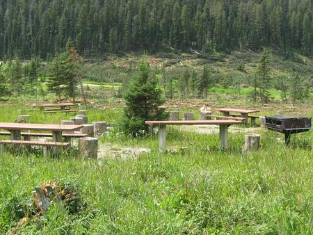
Water is available via a spring faucet and is just down from the camping site. An outhouse is provided next to the parking area for the group site. There is room for parking behind the gate in a parking area or to have two (up to 35) campers parked there as well. Asphalt walkways and tent pads are present but room in the adjacent meadow can be used for bigger tents. Two large picnic tables are on site and a metal fire ring.

Natural Features

Settled in the basin of Crystal Lake, the group site offers great access to trails and ta short drive or walk to the lake. Some trees are around the campsite but may not offer much shade.

Nearby Attractions

Ice Caves Trail, Cascade Trails and the lake are all located in the complex.

Reservation

More from CampingHiking.net:

PERRY SOUTH CAMPGROUND, Oregon Campground Images, Info & Reservations

Directions From Sisters, travel 5.6 miles northwest on Hwy 20. Continue 20.8 miles north on Forest Road 11, then 5.0 miles east on Forest Road 1170, and then 2.6 miles northwest of Forest Road 64. Phone 503-464-8515 Activities BIKING, BOATING, CAMPING, FISHING, HIKING, WATER SPORTS, WILDLIFE VIEWING, DAY USE AREA,

FRENCH GULCH, California Campground Images, Info & Reservations

Directions From Bakersfield, California, take Highway 178 east to the town of Lake Isabella. Turn onto Highway 155 north, following the western edge of the lake, for approximately 3 miles to the campground. Phone 760-376-1815 Activities CAMPING, PICNICKING Keywords FREG,LAKE ISABELLA,KERN VALLEY,SEQUOIA NF – FS Related Link(s) Rec Area Info

SMITH RIDGE, Kentucky Campground Images, Info & Reservations

Directions From Campbellsville, KY, take Highway 70 east for a mile. Turn right on Highway 372 and continue for 3 miles, then turn right again onto County Park Road. Follow the directional signs to the campground. Phone 270-789-2743 Activities BOATING, CAMPING, INTERPRETIVE PROGRAMS, FISHING, HIKING, HUNTING, PICNICKING, WILDLIFE VIEWING, DAY

Diamond Creek Guard Station, Idaho Campground Images, Info & Reservations

Directions From Soda Springs, take Highway 34 north approximately 12 miles to the China Hat turnoff (Blackfoot River Narrows). This road will follow Blackfoot River for another 11 miles to a junction; there is a Forest Service sign at this point. Take the right fork (Caribou National Forest Road 102)

BARTOO ISLAND GROUP SITE, Idaho Campground Images, Info & Reservations

Directions Campground is only reachable by boat. Travel north from Priest River, Idaho on State Highway 57 to various boat launches around the lake. To access the Kalispell Bay Boat Launch, travel on Highway 57 for 31 miles to Kalispell Bay Road. Turn east (right) until you reach West Lakeshore

SUMMIT VIEW CAMPGROUND, Utah Campground Images, Info & Reservations

Directions From Georgetown, Idaho, turn east on County Road 102. Travel two miles, and turn left on Forest Road 095 (the sign indicates the Left Fork of Georgetown Canyon). Continue about six miles, to the campground. Phone 541-351-1182 Activities BIKING, CAMPING, HIKING, HUNTING, WILDLIFE VIEWING, DAY USE AREA Keywords SUMM,CARIBOU-TARGHEE