AUK VILLAGE CAMPGROUND, AK Campground Reservation, Info, Images, Map, Directions

AUK VILLAGE CAMPGROUND, Alaska Campground Images, Info & Reservations

Directions

From the cruise ship terminal on South Franklin Street in downtown Juneau, head northwest along the waterfront. South Franklin Street becomes Marine Way, then Egan Drive, named for William A. Egan (1914 – 1984), first governor of the State of Alaska. Egan Drive becomes Glacier Highway at Milepost 9.4, then Juneau Veterans Memorial Highway from Milepost 12.1. At about 14 miles, exit west on Old Glacier Highway through Auke Village Recreation Area. Toward the end of the recreation area turn left on Pt. Louisa Road, and the campground entrance is on the left side of the road.

Phone

907-586-8800

Activities

BOATING, CAMPING, FISHING, HIKING, WILDLIFE VIEWING

Keywords

Related Link(s)

Rec Area Info & Images

Alaska State Tourism

Alaska State Road Conditions

Overview

Auk Village Campground is located 15 miles from downtown Juneau, Alaska, and 1.5 miles from the Alaska State Ferry terminal at Auke Bay. The area offers a variety of outdoor opportunities.

Recreation

The area offers fishing, wildlife viewing, kayaking, picnicking, motor boating, hiking, berry picking, rafting, sailing, bicycling, and glacier viewing.

Facilities

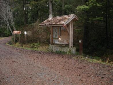
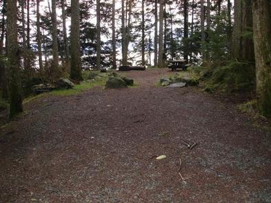
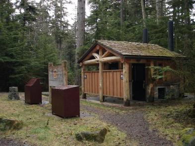
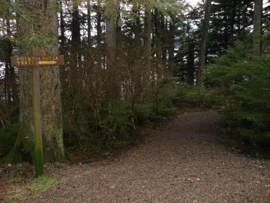
The campground offers 11 overnight campsites for tent and RV camping. Site sizes vary and range from 14′ to 35′. There is one central location that has a vault toilet, garbage cans, display board, and bear boxes. There are five drinking water spigots, a parking area for day use, and a dumpster. A trail starts at the parking lot that leads to the ocean and Pt. Louisa or to Auk Recreation Day Use area.

Natural Features

The campground sits above Auk Bay in a western hemlock and Sitka spruce forested area. Views of the Chilkat Range and the ocean are spectacular. Bears frequent the area.

Nearby Attractions

Auk Recreation Area includes a large day use area on the shores of Auk Bay. The area includes shelters, picnic tables, drinking water, fire rings and a trail. At the Auk Bay Harbor, commercial operators offer sport fishing, kayak rentals, and whale watching tours.

Reservation

More from CampingHiking.net:

YEGUA CREEK, Texas Campground Images, Info & Reservations

Directions From Austin, Texas, take US 290 east to Brenham. Follow HWY 36 north 11.5 miles to FM 1948. Turn left and follow FM 1948 2.5 miles. Turn right into park complex, following campground signs. From Houston, Texas, take HWY 290 west to Brenham. Follow HWY 36 north 11.5 miles

EEL CREEK CAMPGROUND, Oregon Campground Images, Info & Reservations

Directions From Reedsport, Oregon travel south 10 miles to the Eel Creek Campground. Campground entrance is located on west side of Highway 101 at mile post 222. Phone 541-271-6000 Activities CAMPING, FISHING, HIKING Keywords EELC,OREGON DUNES,LAKESIDE OREGON,TUGMAN STATE PARK,SIUSLAW NF – FS Related Link(s) Rec Area Info & Images Oregon

Grandview Shelter 2, West Virginia Campground Images, Info & Reservations

Directions To reach Grandview from Beckley follow I-64 East five miles to Exit 129 B. From Lewisburg follow I-64 West forty miles to Exit 129. From either exit, turn right and follow Route 9 North six miles to Grandview. Phone 304-465-0508 Activities HIKING, PICNICKING, DAY USE AREA Keywords Grandview State

SPRINGHILL, Arkansas Campground Images, Info & Reservations

Directions From Barling, Arkansas, take SR-59 north for 1.5 miles and follow signs into campground. Phone 479-452-4598 Activities BIKING, BOATING, CAMPING, FISHING, HIKING, BIRDING Keywords SPRH,JOHN PAUL HAMMERSCHMIDT LAKE,JOHN PAUL HAMMERSC Related Link(s) Rec Area Info & Images Arkansas State Road Conditions Arkansas State Tourism Overview Springhill Park sits along

NOTCH CABIN, Montana Campground Images, Info & Reservations

Directions Notch Cabin is about 62 miles from Ennis, Montana. The final 28 miles are gravel, dirt or primitive two-track. From Ennis, take Montana Highway 287 west for 23 miles to Alder. At Alder, turn south toward Ruby Reservoir (County 248) and travel 21 miles. Turn right on Ledford Creek

BREVOORT LAKE CAMPGROUND, Michigan Campground Images, Info & Reservations

Directions N4149 Brevort Camp Road Moran Michigan 49760 From St. Ignace, Michigan, take Highway 2 west for about 20 miles. Turn north on Brevort Camp Road/Forest Service Road 3108, then right at Forest Service Road 3473 and continue to the campground entrance. Phone 906-203-9872 Activities BIKING, BOATING, CAMPING, FISHING, HIKING,