


Directions
From the cruise ship terminal on South Franklin Street in downtown Juneau, head northwest along the waterfront. South Franklin Street becomes Marine Way, then Egan Drive, named for William A. Egan (1914 – 1984), first governor of the State of Alaska. Egan Drive becomes Glacier Highway at Milepost 9.4, then Juneau Veterans Memorial Highway from Milepost 12.1. About 14 mile exit west on Old Glacier Highway which brings you to Auke Village Recreation Area. The shelter is last one on the northwest end. Shelter number 5.
Phone
(907)586-8800
Activities
BOATING, CAMPING, FISHING, HIKING, VISITOR CENTER
Keywords
Related Link(s)
Overview
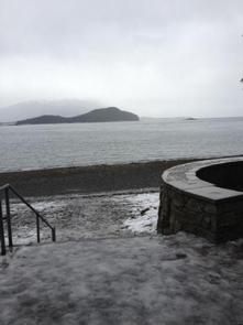
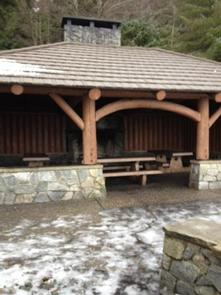
The Picnic Shelter #5 is part of the Auk Recreation Area and is located adjacent to a scenic beach on the northern shoreline of Auk Bay, once a village site for the Auk Tlingit Natives. It is the last shelter on the west end of the picnic area. It is the largest of the five shelters in the recreation area.
Recreation
The area offers fishing, water activities, picnicking, hiking, and berry picking.
Auk Recreation Area includes a large day use area on the shores of Auk Bay. The area includes five different shelters, picnic tables, drinking water, fire rings and a trail. At the Auk Bay Harbor commercial operators offer sport fishing, kayak rental, and whale watching tours.
Facilities
Shelter #5 has a maximum capacity of 40 people. The maximum group size allowed with this reservation is 74 people. Parking can be limited on sunny days due to crowds and is available above the shelter next to the highway (use caution loading and unloading). The shelter is accessed by a metal staircase or a fully accessible ramp. There are three picnic tables inside the shelter and a fire place. There are two grills next to the shelter, and a fire pit on the beach. There is a two-hole vault toilet a couple hundred feet from the shelter, and water spigot with city water on site. The path in front of the shelter leads to Auk Village Campground and Pt. Louisa. The opposite way leads to the restroom and another shelter.
Natural Features
The shelter overlooks Auk Bay and is surrounded by a western hemlock and Sitka spruce forested area.