


Directions
This Skater’s Cabin Shelter is approximately 13 miles from downtown Juneau. Access is via the Alaska Marine Highway or via Alaska Airlines.
By ferry: Turn right out of the Ferry Terminal parking lot. Drive 1.7 miles to DeHart’s Store above Auk Bay marinas. Take a left turn onto Back Loop Road. Travel 2.5 miles to Montana Creek Road. Turn left onto Montana Creek Road. Drive 0.4 miles to Skater’s Cabin Shelter. The shelter is just past the Mendenhall Lake Campground entrance.
From the airport: Go 0.1 mile to the junction of Yandukin Shell Simmons Drive. Turn left on Shell Simmons Drive and travel 0.3 miles to stoplight at the intersection of Old Glacier Highway. Turn left on Old Glacier Highway and travel 0.5 mile to the stoplight at the intersection of Egan Drive. Continue straight onto Mendenhall Loop Road 2.2 miles to the intersection of Back Loop Road. Turn left on Backloop Road. Continue 1.4 miles to the intersection of Montana Creek Road. Turn right and travel 0.4 miles to Skater’s Cabin Shelter. The shelter is just past the Mendenhall Lake Campground entrance.
Phone
(907)586-8800
Activities
BOATING, CAMPING, HIKING, VISITOR CENTER
Keywords
Related Link(s)
Overview
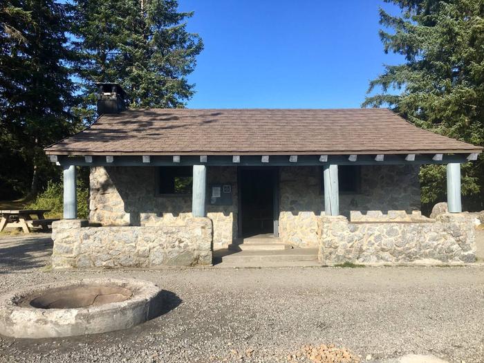
Skater’s Cabin Shelter is located on the shore of the southwest corner of Mendenhall Lake, near the Mendenhall Glacier. The cabin was constructed in 1936 by the Civilian Conservation Corps and is made with natural stone.
Recreation
The site is a popular destination for viewing beautiful scenery, biking, picnicking, and hiking.
Facilities
The Shelter has a maximum capacity of 20 people. The maximum group size allowed with this reservation is 74 people. The cabin is equipped with a covered porch and two movable picnic tables along with a wood stove. Outside facilities include a large group fire ring in front of the cabin and a stationary wood picnic table and a fire ring adjacent to the southwest corner of the cabin. The area is accessed by a trail that meets accessibility guidelines and leads to the beach.
A potable water hydrant and accessible vault toilets are also provided. The picnic area has two additional picnic sites with fire rings and tables designated for non-group use (they are not a part of this reservable site).
Natural Features
Skater’s Cabin is on the shore of Mendenhall Lake, in view of massive Mendenhall Glacier that is surrounded by mountains that rise from 4,000 to 7,000 feet above the glacier.