SANTIAM FLATS CAMPGROUND, OR Campground Reservation, Info, Images, Map, Directions

SANTIAM FLATS CAMPGROUND, Oregon Campground Images, Info & Reservations

Listen

Directions

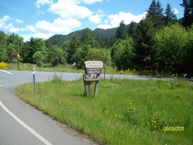
Travel 2.6 miles northeast of Detroit, Oregon. From Detroit, follow Highway 22 east for 2.6 miles to Blowout Road/Forest Service Road 10 on the right. Santiam Flats Campground in on the right.

Phone

503-854-3366

Activities

BOATING, FISHING, HIKING, SWIMMING, WATER ACTIVITIES

Keywords

Related Link(s)

Rec Area Info & Images

Forest Service Concessionaire

Oregon State Tourism

Oregon State Road Conditions

Overview

Santiam Flats Campground rests on the shores of the sparkling Detroit Lake. Visitors enjoy fishing, boating on the lake, and hiking on the nearby Stahlman Point Trail.

Recreation

Sailing, boating, water skiing and fishing are all excellent options for enjoying Detroit Lake. Catfish, rainbow trout and Kokanee salmon are among the most common species found in the lake.

Several hiking trails dot the area, including Stahlman Point Trail, which offers beautiful vistas of Detroit Lake and the surrounding area. The Hoover Nature Trail is an accessible, short footpath that delights many campers.

The Willamette National Forest has about 1,700 miles of trail. While many are in wilderness areas, a number of trails are low-elevation, easy-access trails for year-round hiking.

Facilities

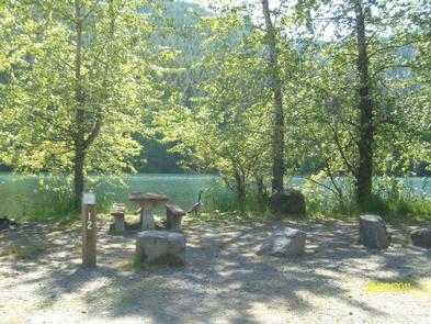
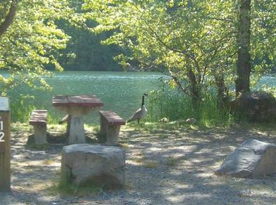
Sites have picnic tables, grills and easy access to the vault toilets. Drinking water spigots are spread throughout the campground. Most campsites offer views of the lake. Santiam Flats does not have a boat launch ramp. Some of the sites are adjacent to the shoreline and mooring is allowed.

Natural Features

The campground lies in the Willamette National Forest, which stretches for 110 miles along the western slopes of the Cascade Range. The varied landscape of high mountains, narrow canyons, cascading streams and wooded slopes offer varied recreational opportunities for visitors.

Nearby Attractions

Detroit Lake provides plenty of opportunity for water recreation like boating, water skiing and kayaking.

Reservation

More from CampingHiking.net:

Horsethief Group Sites, Utah Campground Images, Info & Reservations

Listen Directions From Moab, drive 9 miles north on Highway 191, turn west on Highway 313. Drive 12 miles and then turn right and drive in the short entrance road to the campground. Phone 435-259-2100 Activities AUTO TOURING, BIKING, CAMPING, HIKING, PHOTOGRAPHY, MOUNTAIN BIKING, STAR GAZING, SCENIC DRIVE Keywords Related

BIDWELL POINT PARK, Arkansas Campground Images, Info & Reservations

Listen Directions From Mountain Home, AR, travel 9 miles east on US 412/62, then 2 miles north on SR 101. Cross the lake on 101 bridge and take the 1st access road to the right. Follow signs into campground. Phone 870-467-5375 Activities CAMPING, HIKING, SWIMMING SITE Keywords BIDW,NORFORK LAKE,NORFORK LAKE

PINE ISLAND GROUP AREA, Wyoming Campground Images, Info & Reservations

Listen Directions Located 27 miles west of Dayton, Wyoming, on U.S. Highway 14. Phone 406-587-9054 Activities BIKING, BOATING, CAMPING, FISHING, HIKING, WILDLIFE VIEWING Keywords PIIS,PINE ISLAND,BIGHORN NF – FS Related Link(s) Rec Area Info & Images Overview Pine Island Group Area is located along the Bighorn Scenic Byway (U.S. Highway

UPPER COFFEE POT, Idaho Campground Images, Info & Reservations

Listen Directions From West Yellowstone, Montana, take Highway 20 south for 23 miles. From Ashton, Idaho, take Highway 20 north for 32 miles. Turn west onto Forest Road 130 and travel 2 miles to the campground. Phone 208-558-7658 OR 208-270-0094 Activities BOATING, CAMPING, FISHING, HIKING, WILDLIFE VIEWING Keywords UPCP,Coffee Pot,CARIBOU-TARGHEE