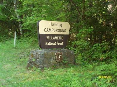
HUMBUG CAMPGROUND, OR Campground Reservation, Info, Images, Map, Directions

HUMBUG CAMPGROUND, Oregon Campground Images, Info & Reservations

Directions

4.6 miles northeast of Detroit, Oregon. From Highway 22 at Detroit, turn east onto Breitenbush Road/Forest Service Road 46 and continue for 4.6 miles to Humbug Campground on the right.

Phone

503-854-3366

Activities

FISHING, WATER ACTIVITIES

Keywords

Related Link(s)

Rec Area Info & Images

Oregon State Road Conditions

Forest Service Concessionaire

Oregon State Tourism

Overview

Humbug Campground is surrounded by old-growth forest, and during the months of May through July, the rhododendrons bloom in a spectacular show of pink blossoms. Recreation in the area is abundant — plan on a quiet stroll through this lush forest or fishing on nearby Breitenbush River.

Recreation

Wading and fishing are popular activities in the Breitenbush River, and rainbow trout is the most common catch for anglers.
The Willamette National Forest has about 1,700 miles of trail. While many are in wilderness areas, a number of trails are low-elevation, easy-access trails for year-round hiking.

Facilities

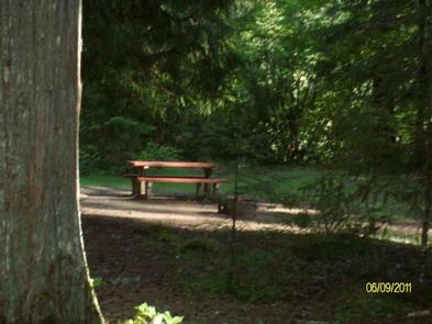
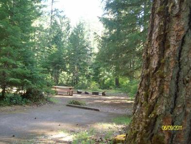
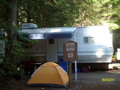
Humbug Campground sites have picnic tables, grills and easy access to the vault toilets. Drinking water spigots are spread throughout the campground. Most campsites offer sweeping views of the river.

Natural Features

The campground lies in the Willamette National Forest, which stretches for 110 miles along the western slopes of the Cascade Range. The varied landscape of high mountains, narrow canyons, cascading streams and wooded slopes offer varied recreational opportunities for visitors.
The Breitenbush River is a tributary of the North Santiam River, and its clean waters flow from short forks of snowmelt in the Mount Jefferson Wilderness.
A variety of plants and foliage separate the spacious campsites and provide privacy from other sites.

Nearby Attractions

Detroit Lake has a marina and provides plenty of opportunity for water recreation like boating, water skiing and kayaking.

Reservation

More from CampingHiking.net:

MCKENZIE BRIDGE, Oregon Campground Images, Info & Reservations

Directions From Eugene, OR, take I-105 east to McKenzie Highway 126 for 55 miles. Look for signs. The campground is located on the right side of the highway. Phone 801-226-3564 Activities FISHING, KAYAKING, RAFTING Keywords MCKE,WILLAMETTE NF -FS Related Link(s) Rec Area Info & Images Forest Service Concessionaire Oregon State

SUGAR BOTTOM, Iowa Campground Images, Info & Reservations

Directions From Interstate 380 (North Liberty, Iowa), take Exit 4 towards North Liberty. Travel east on W. Penn St. for 2.2 miles. At the four way stop sign, turn left onto N. Front St./Mehaffey Bridge Rd. NE. Continue traveling on Mehaffey Bridge Rd. NE for 2.9 miles. Right after crossing

COLES CREEK DAY USE, Illinois Campground Images, Info & Reservations

Directions From I-57, take Old U.S. Highway 50 west for 19 miles, through Salem, Odin and Sandoval. Turn north on Boulder Road/2400E and continue for 4 miles, then turn east on 1700N and continue until the road connects with 2400E. Continue south to the Coles Creek entrance. Phone 618-226-3211 Activities

OSPREY, Idaho Campground Images, Info & Reservations

Directions From I-90, turn at Post Falls Highway 41 north to Newport. Take Highway 2 east to Priest River at the junction of Highway 57 and Highway 2. Turn left at the Texaco station on Highway 57 and drive 25 miles to Outlet Bay Road. Turn right for approximately 0.5

FISH CREEK (OR), Oregon Campground Images, Info & Reservations

Directions From Estacada, travel east on Highway 224 for approximately 16 miles. Phone 503-630-5721 Activities BIKING, BOATING, CAMPING, FISHING, HIKING, WATER SPORTS Keywords FLI1,MT. HOOD NF – FS Related Link(s) Rec Area Info & Images Oregon State Road Conditions Forest Service Concessionaire Oregon State Tourism Overview Fish Creek Campground is