BULL BEND CAMPGROUND, OR Campground Reservation, Info, Images, Map, Directions

BULL BEND CAMPGROUND, Oregon Campground Images, Info & Reservations

Directions

From Bend, OR: Travel 26.8 miles south on Highway 97 to Wickiup Junction, then 10.5 miles west on County Road 43, turn left on the 100 road. There is a sign there for Bull Bend. Follow the 100 road south approximately one mile and turn left at the sign which directs you to Bull Bend. Travel east about 1.5 miles until the road dead ends. Make a left and then in about a quarter mile you will turn right into the campground.

Phone

541-323-1746

Activities

CAMPING

Keywords

Related Link(s)

Rec Area Info & Images

Oregon State Tourism

Oregon State Road Conditions

Overview

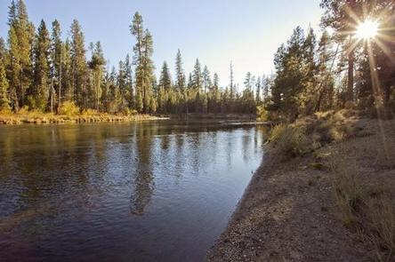
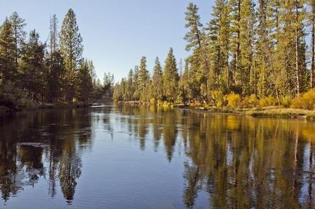
Bull Bend is located along the Deschutes River just below the Wickiup Reservoir Dam.

Recreation

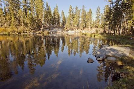
Bull Bend Campground offers a great location for fishermen. Fishing access is best found along the banks or using a non-motorized boat. Motorized boating is not permitted in the area.

Facilities

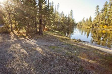
Bull Bend Campground can accommodate RV, trailer or tent-campers; however, electric and water hookups are not available. The campground does not have running water. All sites are equipped with a picnic table and fire pit. Vault toilets are available.

Natural Features

Bull Bend Campground is located on a small peninsula lined by the Deschutes River.

Nearby Attractions

Visitors can explore wilderness areas, rivers, lakes and reservoirs, and hundreds of miles of hiking trails. Newberry National Volcanic Monument offers a glimpse into Central Oregon’s rich geologic history. Travel 25 miles to Lava Lands Visitor Center to explore exhibits at the interpretive center, attend a ranger talk, take in scenic views from the top of Lava Butte and travel one-mile underground through Lava River Cave. Travel 30 miles to Newberry Caldera to visit Paulina and East Lake, Paulina Peak and Paulina Falls. Bull Bend Campground offers easy access to the Cascade Lakes Scenic Byway which weaves through multiple high lakes with views of South Sister, Broken Top and Mt. Bachelor.

Reservation

More from CampingHiking.net:

GILL POINT, South Carolina Campground Images, Info & Reservations

Directions From Lincolnton, GA, travel approximately 12 miles north on SR-79. Phone 800-5333478 Activities BOATING, DAY USE AREA, SWIMMING SITE, ACCESSIBLE SWIMMING Keywords GILL,J STROM THURMOND LAKE Related Link(s) Rec Area Info & Images Georgia State Tourism Georgia State Road Conditions Overview Gill Point Recreation Area is a rural park

OLD HICKORY BEACH, Tennessee Campground Images, Info & Reservations

Directions From Nashville, take I-65 North to exit 92, TN-45/Old Hickory Blvd toward Madison, continue until you cross over the Cumberland River then take the 2nd left onto Bridgeway Ave., travel approximately 0.2 miles and turn left onto Ensley Ave., continue approximately 0.3 miles and turn left onto Swinging Bridge

PAULSON BAY CABIN, Alaska Campground Images, Info & Reservations

Directions To access the cabin by float plane: it is 40 minutes from Anchorage and 60 minutes from Cordova. By boat, the trip is 18 miles from Whittier. Note: the Bay is not obvious because the mouth is partially obscured by five small islands. Beware of submerged rock ledges between

BAY VIEW, Michigan Campground Images, Info & Reservations

Directions 19456 W Lakeshore Drive, Brimley MI 49715 From Brimley, Michigan, travel west on County Road 42/Whitefish Bay Scenic Byway for approximately 8 miles. Bay View is on the north side of the road. Phone 906-203-9872 Activities HISTORIC & CULTURAL SITE, CAMPING, HIKING, SWIMMING SITE Keywords BYVW,Superior Lake Campground,Lake Superior

OWEN CREEK, Wyoming Campground Images, Info & Reservations

Directions From Dayton, Wyoming: Travel 27 miles on U.S. Highway 14 west, turn left (south) at Burgess Junction and continue on Hwy 14 for 5 miles until you reach Forest Road 236. Take a right on Forest Road 236 and continue about .2 miles to the campground. Phone 406-587-9054 Activities