SHERWOOD CAMPGROUND, OR Campground Reservation, Info, Images, Map, Directions

SHERWOOD CAMPGROUND, Oregon Campground Images, Info & Reservations

Directions

From I-84 at Hood River, head south on highway 35 toward Mt. Hood. Just past the Tamanawas Falls trailhead parking, the Sherwood Campground is on the right.

Phone

541-386-6366

Activities

CAMPING

Keywords

Related Link(s)

Rec Area Info & Images

Oregon State Road Conditions

Oregon State Tourism

Overview

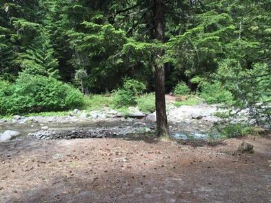
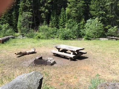
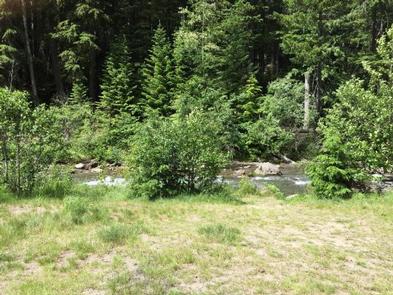
Sherwood campground is an easily accessible location for simple camping, with beautiful landscapes and the Hood River rushing next to it. Close to hiking and recreational locations, Sherwood campground is a prime location for those looking for a centrally located base camp near Mt. Hood, or for those looking for a surprisingly quiet, camping getaway.

Recreation

The location of Sherwood Campground makes for a great place to set up camp and explore the upper Hood River Valley. Hiking trails, waterfalls, river and creeks are in abundance, and with easy access to both Hood River and Mt. Hood, tourist attractions, museums and adventures await.

Facilities

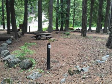
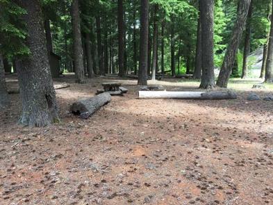
Sherwood campground is a small campground, with an unexpected charm. It sits right along highway 35, so you can see it as you drive by. The rush of the river that sits next to the campground blocks all traffic sounds from the highway. Pit toilets are located centrally in the campground, making it easy to access. A camp host is available during peak season.

Natural Features

With the Upper Hood River running next to the campground, the nearby traffic is drowned out, and a peaceful retreat is found. Several of the campsites are right on the river, and the beautiful areas that the river has etched is fun to explore.

Nearby Attractions

The Sherwood Campground sits near many locations that are easily accessible in the Mt. Hood area. Campers can walk along highway 35 a couple hundred feet to the Tamanawas Falls trailhead for a beautiful, popular hike. Also, Mt. Hood is only a 15-minute drive from the campground, which has various hiking, biking, and adventure centers for recreationalists.

Reservation

More from CampingHiking.net:

SPRING CANYON, Washington Campground Images, Info & Reservations

Directions Take State Highway 2 west of Spokane for 65 miles to the town of Wilbur, Washington. Turn north on State Highway 174 (follow road signs). Travel 19 miles and turn right at the sign for Spring Canyon Campground. Phone 509-754-7889 Activities BIKING, BOATING, HISTORIC & CULTURAL SITE, CAMPING, INTERPRETIVE

TRIAL LAKE CAMPGROUND, Utah Campground Images, Info & Reservations

Directions From Salt Lake City, Utah, take I-80 east for approximately 30 miles to Exit 146 for Highway 40 toward Park City/Heber City/Vernal. Take Exit 4 onto Highway 248 toward Kamas. Take left onto UT 32 then right onto Highway 150 (Mirror Lake Scenic Byway). Go 25 miles to campground.

HOUSTON MESA, Arizona Campground Images, Info & Reservations

Directions From Payson, Arizona, go north for 1 mile to the junction of Highway 87 (Beeline Highway) and Forest Road 199 (Houston Mesa Road). Turn right (east) onto Forest Road 199 for .10 miles. The campground is on the north side of Houston Mesa Road. Phone 928-468-7135 Activities CAMPING, HIKING,

EAGLE ROCK, Missouri Campground Images, Info & Reservations

Directions From Cassville, Missouri, take US-86 southeast for 4 miles to Eagle Rock Community to the access road. Follow the signs into the campground. Phone 417-271-3215 Activities BIKING, BOATING, CAMPING, FISHING, HIKING, PICNICKING, WATER SPORTS, WILDLIFE VIEWING, DAY USE AREA, SWIMMING SITE, PHOTOGRAPHY, DIVING, RANGER STATION, KAYAKING, WATER ACCESS Keywords

COWPUNCHER GUARD STATION, Utah Campground Images, Info & Reservations

Directions From Highway 12 in Escalante, turn north on 300E. Drive 14 miles to the junction of Forest Roads 154 and 153. Continue on FR153 for 4.5 miles. Turn left on FR145 towards Cowpuncher and Blue Spruce Campground. Travel 0.7 miles to Cowpuncher Gate. The cabin is 0.2 miles past

LONGVIEW, Kansas Campground Images, Info & Reservations

Directions From Perry, Kansas, go 8 miles north on Ferguson road, then 2 miles west on 86th street and follow signs to the campground. Phone 785-597-5144 Activities BIKING, BOATING, CAMPING, FISHING, HIKING Keywords LONV,LAKE PERRY,PERRY RESERVOIR,APPLE VALLEY FARM,PERRY LAKE Related Link(s) Rec Area Info & Images Kansas State Tourism Kansas