Directions
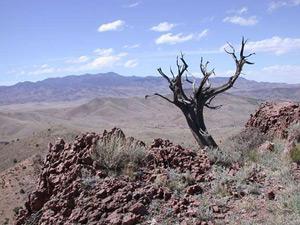
Chupadera Peak, Indian Wells, and Little San Pascual Wilderness Areas are all located on Bosque del Apache National Wildlife Refuge, approximately 16 miles south of Socorro, New Mexico. To get here, travel approximately 8 miles south of Socorro on I-25. Take Exit 139 and travel east on Hwy 380 to San Antonio. Turn south on Hwy 1 approximately 8 miles to the Refuge Visitor Center. There you can recieve information and directions on how to access the Wilderness Areas and Refuge Regulations.
Phone
575-835-1828
Activities
WILDERNESS
Camping Reservations
Reserve your campsite at these camping areas:
Hiking Trails
Looking for nice hiking areas to take a hike? Choose from these scenic hiking trails:
Related Link(s)
More New Mexico Recreation Areas
Bosque del Apache Wilderness Map
Bosque Del Apache National Wildlife Refuge
The Bosque del Apache Wilderness now contains a total of 30,427 acres and is managed by the U.S. Fish & Wildlife Service Bosque Del Apache National Wildlife Refuge. All of the Wilderness is in the state of New Mexico. In 1975 the Bosque del Apache Wilderness became part of the now over 110 million acre National Wilderness Preservation System.
Bosque del Apache NWR has three Wilderness Areas. They are the 5,429-acre Chupadera Wilderness, all refuge land west of Interstate 25; the 5,139-acre Indian Well Unit, just across the interstate from the Chupadera Wilderness; and the Little San Pascual Wilderness, which covers 19,859 acres just east of the Rio Grande.


