Directions
Lacassine National Wildlife Refuge is located at 209 Nature Road, at the end of Highway 3056, eleven miles southwest of Lake Arthur, Louisiana off Hwy. 14. The office is open year round, weekdays only, from 7:30 a.m. to 4:00 p.m., excluding federal holidays. Portions of the refuge are open year round from one hour before sunrise until one hour after sunset. Please consult refuge brochures or contact the refuge office for more details. Vicinity and refuge maps are available. Check out the exact location of the wilderness using the following Wilderness map. Lat: 29°55’52.24″N Long: 92°52’54.74″W
Phone
337-598-2216
Activities
WILDERNESS
Camping Reservations
Reserve your campsite at these camping areas:
Hiking Trails
Looking for nice hiking areas to take a hike? Choose from these scenic hiking trails:
Related Link(s)
More Louisiana Recreation Areas
The Lacassine Wilderness now contains a total of 3,346 acres and is managed by the Fish & Wildlife Service Southwest Louisiana National Wildlife Refuge Complex. All of the Wilderness is in the state of Louisiana. In 1976 the Lacassine Wilderness became part of the now over 110 million acre National Wilderness Preservation System.
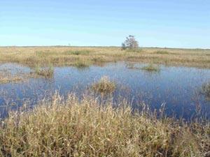
On the southern end of the Mississippi and Central Flyways, Lacassine National Wildlife Refuge is primarily a freshwater marsh. Lacassine refuge marshes provide feeding and resting habitat for more than 300,000 ducks and 80,000 geese. The refuge also provides habitat for many shorebirds, wading birds, marsh birds, various manmmals,and alligators. The first nesting colony of cattle egrets outside Florida was discovered here. Nesting rookeries of roseate spoonbills, and other wading birds can be found in the Lacassine Pool. Watch for armadillos, swamp rabbits, minks, otters, nutrias and American alligators. The southern portion of the refuge, south of the pipeline canal and west of Bayou Misere, has been designated Wilderness. Unlike the rest of the refuge, this area has seen relatively little impact from human activity. There are no established trails, and no camping is allowed. The 3345 acre wilderness area can be accessed by non-motorized vessel or chest waders.
The name Lacassine comes from the local native American word “loc o’shin”, which means “at the prairies edge”.