Directions
With the exception of the Big Wash Road Access, 4-wheel drive is recommended for all described access routes. High clearance vehicle required for all routes.
Antelope Canyon Access: Turn east onto the Pierce Ferry Road from Highway 93 at milepost 42. Proceed north and east through Dolan Springs to 19th Street. Turn right on 19th Street and proceed for 0.6 miles. Turn right on Ocotillo Drive and proceed for 1.0 mile. Turn left on 17th Street and proceed for 0.2 miles. Turn right on Orchid Street and proceed 0.5 miles. Turn left onto 16th Street (no sign) and proceed one block. Turn right onto Palm Street and proceed 0.5 miles, at which point you have reached the wilderness boundary. A jeep trail continues south another 1.5 miles along the boundary to a parking area. A small half mile interpretive loop trail is located at the parking area outside of the designated wilderness area. The trail is best for either hiking or equestrian use.
Indian Springs Access: Turn east onto the Pierce Ferry Road from Highway 93 at milepost 42. Proceed 1.5 miles toward Dolan Springs and turn right onto 5th Street. Follow this road for about 4.5 miles until you run into a fence. Turn left, following the fence, for about 0.1 mile, and turn right through the gate in the fence. Follow this jeep road for 0.8 mile to the parking area.
Marble Canyon Access: Proceed to milepost 48 on Highway 93. Go through the gate on the east side of the highway onto a jeep trail. Follow this jeep trail, which bypasses a corral and water tank, and then parallels a wire fence, for about 0.7 miles. Go through the gate in the fence and follow the trail another 2 miles, bearing right at one point where an obscure fork in the road exists. Proceed through another gate. Another 0.25 mile further on, take the left fork in the road. Proceed another 0.5 mile, at which point you have reached the wilderness area. Parking is at your discretion along this road, keeping in mind that the wilderness area is to either side of you, 30 feet off of the road.
Big Wash Road Access: Proceed to milepost 51 on Highway 93. Turn east onto a maintained dirt road, known as the Big Wash Road, for about 4.5 miles. At this point, the wilderness area will be on your left. Parking along the Big Wash Road is at your discretion– be sure not to create a hazard to other traffic.
Phone
(928) 718-3700
Activities
CAMPING, HIKING, HORSEBACK RIDING, WILDERNESS, PHOTOGRAPHY
Camping Reservations
Reserve your campsite at these camping areas:
Hiking Trails
Looking for nice hiking areas to take a hike? Choose from these scenic hiking trails:
Related Link(s)
Overview
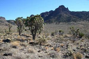
The 30,760-acre Mount Tipton Wilderness is located in Mohave County, 25 miles north of Kingman, Arizona. This wilderness includes the entire northern half of the imposing Cerbat Mountains. Although Mount Tipton Peak, at 7,148 feet, dominates the wilderness, the true centerpiece and main scenic attraction here is the Cerbat Pinnacles. Located north of and below Mount Tipton, the Pinnacles, immense tusk-like rows of maroon-colored spires, stand majestically above open, tawny-colored valleys.
Large and topographically complex, the Mount Tipton Wilderness provides a wide range of hiking, backpacking, photography, and horseback riding opportunities. Visitors capable of making the climb to the top of Mount Tipton can examine a remnant stand of large ponderosa pine located below the peak to the northeast, and will enjoy unsurpassed views in all directions.
Know Before You Go
- A four-wheel drive vehicle is strongly recommended to gain access to this wilderness.
- The terrain in Mt. Tipton is extremely rugged. A few old vehicle ways provide hiking routes in some places, but the most commonly used routes are the sand washes which dissect the area.
- The summer climate in this area is harsh, with temperatures in the daytime often exceeding 100 degrees. Temperatures are more moderate between October and April. During winter months it can be quite cold and snow is possible at the higher elevations.
- Water is relatively scarce in this part of the Cerbat Mountains. Springs shown on topographic maps can generally be relied upon for drinking water. Following rainy weather, pothole water is available, but can dry up quickly. Purification of all water is a necessity.
- Please follow the regulations in place for this area, and use Leave No Trace techniques when visiting to ensure protection of its unique natural and experiential qualities.
- Motorized equipment and equipment used for mechanical transport are generally prohibited on all federal lands designated as wilderness. This includes the use of motor vehicles (including OHVs), motorboats, bicycles, hang gliders, wagons, carts, portage wheels, and the landing of aircraft including helicopters. Contact the agency for more information about regulations.
- Some lands around and within the wilderness are not federally administered. Please respect the property rights of the owners and do not cross or use these lands without their permission.


