Directions
From Needles, CA, take U.S. Highway 95 south approx. 35 miles to BLM Route NS634-Mopah Trail. Turn right on NS634 and drive approx. 2 miles. A wilderness kiosk sign will be on your left hand side.
Phone
760-326-7000
Activities
CAMPING, HIKING, HORSEBACK RIDING, HUNTING, WILDLIFE VIEWING, WILDERNESS, PHOTOGRAPHY
Camping Reservations
Reserve your campsite at these camping areas:
Hiking Trails
Looking for nice hiking areas to take a hike? Choose from these scenic hiking trails:
Related Link(s)
More California Recreation Areas
Turtle Mountains Wilderness Map
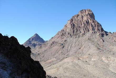
The Turtle Mountains Wilderness area ranges from broad bajadas to highly eroded volcanic peaks, spires, and cliffs. The Mopah Range contains the two signature Mopah Peaks, which are rhyodactic or volcanic plugs. The northern most peak is a landmark known as Mexican Hat. The area has numerous springs and seeps. Much of the Turtle Mountain range has been designated as a National Natural Landmark in recognition of its exceptional natural values.
Dominate vegetation consists of the creosote bush-bur sage and the palo verde-cactus shrub ecosystems. In the washes, Colorado/Sonoran microphylla woodlands can be found. These woodlands include such things as palo verde, smoke tree, honey mesquite, and catclaw. Wildlife species include bighorn sheep, coyote, black-tailed jackrabbits, ground squirrels, kangaroo rats, quail, roadrunners, golden eagles, prairie falcons, rattlesnakes, and several species of lizards. The desert tortoise is found within the wilderness area, and northwestern and northeastern portions of the wilderness area are considered critical habitat. The wilderness is located in the southern portion of the sector and consists of 177,209 acres. OHV activity is common along the boundaries of wilderness.


