Directions
From Needles, CA, take I-40 west approx. 10 miles to the U.S. Highway 95 north exit. Exit north and take U.S. Highway 95 approx. 45 miles to NV State Route 164 (Searchlight, NV). Turn left on SR 164 and drive approx. 20 miles to the CA/NV state line. The road turns into Nipton Road. Drive on Nipton Road approx. 15 miles to I-15. Take I-15 west approx. 15 miles to Cima Road. Turn right at the Cime Road exit and take Excelsior Mine/Kingston Road north approx. 12 miles. A wilderness kiosk sign will be on your right hand side.
Phone
760-326-7000
Activities
CAMPING, HIKING, HORSEBACK RIDING, HUNTING, WILDLIFE VIEWING, PHOTOGRAPHY
Camping Reservations
Reserve your campsite at these camping areas:
Hiking Trails
Looking for nice hiking areas to take a hike? Choose from these scenic hiking trails:
Related Link(s)
More California Recreation Areas
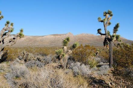
The North Mesquite Mountains Wilderness consists of the broad western end of Sandy Valley and the northern portion of Mesquite Mountains. Rolling brown foothills, a few steeper mountains, and medium sized buttes comprise the reddish-brown geologic features in the wilderness. Dominant vegetation includes creosote brush scrub, blackbush, Joshua tree woodland, yucca, cacti, and some grasses. Wildlife is also typical for the Mojave Desert. Due to the lack of naturalwaters, bighorn sheep do not inhabit the area on a permanent basis but do transverse the area. The southern tip of the wilderness provides critical habitat for the desert tortoise. The wilderness is located in the northeastern portion of the sector and consists of 28,955 acres.