Directions
From Enterprise, Oregon: Drive west 31 miles on State Highway 82. The highway crosses the Wallowa River at Minam, Oregon.
Phone
541-473-3144
Activities
CAMPING, FISHING, HIKING, HUNTING, WILDLIFE VIEWING, PADDLING, SWIMMING
Camping Reservations
Reserve your campsite at these camping areas:
Hiking Trails
Looking for nice hiking areas to take a hike? Choose from these scenic hiking trails:
Related Link(s)
Interactive Video: 360° video along the Wallowa River
Wallowa Wild and Scenic River at rivers.gov
Overview:
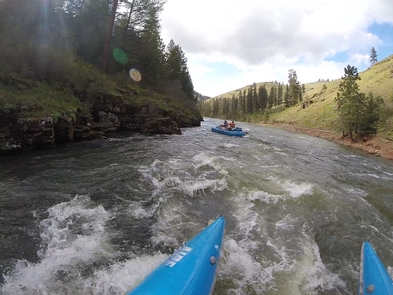
Each year, the Wallowa Wild and Scenic River receives thousands of visitors seeking the beauty and diverse recreation opportunities that the river offer. Where road and trail access is most limited, well-prepared whitewater boaters travel the river using a variety of specialized watercraft. A typical float trip begins at Minam on the Wallowa River and lasts two to three days, taking out on the Grande Ronde River downstream.
Peak recreational boating season is between April and August, although river trips are possible throughout the year, depending on river conditions. Because the rivers are primarily free-flowing, water levels and river character changes dramatically with the seasons and local weather. Higher, faster river flows typically occur in the spring and early summer, as warmer temperatures and increased rainfall melt high mountain snows. As the season progresses, the river level gradually drops. By August, river flows are typically very low, with shallow water and exposed rocks being common. Low water levels usually remain throughout the fall and winter months. Boaters are strongly advised to obtain up-to-date river conditions and weather forecasts when planning their trip. Visitors wishing to avoid crowds should plan their trip to avoid weekends and holidays if possible.
Know Before You Go:
- Every boating party must obtain a Self-Issue River Permit prior to launch, available at most public river access points. Permits are free,and do not restrict number of trips you make, or limit trip itineraries. Contact the BLM for more details-see contact information on sidebar.
- Primitive, undeveloped river camping is available on a first-come, first-serve basis. Visitors are required to follow low impact, Leave-No-Trace practices to minimize the traces of their stay and help preserve the natural resources.
- Vehicle shuttle routes often include rough roads, and may require good map reading skills and/or GPS to follow. Some roads may be unmaintained or impassable inquire locally for current conditions. Gasoline, food, and other services are often not available in rural areas. Cell phone service is generally not available in the remote, rugged terrain of the river corridor. Drivers should be well prepared, and carry extra fuel, food, water, and a spare tire. For safety, always tell someone where you are going and when you expect to return.
- For a developed camping experience, check out Minam Recreation Area 2 miles north of Minam, Oregon. Campsites are available year-round on a first-come, first-served basis.
- Don’t Move Firewood: Please protect Pacific Northwest forests by preventing the spread of invasive species. Firewood can carry insects and diseases that can threaten the health of our western forests. You can make a difference by obtaining and burning your firewood near your camping destination.
Point of Interest:
Completed in 1908, the rail line known as the “Joseph Branch” transported goods and people, shutting down in the early 2000s. Today, one can get a close-up view of the Wallowa River on the seasonally-operated Eagle Cap Excursion Train, a heritage railroad service.


