Directions
The site is located 17 miles north of Tularosa, NM, and 28 miles south of Carrizozo, NM on U.S. 54. Turn east from U.S. 54 at Three Rivers onto County Road B30 and travel five miles on paved road, following signs.
Phone
(575) 525-4300
Activities
HISTORIC & CULTURAL SITE, CAMPING, HIKING, PICNICKING, RECREATIONAL VEHICLES
Camping Reservations
Reserve your campsite at these camping areas:
Hiking Trails
Looking for nice hiking areas to take a hike? Choose from these scenic hiking trails:
Related Link(s)
More New Mexico Recreation Areas
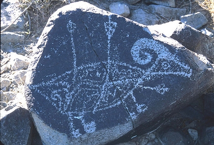
The Three Rivers Petroglyphs are outstanding examples of prehistoric Jornada Mogollon rock art. The basaltic ridge rising above the Three Rivers Valley contains over 21,000 petroglyphs, including masks, sunbursts, wildlife, handprints, and geometric designs. The number and concentration of petroglyphs make this one of the largest and most interesting rock art sites in the Southwest. A rugged 0.5-mile trail begins at the visitor shelter and links many of the most interesting petroglyphs. Another short trail begins on the east side of the picnic area and leads to a partially excavated prehistoric village.
The Three Rivers Petroglyph Site is one of the few locations in the Southwest set aside solely because of its rock art. It is also one of the few sites giving visitors such direct access to petroglyphs. The number and concentration of petroglyphs here make it one of the largest and most interesting petroglyphs sites in the Southwest. More than 21,000 glyphs of birds, humans, animals, fish, insects and plants, as well as numerous geometric and abstract designs are scattered over 50 acres of New Mexico’s northern Chihuahuan Desert. The petroglyphs at Three Rivers, dating back to between about 900 and 1400 AD, were created by Jornada Mogollon people who used stone tools to remove the dark patina on the exterior of the rock. A small pueblo ruin is nearby and Sierra Blanca towers above to the east. A detailed petroglyph guide is available at the Three Rivers Petroglyph Site.


