LONE ROCK (CA), CA Campground Reservation, Info, Images, Map, Directions

LONE ROCK (CA), California Campground Images, Info & Reservations

Listen

Directions

Take Arlington Road off Highway 89 (near Crescent Mills) to Taylorsville Road, continuing on Genesee Road and Indian Creek Road to Antelope Lake.

Phone

530-283-0555

Activities

BIKING, BOATING, CAMPING, INTERPRETIVE PROGRAMS, FISHING, SWIMMING SITE

Keywords

LON1,ANTELOPE LAKE,SUSANVILLE,TAYLORSVILLE,JANESVILLE,PLUMAS NF – FS

Related Link(s)

Rec Area Info & Images

California State Tourism

California State Road Conditions

Forest Service Concessionaire

Overview

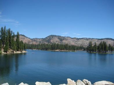
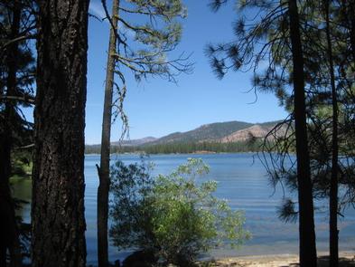
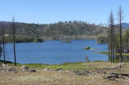
Lone Rock Campground is one of three in the Antelope Lake Recreation Area. Nestled in the beautiful northern Sierra Nevada mountain range, it offers forested woods and scenic vistas as far as the eye can see.

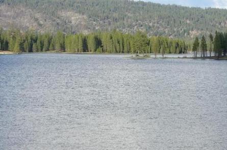
Antelope Lake is one of the more remote, quiet lakes in the Plumas National Forest, making it a popular destination for anglers and explorers of all abilities.

Recreation

The campground’s close proximity to the lake provides visitors with access to fishing, swimming, boating, water skiing and other water-related recreation activities. Anglers can look forward to a well-stocked trout, bass and catfish population.

Educational programs are offered at the campground’s amphitheater. Hiking and mountain biking opportunities abound. The Sunset Point trail begins near the campground.

Facilities

The campground offers multiple sites for both tent and RV camping, several of them adjacent to the lake, providing views of the lake. Space allows for two vehicles at each site; extra vehicles can be parked in nearby overflow parking at no extra charge.

Tables and campfire rings with grills are provided, as well as vault toilets and drinking water.

Natural Features

Tall pine and fir trees provide plentiful shade to the area, which is situated at an elevation of 5,000 feet.

Nearby Attractions

The campground is 30 miles from the small town of Taylorsville. The drive along Janesville Grade has some terrific views.

Reservation

More from CampingHiking.net:

OLD FEDERAL, Georgia Campground Images, Info & Reservations

Listen Directions Take I-85 north to I-985, take Exit 8, turn left on Hwy 347/Friendship Rd., turn right on McEver Rd., turn left on Jim Crow Rd. and follow signs to the campground. Phone 770-967-6757 Activities BIKING, BOATING, CAMPING, FISHING, PICNICKING, SWIMMING SITE, SWIMMING, WATER ACTIVITIES, WATER ACCESS Keywords OLDF,LAKE

MINGUS RANCH, Colorado Campground Images, Info & Reservations

Listen Directions From Pueblo, CO take State Highway 96 approximately 30 miles to the junction of State Highway 165. Travel south on SH 165 for 9 miles. Turn left (east) onto Forest Service Road 383 (Ditch Creek Rd.) and continue 1.5 miles. The two story cabin is on the right.

Blue Lake Creek Campground, Washington Campground Images, Info & Reservations

Listen Directions Take State Highway 12 to Randle, Washington. Follow State Highway 131 to the fork and and stay left onto Forest Road 23. Follow Forest Road 23 beyond North Fork Campground to Blue Lake Creek. Phone 541-338-7869 Activities BIKING, CAMPING, FISHING, HIKING, HUNTING Keywords BCRE,GIFFORD PINCHOT NF – FS

D.H. Day Campground, Michigan Campground Images, Info & Reservations

Listen Directions From Empire, MI: Drive north on M-22 for 2 miles to the intersection of M-109, turn left onto M-109, continue for another 5.3 miles (past the Scenic Drive, Dune Climb & entrance to the D.H. Day Group Campground), the entrance to the campground will be on your left.From

STUB CREEK CABIN, Colorado Campground Images, Info & Reservations

Listen Directions From Fort Collins, get off I-25 at the Mulberry Street/Highway 14 exit. Travel west on Mulberry to Riverside Ave, then north on College Avenue to Highway 287. Turn left and go west on Highway 14 (Poudre Canyon) for about 60 miles, to County Road 103. Go north on

CUTTHROAT, Arizona Campground Images, Info & Reservations

Listen Directions From Pinetop, Arizona, take Highway 260 east 60 miles to Highway 261 south. Follow Highway 261 south 20 miles to and turn right (south) onto Forest Road 115. Proceed 1 mile to Cutthroat Campground. Phone 928-735-7313 Activities BOATING, CAMPING, FISHING Keywords CUTT,BIG LAKE,APACHE-SITGREAVES NF-FS Related Link(s) Rec Area