
Directions
From U.S. Highway 19, turn west on State Route 129 and travel 3 miles to the campground.
Phone
304-872-3459
Activities
BIKING, BOATING, CAMPING, FISHING, HIKING, PHOTOGRAPHY, MOTOR BOAT, KAYAKING
Keywords
BATT,SUMMERSVILLE LAKE,SUMMERSVILLE LAKE
Related Link(s)
West Virginia State Road Conditions
Overview
Battle Run Campground is conveniently located just south of Summersville, West Virginia, on the shores of the largest lake in the state.
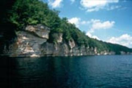
Superb water quality and sheer sandstone cliffs make Summersville Lake a popular destination for outdoor enthusiasts.
Recreation
The 2790-acre lake provides excellent boating, water skiing, swimming, and scuba diving. Anglers will find large and smallmouth bass, walleye, panfish, and catfish. Trout are stocked below the dam in spring and fall. Visitors also enjoy the great hiking, biking, hunting, geocaching, and picnicking opportunities on the lands surrounding the lake. For high adventure seekers, whitewater rafting is available year-round on the world class Gauley River. The Summersville Lake area also offers technical rock climbing.
Facilities
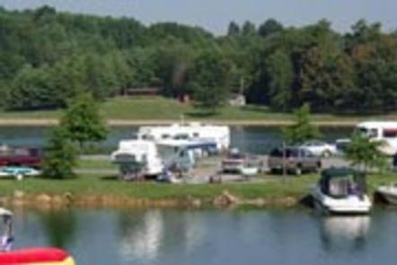
This large waterfront campground offers 110 campsites with electric hookups, along with seven primitive walk-to tent sites. Amenities include flush toilets, showers, drinking water, laundry facilities and a dump station. An accessible boat ramp and fishing dock are on-site. Younger campers love the park’s playground, nature trails, and large shade trees.
Natural Features
Scenic Summersville Lake is known for its striking cliffs and quiet coves along 60 beautiful miles of shoreline. Dense forests of maple, oak, hickory, beech and birch trees cover the region.
Wildlife, including black bear, deer, grouse and turkey, is abundant in the area.
Nearby Attractions
The historic Carnifex Ferry Battlefield State Park is a 10-minute drive from the campground. The park offers a museum, three Gauley River overlooks and hiking trails as well as a Civil War Battle Reenactment every other year. Summersville Lake Marina and Sarge’s Dive Shop are 11 miles away, offering kayak and pontoon boat rentals. The town of Summersville, another five miles north, has several grocery stores, restaurants and service stations. Mountain Lake Campground is a privately managed campground with lake access. Summersville Lake Retreat is three miles east on Route 129 offering cabins and lighthouse tours. World-renowned rock climbing on the New River Gorge- just 18 miles south. Within the 63,000 acres of New River Gorge River are over 1,400 established rock climbs. “The New” has become one of the most popular climbing areas in the country. The cliffs at New River Gorge are made up of a very hard sandstone, and range from 30 to 120 feet in height.