BLEDSOE FERRY, MO Campground Reservation, Info, Images, Map, Directions

BLEDSOE FERRY, Missouri Campground Images, Info & Reservations

Listen

Directions

From Highway 7, travel north on the Dam Access Road for 2 miles and follow signs to the day-use area.

Phone

660-438-7317

Activities

BIKING, BOATING, CAMPING, FISHING, HIKING, WILDLIFE VIEWING, MOUNTAIN BIKING, KAYAKING, CANOEING, BERRY PICKING, BIRDING, WATER ACCESS

Keywords

BLED,TRUMAN LAKE,BLEDSOE,HARRY S TRUMAN

Related Link(s)

Rec Area Info & Images

Missouri State Tourism

Missouri State Road Conditions

Overview

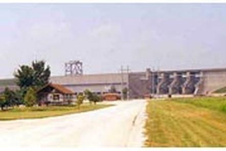
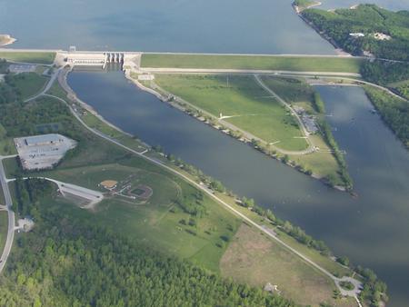
Bledsoe Ferry Park sits on the shores of Harry S. Truman Lake in the hills of western Missouri.

Visitors enjoy fishing, hunting, swimming and boating.

Click here for the Harry S. Truman Lake virtual tour.

Recreation

Bledsoe Ferry is an excellent fishing location. Anglers find crappie, largemouth bass and blue and flathead catfish. Truman Lake is also a popular destination for tournament fishermen.

The park also offers an excellent location to view "The Dam Experience," a huge annual fireworks display shot from the Truman Dam.

Facilities

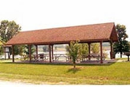
This year-round day-use area contains four group picnic shelters. Amenities include flush and pit toilets, drinking water, an accessible boat ramp and fishing dock.

Natural Features

Truman Lake lies among rolling hills and rocky bluffs. Dense hardwood forests studded with mature pine trees cover the area.

Nearby Attractions

The 950 miles of shoreline around Truman Lake provide plentiful opportunities for fun in the outdoors. Many parks surround the lake, including Harry S. Truman State Park.

The Harry S. Truman Visitor Center sits atop Kaysinger Bluff and provides a spectacular view of the dam and reservoir. Exhibits provide information about the rich history of the Osage River Valley from pre-civilization to modern day. Waterfowl, bald eagles and turkey vultures are commonly seen from the observation deck.

Reservation

More from CampingHiking.net:

BLACK CANYON CAMPGROUND, Oregon Campground Images, Info & Reservations

Listen Directions From Oakridge, Oregon, follow Highway 58 west about 8 miles to Black Canyon Campground, located 1 mile east of Lookout Point Reservoir. Phone 801-226-3564 Activities BIKING, BOATING, FISHING, KAYAKING Keywords BCAN,WILLAMETTE NF -FS Related Link(s) Rec Area Info & Images Oregon State Road Conditions Oregon State Tourism Forest

NORTH PINES, California Campground Images, Info & Reservations

Listen Directions Take Highway 41 north from Fresno, Highway 140 east from Merced, or Highway 120 east from Manteca into Yosemite National Park. Follow signs to Yosemite Valley and the campgrounds. Phone (209) 372-8502 Activities CAMPING Keywords Yosemite National Park,The Valley Related Link(s) Rec Area Info & Images California State

PEPPERSAUCE, Arizona Campground Images, Info & Reservations

Listen Directions From Tucson, drive north on Oracle Road (U.S. Highway 89). Continue for 27 miles to State Highway 77. Turn right (east) and drive 10 miles to the town of Oracle. Take the first Oracle exit and travel 4 miles through the town to Forest Road 38. Follow 38

MOUNTAIN PARK, Colorado Campground Images, Info & Reservations

Listen Directions From Fort Collins, travel west on Colorado Highway 14, to Ted’s Place, and continue up the Poudre Canyon to mile marker 98.8. Phone 970-295-6700 Activities BIKING, BOATING, CAMPING, FISHING, HIKING, WATER SPORTS, WILDLIFE VIEWING, BIRDING, RAFTING, WHITEWATER RAFTING Keywords MOUT,POUDRE RIVER,CACHE LA POUDRE RIVER,ARAPAHO AND ROOSEVELT NF –

YUBA PASS CAMPGROUND, California Campground Images, Info & Reservations

Listen Directions From Sierraville, travel south (west) on Highway 49 for 11 miles. Turn left at the entrance to the snow park and continue about a quarter-mile to the campground entrance on the right side of the road. Phone (530)478-6253 Activities BIKING, CAMPING, FISHING, HIKING, HUNTING, WILDLIFE VIEWING, STAR GAZING,

STONY FORK CAMPGROUND, Virginia Campground Images, Info & Reservations

Listen Directions From Wytheville, VA, follow I-77 north to Exit 47. Turn left onto Route 717 and drive 4 miles to Stony Fork Campground. Total travel distance is 10 miles. Phone 276-783-5196 Activities BIKING, CAMPING, FISHING, HUNTING, WILDLIFE VIEWING Keywords SFCA,GEORGE WASHINGTON/JEFFERSON NF-FS Related Link(s) Rec Area Info & Images