JACKSON FLATS, CA Campground Reservation, Info, Images, Map, Directions

JACKSON FLATS, California Campground Images, Info & Reservations

Directions

From Wrightwood, turn left onto CA-2 W/Angeles Crest Highway and go 6.1 miles. Look for signs and turn right. Drive 1.2 miles past Grassy Hollow Visitor Center and into the campground.

Phone

760-249-3526

Activities

CAMPING, HIKING, BIRDING

Keywords

JACK,ANGELES NF – FS,Jackson Flats

Related Link(s)

Rec Area Info & Images

California State Tourism

Forest Service Concessionaire

California State Road Conditions

Overview

Jackson Flats is a group camping facility located next to beautiful Grassy Hollow Visitor Center, which holds numerous nature programs, hikes and activities on Saturdays during the summer. The peaceful setting, in the Angeles National Forest, is a short drive northeast of the bustling Los Angeles metropolitan area.

Recreation

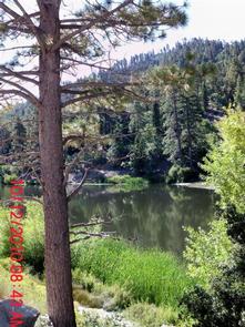
Campers can enjoy hiking, biking and relaxing in the shade. A few short trails loop around the campground and a connector trail leads to the Pacific Crest Trail. The trail stretches from Mexico through California, Oregon and Washington.

Additionally, the Angeles National Forest boasts 557 miles of hiking and equestrian trails. All trails, excluding the Pacific Crest Trail, allow mountain biking as well.

Facilities

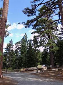
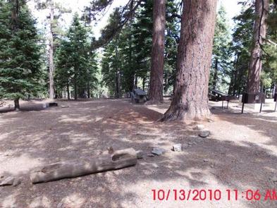
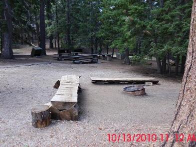
Each tent-only site is located about 600 feet from the centrally-located parking area near the campground entrance. Campers must park and carry their gear to their site.

Each site is equipped with large picnic tables, a campfire circle, grills and bear-proof food storage lockers. There is no water on site. Please bring all the water you will need for your stay.

Natural Features

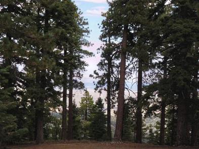
At an elevation 7,500 feet, Jackson Flats sits in grassy spaces among groves of pine and fir trees, with average summer daytime temperatures in the low 80s. Nights are cool.

In Angeles National Forest, vegetation ranges from chaparral and oak at lower elevations to pine forests at higher altitudes. Elevations range from 1,200 to 10,000 feet.

The endangered California condor inhabits the forest. The Least Bells vireo and the Southwestern Willow flycatcher are two migratory birds that visitors enjoy spotting in the area. Other local inhabitants include the Arroyo toad, mountain yellow-legged frog, the mountain lion and the two-striped garter snake.

Nearby Attractions

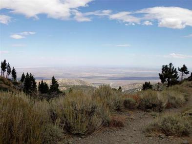
Hop in the car and drive along the Angeles Crest Highway, a scenic route that meanders through oak thickets, chaparral, high desert landscapes and pine forests.

Reservation

More from CampingHiking.net:

SPRING COVE, California Campground Images, Info & Reservations

Directions Spring Cove is located about 20 miles south of Yosemite National Park. From Highway 41, take Bass Lake turn-off (Road 222). Head southeast about 3.5 miles to the Bass Lake Campground registration office for check-in (keep to right). The campground is southeast another 4 miles. Phone 559-642-3212 Activities BOATING,

WEST SULLIVAN, Washington Campground Images, Info & Reservations

Directions Campground is located 90 miles from Spokane. , From the junction of Highway 20, take Highway 31 north towards Ione for 3 miles.. About 1 mile south of Ione, turn onto the Sullivan Lake Road (County Road 9345). Travel 12 miles to the north end of Sullivan Lake. Campground

PANTHER FLAT CAMPGROUND, California Campground Images, Info & Reservations

Directions From Highway 101 north of Crescent City, California, take highway 199 east for 16 miles to the campground. Phone 707-457-3131 Activities CAMPING, FISHING, SWIMMING SITE Keywords PANF,SIX RIVERS NF -FS Related Link(s) Rec Area Info & Images California State Tourism California State Road Conditions Overview Panther Flat Campground sits

NOISY CREEK, Washington Campground Images, Info & Reservations

Directions Campground is located ninety miles north of Spokane, Washington. From the junction of State Highway 20, take Highway 31 north for three miles to the junction of the Sullivan Lake Road (County Road 9345Follow the Sullivan Lake Road for 8 miles to the campground entrance. The campground is located

CHERRY GLEN CAMPGROUND, Iowa Campground Images, Info & Reservations

Directions From I-35, take exit 90 to Ankeny Industrial Parkway. Continue onto Highway 160 west for 4.8 miles. The road turns into Highway 415. Continue for another 4 miles and follow signs into the campground. Phone 515-964-8792 Activities BIKING, BOATING, CAMPING, INTERPRETIVE PROGRAMS, FISHING, HIKING, HUNTING, WATER SPORTS, WILDLIFE VIEWING,

ANCHOR PASS CABIN, Alaska Campground Images, Info & Reservations

Directions The cabin is approximately 50 air miles north of Ketchikan, located on the mainland shore of Anchor Pass across from the east end of Bell Island. It is accessible by floatplane or by boat. A mooring buoy is provided at the site on a first come-first serve basis. Refer