SUMMIT VIEW CAMPGROUND, UT Campground Reservation, Info, Images, Map, Directions

SUMMIT VIEW CAMPGROUND, Utah Campground Images, Info & Reservations

Listen

Directions

From Georgetown, Idaho, turn east on County Road 102. Travel two miles, and turn left on Forest Road 095 (the sign indicates the Left Fork of Georgetown Canyon). Continue about six miles, to the campground.

Phone

541-351-1182

Activities

BIKING, CAMPING, HIKING, HUNTING, WILDLIFE VIEWING, DAY USE AREA

Keywords

SUMM,CARIBOU-TARGHEE NF – FS

Related Link(s)

Rec Area Info & Images

Idaho State Road Conditions

Idaho State Tourism

Overview

Summit View Campground is located eight miles east of U.S. Highway 30, near Georgetown, Idaho. It is in a forested setting, high in the Bear River Range. Visitors enjoy exploring area trails, including the Great Western Trail, and picking seasonal wild huckleberries.

Recreation

Summit View sits within the Great Western Trail corridor, which offers excellent hiking, biking, horseback riding and off-road vehicle riding opportunities. The Harrington Peak trail, a 3.5-mile one-way trail to the summit, begins within the campground.

Facilities

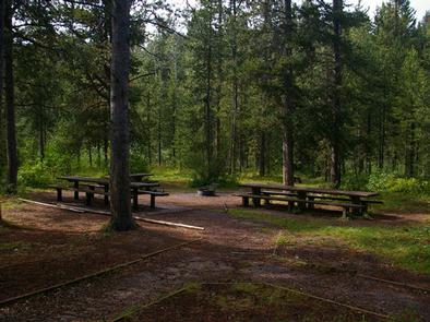
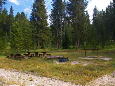
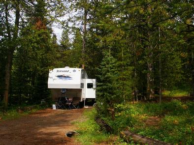
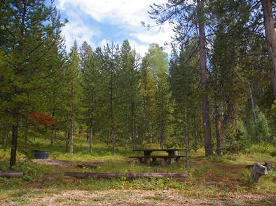
The campground contains 18 single-family campsites and three group sites. Vault toilets and drinking water are provided. An amphitheater is on-site. Roads and parking spurs within the campground are dirt.

Natural Features

The campground is situated in a lodgepole pine forest, where summer grasses and wildflowers are plentiful. During the fall, wild huckleberries can be found in abundance throughout the campground.

Reservation

More from CampingHiking.net:

SHAFER BUTTE, Idaho Campground Images, Info & Reservations

Listen Directions From Boise, Idaho, travel along Bogus Basin Road for approximately 20 miles. The last three miles are on a gravel road. Turn right (east) on the signed gravel road and travel just over a mile to the campground and picnic area. Phone 208-587-7961 Activities BIKING, CAMPING, HIKING, WILDLIFE

FISHING CREEK CAMPGROUND, Kentucky Campground Images, Info & Reservations

Listen Directions From Somerset, Kentucky, take Highway 80 west for 5 miles. Turn right on East Highway 1248 and continue for 2 miles. The recreation area entrance will be on the left side of the road at the bottom of the hill. Phone 606-679-5174 Activities BOATING, CAMPING, FISHING Keywords FISH,LAKE

WEST EAGLE CAMPGROUND, California Campground Images, Info & Reservations

Listen Directions From Susanville, California, take Highway 36 for 2 miles west to County Road A-1. Turn north and continue 14 miles to the Eagle Lake Recreation Area, following the signs to the campground. Phone 530-825-3212 Activities BOATING, CAMPING, HIKING, WINTER SPORTS, WATER SPORTS, WILDLIFE VIEWING, SWIMMING SITE Keywords WEEA,LASSEN

CARBOLYN PARK, Kansas Campground Images, Info & Reservations

Listen Directions Located 25 miles south of Topeka on US 75. The park entrance is 4.5 miles north of Lyndon, KS on US 75 on the east side of the road. Phone 785-453-2201 Activities CAMPING, PICNICKING Keywords CARB,LAKE POMONA,POMONA LAKE Related Link(s) Rec Area Info & Images Kansas State Road

GUT ISLAND 2 CABIN, Alaska Campground Images, Info & Reservations

Listen Directions The Gut Island Cabins are located on Gut Island, adjacent to the western tip of Farm Island on the Stikine River delta in the Stikine-LeConte Wilderness. The cabin is 12 miles by float plane or shallow draft boat from Wrangell, or 7 miles from the boat ramp on