
Directions
From Salida travel north on Highway 285 to the junction with Highways 24/285 near Johnson’s Village. Turn right onto Hwys 24/285, passing through Johnson’s Village. Stay on this highway for 5 miles, then watch for a sign on the left for County Road 307 (next to private property with railroad items on display). Turn right onto CR 307 and travel for 1.5 miles to the junction with CR 187. Turn right onto CR 187 and travel south for 7 miles to the intersection with CR 186. Turn left on CR 186 and travel southeast for .10 miles. Watch for a two-track road on the left(186 A). This road will take you to the gated entrance to the cabin. Roads may be slippery and muddy after rain or snow, drive with caution.
Phone
(719) 539-3591 (INFORMATION ONLY) CALL 1(877) 444-6777 FOR RESERVATIONS
Activities
BIKING, BOATING, CAMPING, FISHING, HORSEBACK RIDING, HUNTING
Keywords
BSMC,PIKE AND SAN ISABEL NF- FS
Related Link(s)
Colorado State Road Conditions
Overview
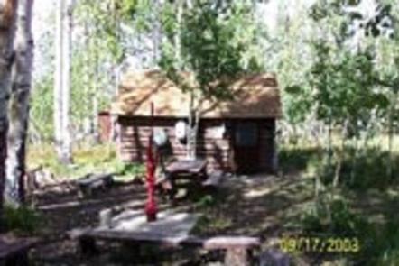
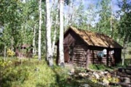
The cabin provides visitors with access to many recreation opportunities in the remote back country. The cabin was originally built around 1911 and was home to a forest guard. Early forest guards usually lived in tents, but if they were lucky, in a cabin like the Bassam Guard Station. Forest guards monitored grazing sheep and cattle, managed timber harvesting, apprehended poachers, and reported fire, road and weather conditions.
Recreation
Visitors may wish to take a day trip to the Arkansas River for kayaking, whitewater rafting or fishing. There are many recreational activities on the Salida Ranger District including hiking, biking, horseback riding, and OHV riding on designated forest roads and trails.
Or take a trip to the historic ghost town of St. Elmo. An old saloon, county courthouse and many other historic structures remain from the days of its mining glory.
The City of Salida and Town of Buena Vista offer visitors unique restaurants, shops, and art galleries to enjoy.
Facilities
The 14 x 16 cabin includes a full-sized bed, dresser, a small table with two chairs, a two-burner propane stove for cooking, and a wood-burning stove for heat. A metal campfire ring and picnic table are onsite. The cabin sleeps two adults, and an additional six adults may camp outside in tents or a camper. The bunkhouse and barn are off-limits to the public. Horses may be picketed or corralled outside of the fenced area by the entrance of the cabin site. Portable corrals are permitted, but must be moved every few days to prevent damage to vegetation and soil. Water is available at a hand pump, but guests are advised to bring extra drinking water. Limited cooking and dining utensils are provided. Guests should also bring food, matches, toilet paper, flashlights, bedding, garbage bags, and an ax for chopping firewood. Dead and downed wood may be collected and used in campfires and in the wood-burning stove.
Natural Features
The cabin sits in a stand of Aspens at an approximate elevation of 9,700 feet, south of Bassam Ridge. The cabin is within the Salida Ranger District, spanning 440,000 acres of public lands in central Colorado. The Arkansas River valley is known locally as the “Banana Belt of Colorado” because of the generally mild temperatures and sunny days. Springtime can be deceptive with sporadic spring snowstorms occurring from March to May. During the summer months, days are warm with cool nights. Afternoon thundershowers are common during July and August. The fall months are are generally dry and sunny with cooler morning temperatures.
Nearby Attractions
The cabin is located near the eastern boundary of Browns Canyon National Monument. Explore the monument from the Bassam Park area on foot or mountain bike (trail 1435). Or, for those with high clearance vehicles, take a scenic drive along Aspen Ridge Road (road 185). Note that much of the monument’s western side is being managed as a wilderness study area, so motorized vehicles and bicycles are not allowed.