LOST CABIN CAMPGROUND, WY Campground Reservation, Info, Images, Map, Directions

LOST CABIN CAMPGROUND, Wyoming Campground Images, Info & Reservations

Listen

Directions

From Buffalo, Wyoming, take U.S. Highway 16 southwest about 27 miles.

Phone

406-587-9054

Activities

BIKING, CAMPING, FISHING, HIKING, WILDLIFE VIEWING

Keywords

LCBN,BOULDER PARK,BIGHORN NF – FS

Related Link(s)

Rec Area Info & Images

Overview

Lost Cabin Campground is located 29 miles west of Buffalo, Wyoming on the east side of scenic Cloud Peak Skyway, near the Cloud Peak Wilderness Area. The Bighorn National Forest offers a wide variety of activities, including hiking, fishing, scenic driving and a number of historic sites. The administering organization is Gallatin Canyon Campgrounds; e-mail: gccampgrounds13@gmail.com

Recreation

Scenic off-road driving is available on nearby Elgin Park, Pole Creek and Crazy Woman Canyon Roads. Hiking and mountain biking are allowed on these roads as well.

Many additional hiking trails are available in the Cloud Peak Wilderness. A short trail leads from the campground to a scenic creek below.

Facilities

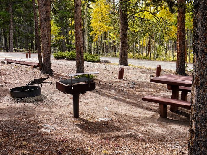
The campground offers several single-family sites each equipped with a picnic table and campfire ring with grill. Accessible vault toilets, drinking water and trash collection are provided.

The nearest dump station is 12 miles away on Powder River Pass.

Natural Features

The campground is situated on a hillside above Highway 16. A dense forest of lodgepole pine covers the area and North Fork Creek flows nearby.

Nearby Attractions

Meadowlark Lake is 20 minutes west of the campground, and Tie Hack Reservoir is 20 minutes north. Both lakes are great locations for canoeing and fishing.

The High Park Lookout is located just east of Meadowlark Lake. This old fire lookout was built by the CCC decades ago and is no longer active. A short hike leads to the lookout, where hikers are awarded panoramic views of the surrounding area.

South Fork Lodge is nearby, offering dining options, lodging, guided horseback riding and fishing and camping supplies.

Charges & Cancellations

Refunds: Refund requests made through www.recreation.gov will be charged a $10 processing fee. This cancellation processing fee is retained by the reservation service contractor along with the non-refundable reservation fee. All requests for the return of the non-refundable reservation fee and the cancellation processing fee will be declined by the campground concessionaire as they did not receive these fees (these are the fees retained by the reservation contractor, a different entity).

Reservation

More from CampingHiking.net:

BELKNAP, California Campground Images, Info & Reservations

Listen Directions From Springville, California, proceed east on State Highway 190 for approximately 15 miles. Turn east on Nelson Drive and continue about a mile to the campground. Phone 559-539-5230 Activities BIKING, CAMPING, FISHING, HIKING Keywords BELK,GIANT SEQUOIA NATIONAL MONUMEN,SEQUOIA NF – FS Related Link(s) Rec Area Info & Images

DEVILS ELBOW CABIN, Alaska Campground Images, Info & Reservations

Listen Directions Access is by boat (66 miles from Petersburg or 26 miles from Kake) or float plane (44 miles from Petersburg). A 16-foot tide is required for direct float plane access to the cabin. Arrival at lower tides will require a half-mile walk on the tide flat. Refer to

SOUTH FORK (WYOMING), Wyoming Campground Images, Info & Reservations

Listen Directions From Buffalo, Wyoming, take U.S. Highway 16 west for 15 miles to Forest Service Road 337. Follow Forest Service Road 337 east for .25 miles to the campground. Phone 406-587-9054 Activities BIKING, BOATING, CAMPING, FISHING, HIKING, HORSEBACK RIDING, HOTEL/LODGE/RESORT PRIVATELY OWNED, OFF ROAD VEHICLE TRAILS Keywords SOU1,SOUTH FORK

GRANT RIVER, Wisconsin Campground Images, Info & Reservations

Listen Directions From WI-133, Turn East on River Lane (two miles south of Potosi) and follow the directional signs approximately two miles to the campground. From US-61/WI-35, Turn S on River Lane and follow directional signs to campground. Phone RANGER OFFICE – 563-582-0881 / CAMPGROUND ENTRANCE STATION – 608-763-2140 Activities

BIG COON CREEK, Arkansas Campground Images, Info & Reservations

Listen Directions From Gillham on Hwy 71, go east on Tower Rd. for 1.3 miles; Turn left onto Gillham Lake Rd. for 4.3 miles; Turn left onto Polk Road 474 for 1.7 miles. Phone 870-385-7126 Activities BOATING, CAMPING, FISHING, HIKING, HUNTING, SWIMMING SITE Keywords BIGC,GILLHAM LAKE,GILLHAM LAKE Related Link(s) Rec Area

ALLRED FLATS GROUP PICNIC SITE, Wyoming Campground Images, Info & Reservations

Listen Directions From Afton, Wyoming, take Highway 89 south for approximately 21 miles over Salt Pass and look for a brown sign signaling the right-hand turn for Allred Flats Campground. The picnic area is on the left, just before the campground entrance kiosk. Phone 307-828-5100 Activities BIKING, CAMPING, FISHING, HIKING,