GREEN RIVER LAKES, WY Campground Reservation, Info, Images, Map, Directions

GREEN RIVER LAKES, Wyoming Campground Images, Info & Reservations

Listen

Directions

From Pinedale, drive 7 miles west on U.S. Highway 191. Turn north onto Wyoming Highway 352 and continue 25 miles to the forest boundary, where the pavement ends. Continue on the dirt road for 18 miles to the campground. While the dirt road to the campground is suitable for 2 wheel drive vehicles, weather can make this road impassable to all but 4 wheel drive vehicles, call the district office to inquire on road conditions.

Phone

1-307-367-4326

Activities

BIKING, BOATING, CAMPING, FISHING, HIKING, HORSEBACK RIDING, WILDLIFE VIEWING, SWIMMING SITE

Keywords

GRRI,BRIDGER-TETON NF – FS,Flaming Gorge National Recreation Area

Related Link(s)

Rec Area Info & Images

Overview

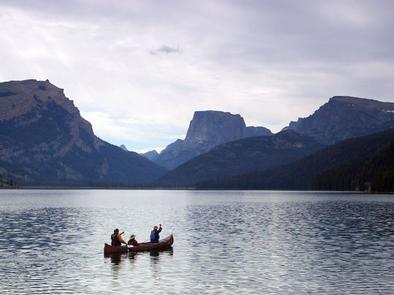
Green River Lakes Campground is located near the shores of beautiful Lower Green River Lake, at an elevation of 8,000 feet. The lake sits on the western edge of the rugged Wind River Range in Wyoming. Visitors enjoy hiking and backpacking into the adjacent Bridger Wilderness, as well as fishing and canoeing on the lake.

Recreation

The lake is open to small watercraft only, making it an excellent location for canoeing and kayaking. A primitive, carry-down boat launch is located at the lakeshore. Anglers fish for brook, cutthroat, rainbow and mackinaw trout. Hiking and horseback riding into the Bridger Wilderness and Wind River Range are popular activities enjoyed by visitors to the area. Trails in the area include the Continental Divide Trail, Highline Trail and Lakeside Trail. A trailhead parking area, horse corral and water trough are just outside the campground.

Facilities

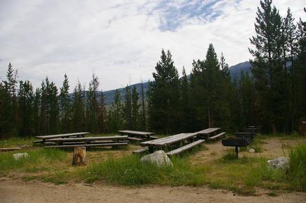
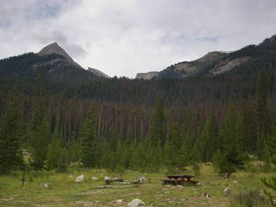
The campground contains three large-group campsites with picnic tables, food storage locker, campfire circles and grills. Sites A and B can accommodate up to 35 people each, and site C can accommodate up to 50 people. Vault toilets and drinking water are available. A campground host is located on-site. Roads and parking spurs within the campground are dirt. Parking for the group sites are not designed for large RVs or trailers.

36 additional single sites are available within the campground, they are first come/first served. No reservations.

Natural Features

Square Top Mountain towers over scenic Green River Lakes. This unique peak is part of the Wind River Range and tops out at an elevation of 11,581 feet. Most campsites afford scenic views of the peak and the lake below. Lodgepole pines dot the campground, offering very limited shade. Wildlife and summer wildflowers are abundant in the area.

Nearby Attractions

Pinedale is the nearest full service community, and is located 50 miles south of the campground.

Reservation

More from CampingHiking.net:

LAKE CAMPGROUND, California Campground Images, Info & Reservations

Listen Directions From Wrightwood, turn left on CA-2 W/Angeles Crest Highway and drive for 3.6 miles. Then turn right onto Big Pines Highway and drive 2.7 miles. Look for signs into the campground. Phone 760-249-3526 Activities CAMPING, HIKING Keywords LAKE,ANGELES NF – FS,LAKE,lake,california,Lake at Wrightwood,Lake at Big Pines,Jackson Lake Related

LONGWOOD PARK, Virginia Campground Images, Info & Reservations

Listen Directions The physical address for Longwood Park is: 13500 Hwy 15, Clarksville, VA 23927. It is located 7 miles south of Clarksville, VA. Phone 434-374-2711 IN SEASON ONLY; ALL OTHERS CALL 434-738-6143 Activities BOATING, CAMPING, FISHING, PICNICKING, WILDLIFE VIEWING, SWIMMING SITE, CANOEING Keywords LONG,BUGGS ISLAND,JOHN H KERR DAM Related

SYCAMORE CABIN, Arizona Campground Images, Info & Reservations

Listen Directions From Phoenix, take I-17 north about 80 miles to Exit 268, the Dugas/Orme Road exit. Go east toward Dugas. You will be on Forest Service Road 68. Travel east 8 miles continuing past Dugas for half a mile and then turn right (south) at the "Sycamore A.S." (Forest

SPANISH CREEK CAMPGROUND, California Campground Images, Info & Reservations

Listen Directions From Oroville, travel east on Highway 70 for 75 miles. The turnoff to the campground is two miles past Highway 89. From Quincy, travel west on Highway 70 for 8 miles. Campground is across the Spanish Creek bridge. Phone 530-283-0555 Activities CAMPING, FISHING, HIKING, WATER SPORTS, SWIMMING SITE

HENDERSON PARK, Arkansas Campground Images, Info & Reservations

Listen Directions From Mountain Home, Arkansas, travel east on US Highway 62/412 10 miles to the town of Henderson. Look for park signs for the park entrance on the left. Phone 870-425-2700 Activities BOATING, CAMPING, FISHING, HUNTING, WATER SPORTS, DAY USE AREA, HOTEL/LODGE/RESORT PRIVATELY OWNED Keywords Related Link(s) Rec Area

ASPEN GROUP (INYO), California Campground Images, Info & Reservations

Listen Directions From Bishop, California, take Highway 395 northwest for 25 miles. Turn south at Tom’s Place, and continue driving south for 4 miles onto Rock Creek Road, following signs to the campground. Phone 760-935-4321 Activities CAMPING Keywords ASPR,INYO NF – FS Related Link(s) Rec Area Info & Images Forest