SIBLEY LAKE, WY Campground Reservation, Info, Images, Map, Directions

SIBLEY LAKE, Wyoming Campground Images, Info & Reservations

Listen

Directions

From Dayton, Wyoming, take U.S. Highway 14 southwest about 25 miles to the campground.

Phone

406-587-9054

Activities

BIKING, BOATING, FISHING, HIKING, VISITOR CENTER, WILDLIFE VIEWING, CANOEING, BIRDING

Keywords

SIBL,BIGHORN NF – FS

Related Link(s)

Rec Area Info & Images

Overview

Sibley Lake Campground is located at Sibley Lake along the Bighorn Scenic Byway (U.S. Highway 14) near the Burgess Junction at an elevation of 7,900 feet. The Bighorn National Forest offers a wide variety of activities, including hiking, fishing, scenic driving and a number of historic sites. The administering organization is Gallatin Canyon Campgrounds; e-mail: gccampgrounds13@gmail.com

Recreation

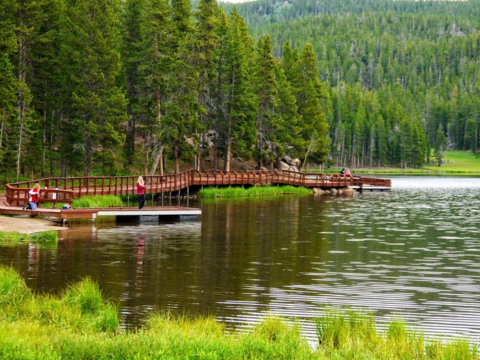
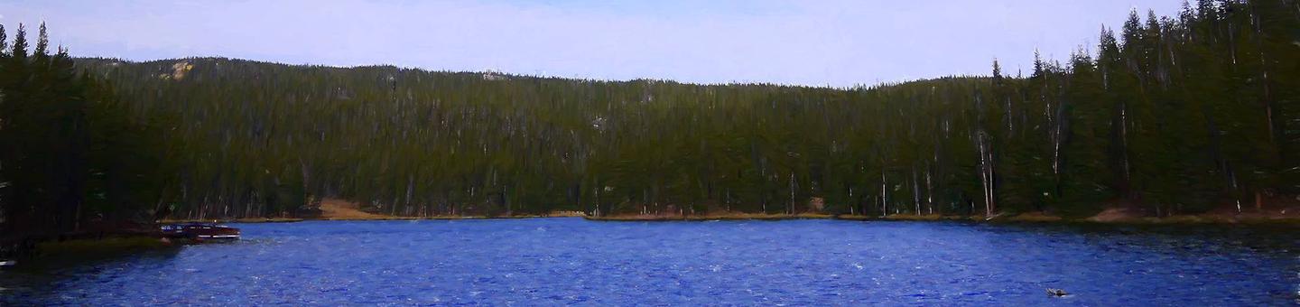
Sibley Lake is open to non-motorized craft and offers an accessible fishing dock on the shoreline. Anglers fish for rainbow, brown and brook trout.

Off-road vehicle trails, scenic jeep roads, hiking and additional fishing streams are available in the surrounding area. Diverse hikes vary from loop trails to treks along creeks and over mountain peaks; many trails access the Cloud Peak Wilderness.

Facilities

The campground offers several single-family sites each equipped with a picnic table and campfire ring with grill. Accessible vault toilets, drinking water and trash collection are provided.

Natural Features

The campground is situated near Sibley Lake and Prune Creek in the Bighorn Mountains, where craggy granite peaks rise over 13,000 feet above sea level. A forest of lodgepole pine covers the area, creating excellent wildlife habitat.

Nearby Attractions

Shell Falls Visitor Center, at the overlook of Shell Falls, is about 25 miles southwest. This center offers interpretive trails, scenic views, and educational displays about natural features such as flora and fauna and area history.

Charges & Cancellations

Refunds: Refund requests made through www.recreation.gov will be charged a $10 processing fee. This cancellation processing fee is retained by the reservation service contractor along with the non-refundable reservation fee. All requests for the return of the non-refundable reservation fee and the cancellation processing fee will be declined by the campground concessionaire as they did not receive these fees (these are the fees retained by the reservation contractor, a different entity).

Reservation

More from CampingHiking.net:

PORTAL BUNKHOUSE, Arizona Campground Images, Info & Reservations

Listen Directions From Tucson, take I-10 east for 139 miles to Road Forks, NM. Turn right (south) on US 80 and drive 28 miles to Portal Road. Turn right (west) and drive 7 miles through the town of Portal. Turn left on Forest Road 42 for approximately 1 mile. The

ALLRED FLATS GROUP PICNIC SITE, Wyoming Campground Images, Info & Reservations

Listen Directions From Afton, Wyoming, take Highway 89 south for approximately 21 miles over Salt Pass and look for a brown sign signaling the right-hand turn for Allred Flats Campground. The picnic area is on the left, just before the campground entrance kiosk. Phone 307-828-5100 Activities BIKING, CAMPING, FISHING, HIKING,

HIGH VIEW, Texas Campground Images, Info & Reservations

Listen Directions From Ennis, Texas: From Interstate 45, exit onto U.S. Highway 287 Bypass (Exit #247). Travel 4.5 miles and exit at the Bardwell Lake exit sign. Turn left onto Highway 34 and go 2.5 miles southwest. After crossing the Bardwell Lake bridge, take the first left onto High View

ACKER ROCK LOOKOUT, Oregon Campground Images, Info & Reservations

Listen Directions Important note regarding GPS use: please be advised that GPS units can, and have sent guests down the wrong roads to access the Lookout. Please consider following the directions below rather than your GPS unit. Directions: From Canyonville take West 1st Street and turn onto SE 3rd St/OR-227.

SIX MILE CREEK, Alabama Campground Images, Info & Reservations

Listen Directions From Selma, Alabama, follow US-41 south for 9 miles. Turn right on County Road 139 and follow the signs into the campground. Phone 334-872-9554 Activities BOATING, CAMPING, FISHING, HUNTING Keywords SIXM,ALABAMA RIVERS,ROBERT F. HENRY,MILLERS FERRY LAKE,WILLIAM DANNELLY,ALABAMA RIV. – DAN Related Link(s) Rec Area Info & Images Alabama

GILL POINT, South Carolina Campground Images, Info & Reservations

Listen Directions From Lincolnton, GA, travel approximately 12 miles north on SR-79. Phone 800-5333478 Activities BOATING, DAY USE AREA, SWIMMING SITE, ACCESSIBLE SWIMMING Keywords GILL,J STROM THURMOND LAKE Related Link(s) Rec Area Info & Images Georgia State Tourism Georgia State Road Conditions Overview Gill Point Recreation Area is a rural