
Directions
Located 32 miles east of Greybull, Wyoming, on U.S. Highway 14. Turn off onto Paintrock Lakes Road (Forest Road 17). Shell Creek Campground is 1.5 miles from the turnoff.
Phone
406-587-9054
Activities
BIKING, CAMPING, FISHING, HIKING, HORSEBACK RIDING, WILDLIFE VIEWING
Keywords
SHEL,BIGHORN NF – FS
Related Link(s)
Overview
Shell Creek Campground is located just off the Bighorn Scenic Byway (U.S. Highway 14) at an elevation of 7,500 feet. The Bighorn National Forest offers a wide variety of activities, including hiking, fishing, scenic driving and a number of historic sites. The administering organization is Gallatin Canyon Campgrounds; e-mail: gccampgrounds13@gmail.com
Recreation
Scenic off-road driving is available on Battle Creek Road to Medicine Lodge Lake, Ranger Creek Road to Shell Reservoir, Hunt Mountain Road and the Burgess Overlook jeep trail.
Diverse hiking opportunities vary from loop trails to treks along creeks and over mountain peaks including access to the Cloud Peak Wilderness. The Adelaide Trail, for hiking and horseback riding is nearby, providing access to Shell Creek and the Shell Creek Trail.
Many creeks, lakes and ponds dot the region, offering some of the best trout fly-fishing in the state.
Facilities
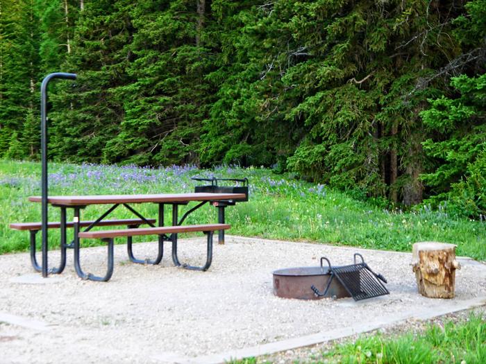
The campground offers single-family sites, most of which are accessible, each equipped with a picnic table and campfire ring with grill. Accessible vault toilets, drinking water and trash collection are provided.
The nearest dump station is 19 miles away at Burgess Junction.
Natural Features
The campground is situated on the banks of Shell Creek in the Bighorn Mountains, where craggy granite peaks rise over 13,000 feet above sea level. The area is forested with a mix of fir, aspen and cottonwood trees. An abundance of wildlife lives in the area.
Nearby Attractions
Shell Falls Visitor Center, at the overlook of Shell Falls, is about 6 miles west. This center offers interpretive trails, scenic views, and educational displays about natural features such as flora and fauna and area history.
Elk View Inn and other nearby lodges offer guided horseback riding and fishing adventures, off-road vehicle rentals and fishing supplies, as well as dining options, showers and general stores.
The Red Gulch Dinosaur Tracksite, near the town of Shell, is the largest of its kind in the state and one of only a few in the world from the Middle Jurassic Period. The tracks found here are approximately 167 million years old.
Charges & Cancellations
Refunds: Refund requests made through www.recreation.gov will be charged a $10 processing fee. This cancellation processing fee is retained by the reservation service contractor along with the non-refundable reservation fee. All requests for the return of the non-refundable reservation fee and the cancellation processing fee will be declined by the campground concessionaire as they did not receive these fees (these are the fees retained by the reservation contractor, a different entity).