


Directions
From Highway 50: Go approximately 32 miles east of Placerville or 25 miles west of South Lake Tahoe. Turn south on to Silver Fork Road 11N40. Travel approximately 2 miles on Silver Fork Road. Turn right into the China Flat Day Use parking area approximately 300′ feet past the China Flat Campground entrance. The Harvey West Cabin is located on the other side of the Silverfork American River. The combination for the bridge and the cabin will be given to you when you pick up your permit at the Placerville Ranger Station. The Placerville Ranger Station is on Highway 50 in Camino (8 miles east of Placerville). Take Exit 54 and go south on Eight Mile Road. The Ranger Station is the first driveway on your right.
Phone
530-644-2324
Activities
CAMPING, FISHING, HIKING, SWIMMING SITE
Keywords
HWCA,CHINA FLAT,SILVER FORK AREA,ELDORADO NF – FS
Related Link(s)
California State Road Conditions
Overview
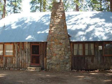
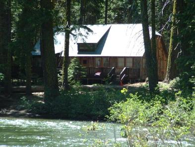
The Harvey West Cabin is located on the Silver Fork of the American River. The cabin is easily access from Silver Fork Road. The cabin has beds for 12 and can accommodate an additional eight on the floor or on the large front deck. Harvey West Cabin provides a cozy mountain cabin getaway experience while also providing a few modern conveniences. The Harvey West Cabin was constructed in the early 1930s by the Sacramento Box and Lumber Company. The building was used as an office and recreational facility until it was purchased in 1936 by Harvey West. West, a prominent local businessman and philanthropist, used the cabin as a summer retreat for his famiy until the early 1970s.
Recreation
Fishing for brown and rainbow trout is a popular activity on the river. Other pleasant pastimes include bird watching, hiking and wading in the river. The walking distance China Flat Day Use Area offers picnic tables and a beach on the riverbank.
Facilities
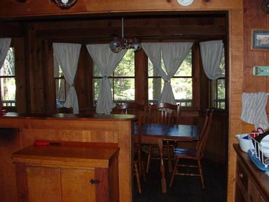
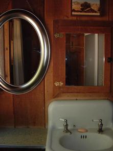
The 2,000 sq. ft.two level cabin has a large, open great room, kitchen, two downstairs bedrooms, one and a half bathrooms, and two large lofts that overlook the great room. The cabin has beds for 12 (one queen, two double, four sinlge, two cots) and can accommodate an additional 8 on the floor of the great room or on the large deck that overlooks the river. The cabin contains a dining table and chairs, two couches, and other assorted furniture. The cabin has two flush toilets and hot and cold running water in the kitchen, bathrooms, and shower. There is a limited assortment of pots, pans, dishes, utensils, cookware, and other kitchen items. The kitchen provides a propane stove/oven and propane refrigerator. No open flames, backpacking or Coleman type cooking stoves are permitted inside the cabin. The cabin does not have electricity. Propane lanterns are placed throughout the cabin but guests are encouraged to bring their own flashlights. The great room contains a propane heating stove and large stone fireplace. Firewood is not provided. Guests are required to bring their own food (in sealed containers) toilet paper, sunscreen, matches, clothing, towels, bedding, and any other items they will need for their stay. Limited cleaning supplies are provided. Guests are requred to bring their own trash bags and to remove all trash when they leave.
Natural Features
The cabin sits among Ponderosa pine and cedar trees along the Silver Fork of the South Fork American River, at an elevation of 4,720 feet. The region’s climate is similar to that of the Mediterranean with warm, dry summers and cold, wet winters.
Nearby Attractions
The town of Kyburz is 2 miles away and has limited services.