SUMMIT LAKE NORTH, CA Campground Reservation, Info, Images, Map, Directions

SUMMIT LAKE NORTH, California Campground Images, Info & Reservations

Listen

Directions

From Redding, California take State Highway 44 east approximately 48 miles to the Manzanita Lake entrance of the park. The campground is 14 miles south of the entrance on the main park road.

Phone

530 595-6121

Activities

CAMPING, FISHING, HIKING, PICNICKING, VISITOR CENTER, DAY USE AREA, SWIMMING SITE

Keywords

SULN,LASSEN VOLCANIC NATIONAL PARK

Related Link(s)

Rec Area Info & Images

California State Road Conditions

California State Tourism

Overview

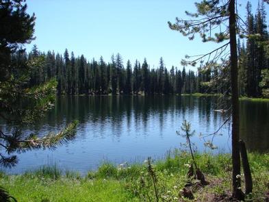
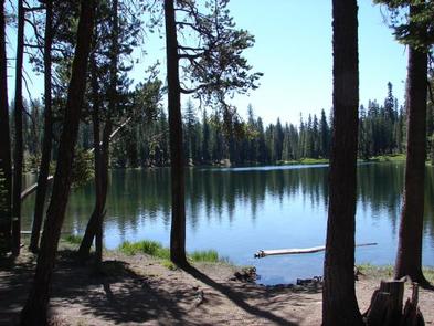
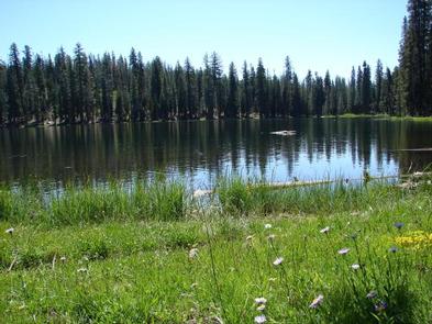
Summit Lake North Campground (elevation 6,700 ft.) is conveniently located on the main road of Lassen Volcanic National Park. The campground is within walking distance of the small but scenic Summit Lake and eight miles from the 10,457-ft. Lassen Peak, the largest volcano in the park..

Hikers will find one of the park’s major trails only 1/4-mile away from the campground and many more within a close proximity. Summit Lake North is on the opposite side of the lake from Summit Lake South Campground.

Recreation

The campground is a hub for hiking and backpacking enthusiasts. Campers can access many of the park’s 150 miles of hiking trails from the Summit Lake area. The Cluster Lakes loop trail–a major trailhead into the park’s interior that bypasses several alpine lakes and is popular among birders–is located a short walk from the Summit Lake Ranger Station. This is the closest campground to the Lassen Peak Trail and within 10 miles of the hydrothermal area Bumpass Hell. Educational programs are presented at an amphitheater within the facility.

Facilities

This facility has flush toilets, drinking water, campfire rings and picnic tables. For more information visit Campgrounds of Lassen Volcanic.

Natural Features

The national park is known for its volcanic history, as well as its diversity of plants and animals. It contains 300 active volcanic domes and many hydrothermal features, such as mud pots and steam vents. Lassen Peak is the southernmost active volcano in the Cascades, and the second most recent volcano to erupt in the lower 48 of the United States before Mount Saint Helens.

Lassen National Park boasts over 700 species of flowering plants and 250 native species including birds, mammals, reptiles and fish. The park is at the junction of the Cascade Mountains, the Sierra Nevada Mountains and the Great Basin, providing many unique habitats.

Reservation

More from CampingHiking.net:

Verlot Campground, Washington Campground Images, Info & Reservations

Listen Directions From Seattle, go north on I-5 to Everett. Take Exit 194 onto Highway 2. Head north at Highway 204 toward Lake Stevens. Turn north on Highway 9. Turn east on Highway 92 to Granite Falls, WA. Campground is 10.8 miles east of Granite Falls. Phone 360-804-1103 Activities CAMPING

NORTH FORK (ID), Idaho Campground Images, Info & Reservations

Listen Directions From Ketchum, Idaho, travel approximately 8 miles north on Highway 75. Campground is on the west side of the road. Phone 928-537-8888 Activities BIKING, CAMPING, FISHING, HIKING, WILDLIFE VIEWING Keywords NORF,SAWTOOTH NF – FS Related Link(s) Rec Area Info & Images Forest Service Concessionaire Idaho State Road Conditions

Panther Creek campground, Washington Campground Images, Info & Reservations

Listen Directions From Carson, WA: Travel 6 miles north to Old State Highway, (follow signs) turn right and then take your first left on Panther Creek Road. Proceed on Panther Creek Road for 4 miles to the campground. Phone 541-338-7869 Activities CAMPING, FISHING, HIKING, HUNTING Keywords PANC,GIFFORD PINCHOT NF –

HARDING RIVER CABIN, Alaska Campground Images, Info & Reservations

Listen Directions Located southeast of Wrangell on the mainland at the mouth of the Harding River, which is on the north side of the Bradfield Canal. Distance is 31 miles by air, 40 miles by boat from Wrangell. The beach near the cabin slopes gradually and does not provide for

ELK CREEK LANDING, Oklahoma Campground Images, Info & Reservations

Listen Directions From Tahlequah, OK, go 14 miles southeast on Highway 82, then turn right and go a mile on the paved access road. Phone 918-487-5252 Activities BOATING, CAMPING Keywords ELCL,TENKILLER LAKE,TENKILLER FERRY LAKE,TENKILLER FERRY Related Link(s) Rec Area Info & Images Oklahoma State Tourism Oklahoma State Road Conditions Overview

PLOWMAN CREEK, Texas Campground Images, Info & Reservations

Listen Directions From Kopperl, Texas, travel 1 mile south on FM 56. Follow signs into campground. Phone 254-622-3332 Activities BIKING, BOATING, CAMPING, FISHING, HIKING, HORSEBACK RIDING Keywords PLOW,WHITNEY LAKE,LAKE WHITNEY,WHITNEY LAKE Related Link(s) Rec Area Info & Images Texas State Road Conditions Texas State Tourism Overview PLOWMAN CREEK CAMPGROUND IS