IDLEWILD, OR Campground Reservation, Info, Images, Map, Directions

IDLEWILD, Oregon Campground Images, Info & Reservations

Listen

Directions

From Burns, OR: Travel northeast toward Vale 2.8 miles on US Highway 20 to the junction with US Highway 395, turn left onto US Highway 395 and head north. Follow US Highway 395 for approximately 14.6 miles to the junction with Forest Road 2820. Turn right and continue on Forest Road 2820 for 0.8 miles to the junction with Idlewild Campground Road. Turn right after the Sno-Park and follow Idlewild Road for approximately 1 mile to the campground.

Phone

541-573-4300

Activities

CAMPING, HIKING, MOUNTAIN BIKING, CROSS COUNTRY SKIING, SNOWMOBILE TRAILS

Keywords

IDLE,MALHEUR NF – FS

Related Link(s)

Rec Area Info & Images

Oregon State Tourism

Oregon State Road Conditions

Overview

Idlewild Campground is the perfect place for large gatherings in any weather. In sun, rain or snow, there are plenty of ways to enjoy the outdoors while spending time with friends and family.

The campground is situated along Highway 395 north of Burns, Oregon. In the summer, it is popular with hikers and mountain bikers. In the winter, visitors can snowmobile and cross-country ski.

Recreation

Idlewild offers opportunities for camping, picnicking, hiking and mountain biking. Devine Summit Trail begins within the campground. Snowmobiling and cross-country skiing bring visitors to the area in the winter.

Facilities

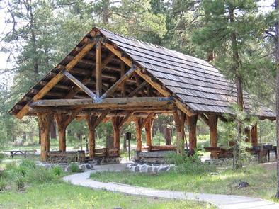
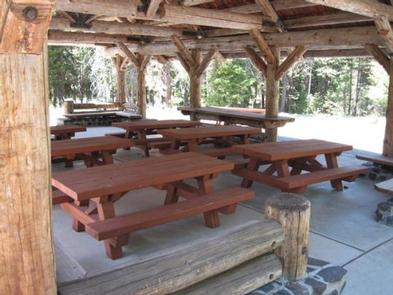
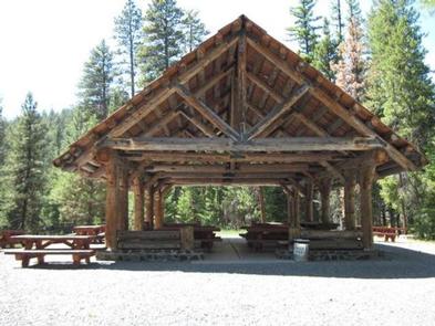
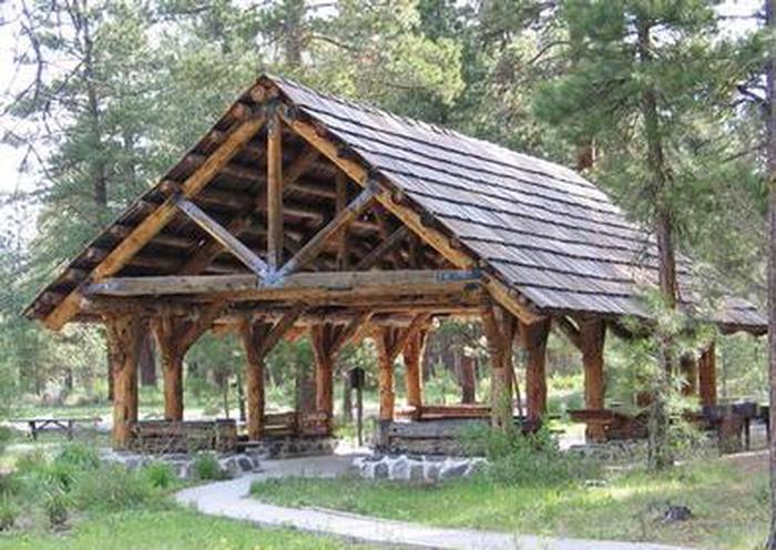
Idlewild contains one accessible, group day-use picnic shelter available for reservations for up to 75 people. It is equipped with picnic tables, a campfire ring and grills. Vault toilets and drinking water are provided. Individual sites for overnight camping are available on a first-come, first-served basis.

Natural Features

The campground is situated at an elevation of 5,000 feet in a large stand of Ponderosa pines. The group shelter sits near a meadow within Idlewild Campground. The Malheur National Forest encompasses 1.46 million acres in the Blue Mountains of eastern Oregon. The forest’s dramatic landscapes include the Strawberry Mountain Wilderness, with 9,038′ Strawberry Mountain, which extends east to west through the heart of the forest, and the Monument Rock Wilderness along the eastern boundary.

Nearby Attractions

The campground is located a short drive from Burns, Oregon. There are horse trails and equestrian camping within 10 miles of Idlewild.

Reservation

More from CampingHiking.net:

CAZIER CABIN, Wyoming Campground Images, Info & Reservations

Listen Directions From Afton, WY, take Highway 89 north about 31 miles to Alpine, WY. At Alpine, turn right (south) onto Greys River Road (Forest Road 10138) and travel about 46 miles. The cabin is located on the right (west) side of the road. Access is along a low-speed gravel

MURRAY BAY CAMPGROUND (MT), Montana Campground Images, Info & Reservations

Listen Directions From Martin City, Montana, turn off Highway 2 and continue on the main road through the town heading south. This road becomes East Side Reservoir Road. Continue for about 22 miles to the campground. Phone 406-752-7924 FOR RESERVATIONS CALL: 1-877-444-6777 Activities BOATING, CAMPING, FISHING, HIKING, WILDLIFE VIEWING, SWIMMING

WHITE CLIFFS PARK, Arkansas Campground Images, Info & Reservations

Listen Directions Located six miles south of Cowlingsville on State Highway 317. Phone 870-287-4253 Activities BOATING, CAMPING, FISHING Keywords Related Link(s) Rec Area Info & Images Arkansas State Tourism Arkansas State Road Conditions Overview White Cliffs Campground is located on the east bank of the Little River feeding into Millwood

TRAIL CREEK, Wyoming Campground Images, Info & Reservations

Listen Directions Located 7 miles southeast of Victor, Idaho, adjacent to Wyoming Highway 22, 2 miles south of Mike Harris Campground. Phone 208-270-0150 OR 541-351-1182 Activities BIKING, CAMPING, FISHING, HIKING, HUNTING Keywords TRCR,TRAIL CREEK CAMPGROUND,CARIBOU-TARGHEE NF – FS Related Link(s) Rec Area Info & Images Forest Service Concessionaire Overview Trail

TRAP CREEK CAMPGROUND, Idaho Campground Images, Info & Reservations

Listen Directions From Stanley, Idaho, take State Highway 21 west 12 miles. Take Forest Road 540 to Trap Creek Campground, located adjacent to State Highway 21. Phone 928-537-8888 Activities BIKING, CAMPING, FISHING, HIKING, WILDLIFE VIEWING Keywords TRAP,SAWTOOTH NF – FS Related Link(s) Rec Area Info & Images Idaho State Tourism