JUNCTION CREEK CAMPGROUND, CO Campground Reservation, Info, Images, Map, Directions

JUNCTION CREEK CAMPGROUND, Colorado Campground Images, Info & Reservations

Listen

Directions

From Main Street in Durango, travel west on 25th Street (across from the fairgrounds entrance) for just over three miles, to the forest boundary. Continue just over a mile to the campground entrance. The day-use area loops to the left.

Phone

661-702-1420

Activities

BIKING, BOATING, CAMPING, FISHING, HIKING, WILDLIFE VIEWING

Keywords

JUNC,SAN JUAN NF – FS

Related Link(s)

Rec Area Info & Images

Colorado State Road Conditions

Colorado State Tourism

Forest Service Concessionaire

Overview

Junction Creek Campground is located close to Durango, Colo., near the beginning of the Colorado Trail. Visitors enjoy the area for its excellent hiking and biking opportunities in a scenic natural setting.

Recreation

The Colorado Trail, also known as the Junction Creek Trail, begins nearby and stretches almost 500 miles to Denver as it rises through subalpine forests and alpine meadows above the timberline. Mountain biking is very popular on the Colorado Trail and the Logchute Trail System, which is nearby.

Junction Creek offers fishing for rainbow and brook trout. Skilled anglers may have luck near the campground, but chances improve upstream.

Facilities

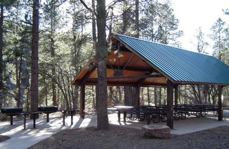
The campground offers single- and double-family campsites, many with electric hookups. A group campsite is available that can accommodate up to 50 people. An accessible large-group, day-use picnic shelter, with electricity, can accommodate up to 65 people.

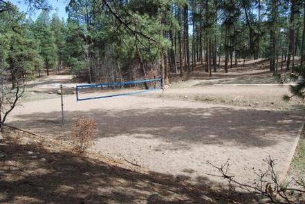
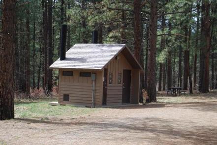
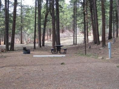
Group sites are equipped with picnic tables, serving tables, campfire rings and grills and have access to a volleyball court and horseshoe pits. Single and double sites have tables and campfire rings. Accessible vault toilets and drinking water are provided.

Natural Features

The campground is situated on a south-facing hillside, a quarter-mile above Junction Creek. A forest of ponderosa pine and gambel oak covers the campground, which sits at an elevation of 7,300 feet.

Nearby Attractions

Haviland Lake is a 35-minute drive from the campground. The 80-acre, no-wake lake offers boating, canoeing and fishing opportunities. Accessible fishing docks are located on the lakeshore.

The small town of Durango is just minutes away, offering whitewater rafting, a river trail, shops and restaurants. It is also home to the Durango & Silverton Narrow Gauge Railroad.

Reservation

More from CampingHiking.net:

MOSER ISLAND CABIN, Alaska Campground Images, Info & Reservations

Listen Directions Accessible year round, weather permitting. Located 48 air miles north of Sitka, within Hoonah Sound on the north end of Moser Island, north of Peril Strait. Access from Sitka is 30 minutes by floatplane, or 2 hours by boat. For geographic features surrounding the cabin, refer to USGS

Loft Mountain Campground, Virginia Campground Images, Info & Reservations

Listen Directions From Washington, D.C., metro area, travel west on Interstate 66 to exit 43A. Take US Highway 29 south approximately 55 miles to Ruckersville, Virginia, then take US Highway 33 west to Shenandoah National Park and Skyline Drive Swift Run Entrance. Follow Skyline Drive south approximately 15 miles and

MIDWAY, Texas Campground Images, Info & Reservations

Listen Directions From I-35, take the exit for Hwy 6 N toward Meridian (330B) for about 5 miles. Immediately before crossing the lake, exit right at Midway Park Exit. At the exit, drive under the bridge and the park is a quarter-mile down the east-bound service road. Phone 254-756-5359 Activities

SOUTH OVERLOOK (IA), Iowa Campground Images, Info & Reservations

Listen Directions 1105 North HWY T15 Knoxville, Iowa 50138 From Pella, Iowa, follow county road T-15 southwest for 4 miles, then follow signs to South Overlook. Phone 641-828-7522 Activities BIKING, BOATING, CAMPING, HUNTING, WILDLIFE VIEWING Keywords Related Link(s) Rec Area Info & Images Iowa State Road Conditions Iowa State Tourism

CRYSTAL SPRINGS, Arkansas Campground Images, Info & Reservations

Listen Directions From Hot Springs, Arkansas, take US 270 west about 15.4 miles to North Crystal Springs Road. Turn right and follow access road three miles north to the park. Phone 501-991-3390 Activities BOATING, CAMPING, SWIMMING SITE Keywords CRSP,LAKE OUACHITA,CRYSTAL,LAKE OUACHITA Related Link(s) Rec Area Info & Images Arkansas State

MINERS GULCH, Utah Campground Images, Info & Reservations

Listen Directions From Duchesne, Utah: Take Highway 87 north for 15 miles to the Mountain Home turnoff. Turn left and continue 2.5 miles north to the Rock Creek Store. Turn left toward Rock Creek Canyon and proceed approximately 15 miles to the campground. You’ll see a sign for Miners Gulch