JENNINGS FERRY, AL Campground Reservation, Info, Images, Map, Directions

JENNINGS FERRY, Alabama Campground Images, Info & Reservations

Listen

Directions

From Demopolis, Alabama, take Highway 43 north towards Eutaw. At Highway 14, take a right. Proceed for approximately seven miles to the park.

Phone

205-372-1217

Activities

CAMPING, FISHING, HIKING

Keywords

JENF,BLACK WARRIOR

Related Link(s)

Rec Area Info & Images

Alabama State Tourism

Alabama State Road Conditions

Overview

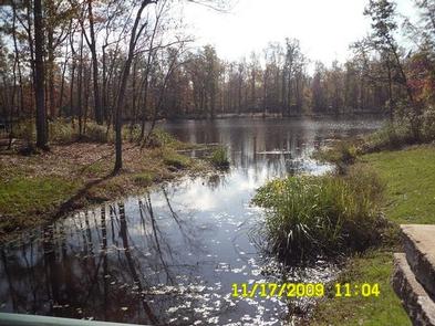
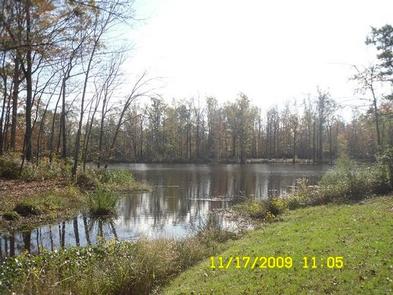
Jennings Ferry Campground is situated between the Black Warrior River and Clear Creek on the Black Warrior-Tombigbee Waterway in Alabama. With a boat ramp and gently sloping shoreline, this facility offers a quiet and convenient getaway for fishing.

Recreation

Fishing is the most popular activity on the waterway. Whether fishing by boat or along the shore of the park, anglers can fish for bass, crappie, bream, catfish and other species.

Visitors can also enjoy walking along a half-mile nature trail that runs through the woods following the water’s edge.

Facilities

Jennings Ferry has 52 campsites with 50-amp electrical and water hookups and picnic areas.

Campsites are spacious, private and located near or close to the water. A shower and restroom building, as well as coin-operated laundry facilities, a playground and boat ramp with security lighting are also provided for camper convenience.

Natural Features

The campground is surrounded by the scenic woodlands of the Tombigbee River. Deer, squirrel, wild turkey, migratory birds and blue birds live among the calm waters and hardwood forests of the area.

Temerature range from the 80s to 90s from April to September, and annual rainfall averages about 60 inches. The facility is located 100 feet above sea level.

Reservation

More from CampingHiking.net:

BLEDSOE FERRY, Missouri Campground Images, Info & Reservations

Listen Directions From Highway 7, travel north on the Dam Access Road for 2 miles and follow signs to the day-use area. Phone 660-438-7317 Activities BIKING, BOATING, CAMPING, FISHING, HIKING, WILDLIFE VIEWING, MOUNTAIN BIKING, KAYAKING, CANOEING, BERRY PICKING, BIRDING, WATER ACCESS Keywords BLED,TRUMAN LAKE,BLEDSOE,HARRY S TRUMAN Related Link(s) Rec Area

DONLEY CABIN, Tennessee Campground Images, Info & Reservations

Listen Directions From Tellico Plains, Tenn., travel east on Highway 165 (Cherohala Skyway) for 5 miles. Turn right onto Forest Road 210 and continue 9 miles to the intersection of Forest Road 217 (North River Road). There will be a sign for the Donley Cabin and North River Campground. Turn

GROUSE CREEK GROUP SITE, Washington Campground Images, Info & Reservations

Listen Directions Grouse Creek Campground is located approximately 7 miles up the Forest Service Road 6200/Chiwawa River Road. There is a gated spur road just off the main paved road on the left. The campground is at the end of the road alongside Grouse Creek. Phone 509-763-0700 Activities BIKING, CAMPING,

UPPER TWILIGHT GROUP SITE, Arizona Campground Images, Info & Reservations

Listen Directions From Safford, Arizona: Take State Route 191 south for 6 miles. Turn right onto State Route 366/Swift Trail and travel 14.5 miles to the Twilight Campground entrance (MM 128.4), following the road for 1 mile to the Upper Twilight Group Site.  From Tucson, Arizona: Take I-10 East for

CAMP HALE EAST FORK GROUP, Colorado Campground Images, Info & Reservations

Listen Directions From I-70, take exit 171 toward Minturn. Turn south on Highway 24 and continue for approximately 19 miles, just beyond Camp Hale Memorial Site. Turn onto Old Highway East and follow for 2 miles to the campground. Phone 970-468-7681 Activities CAMPING, FISHING, HIKING, WILDLIFE VIEWING Keywords EAF1,WHITE RIVER