PATTEE CANYON PICNIC AREA, MT Campground Reservation, Info, Images, Map, Directions

PATTEE CANYON PICNIC AREA, Montana Campground Images, Info & Reservations

Listen

Directions

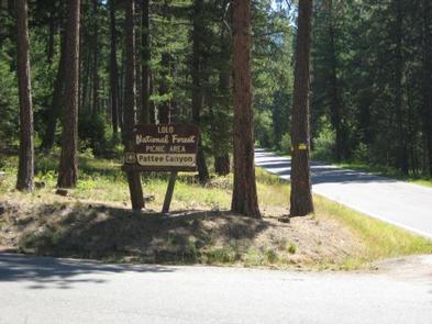
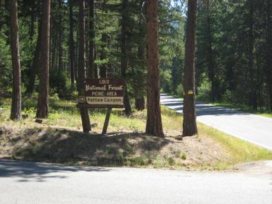
From I-90 in Missoula, take the Orange Street exit #104 and travel south. Turn left onto West Front Street and go 0.2 miles to South Higgins Avenue, then turn right. Continue on South Higgins Avenue for about 2.7 miles to Pattee Canyon Road, then turn left. On Pattee Canyon Road, travel 4 miles heading (east) up the canyon. Look for the Pattee Canyon Picnic Area sign and entrance.

Phone

406-329-3814

Activities

BIKING, CAMPING, HIKING, WINTER SPORTS, WILDLIFE VIEWING

Keywords

PATC,LOLO NF – FS

Related Link(s)

Rec Area Info & Images

Montana State Tourism

Montana State Road Conditions

Overview

The Pattee Canyon Picnic Area offers family picnic sites available for free, along with three group picnic sites available by reservation. The picnic area is open July 1 through Labor Day.

Recreation

The Pattee Canyon Recreation Area is a popular spot for day hikes, mountain biking, horseback riding and picnicking. There are several trailheads in the area. Cross-country skiing is popular in the area during winter months.

Facilities

The picnic area offers several individual- and group-sized picnic sites. The roads are paved and the group sites have trash collection receptacles and accessible vault toilets. Drinking water is not available at the picnic area. A host may be on-site during summer months.

Natural Features

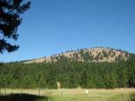
Set in a wooded canyon east of Missoula, at 4,100 feet, the picnic site is pleasantly shaded by large ponderosa pine trees.

Nearby Attractions

Pattee Canyon Picnic Area is located four miles southeast of Missoula.

Reservation

More from CampingHiking.net:

DOG CREEK (KY), Kentucky Campground Images, Info & Reservations

Listen Directions From Louisville, take I-65 south to exit 76 and turn west onto Highway 224. Continue for 9 miles, then turn left onto Highway 479. After 8 miles make another left onto Highway 88 and continue for about 2 miles to Highway 1015. Turn right and follow signs to

THREE LAKES, Michigan Campground Images, Info & Reservations

Listen Directions From Strongs Corner, turn south on Forest Road 3142 and travel approximately two miles. The campground is on the east side of the road. Phone (906) 643-7900 Activities BOATING, CAMPING, FISHING, HIKING, SWIMMING SITE Keywords THRE,Three Lake Campground,Softball Campground,HIAWATHA NF – FS Related Link(s) Rec Area Info &

ELK CREEK CAMPGROUND, Colorado Campground Images, Info & Reservations

Listen Directions Elk Creek is located off of US Hwy 50 between Gunnison and Montrose, along Blue Mesa reservoir. Phone 970-641-2337 Activities BIKING, BOATING, CAMPING, INTERPRETIVE PROGRAMS, FISHING, HIKING, HUNTING, VISITOR CENTER, WATER SPORTS, WILDLIFE VIEWING, DAY USE AREA, SWIMMING SITE Keywords ELKC,CURECANTI NATIONAL RECREATION,ELK CREEK CURECANTI NRA,CURECANTI Related Link(s)

Twelvemile Beach Campground, Michigan Campground Images, Info & Reservations

Listen Directions Phone 906-387-3700 Activities CAMPING, HIKING, BEACHCOMBING, BACKPACKING, ACCESSIBLE SWIMMING Keywords Related Link(s) Rec Area Info & Images Overview Twelvemile Beach Campground is a beautiful campground along Lake Superior located within the Pictured Rocks National Lakeshore, just 15 miles west of Grand Marais. There are 36 sites total, including

LOST CLAIM, California Campground Images, Info & Reservations

Listen Directions From Groveland, Take State Highway 120 east for 12 miles. The campground is just east of the Groveland Ranger District Office. Phone 209-379-2258 Activities BIKING, CAMPING, FISHING, HIKING, WILDLIFE VIEWING, STAR GAZING Keywords LOST CLAIM Related Link(s) Rec Area Info & Images California State Road Conditions Forest Service