DEER CREEK CABIN (WY), WY Campground Reservation, Info, Images, Map, Directions

DEER CREEK CABIN (WY), Wyoming Campground Images, Info & Reservations

Listen

Directions

From Afton, WY, take Highway 89 north about 31 miles to Alpine, Wyoming. At Alpine, turn right (south) onto Greys River Road (Forest Road 10138) and travel about 13 miles. The cabin is located on the left (east) side of the road, just past Murphy Creek Campground.

Access is along a low-speed gravel road.

Phone

307-886-5300

Activities

BIKING, BOATING, HISTORIC & CULTURAL SITE, CAMPING, FISHING, HIKING, HORSEBACK RIDING, HUNTING, WILDLIFE VIEWING

Keywords

DRCC,DEER CREEK CABIN,DEERCREEK CABIN,DEER CREEK,BRIDGER-TETON NF – FS

Related Link(s)

Rec Area Info & Images

Overview

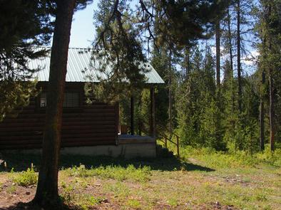
Deer Creek Cabin is a historic Forest Service guard station located 13 miles from Alpine, Wyoming. The quaint, rustic structure offers a backcountry experience with conveniences like a propane stove and a heater. The cabin compound is a free graze area for Forest Service horses to roam during the summer months.

Winter access is by snowmobile only on a groomed trail.

Recreation

Greys River flows just across the road from the cabin, offering prime fishing opportunities. Hiking, biking, horseback riding and off-road vehicle trails begin nearby.

Facilities

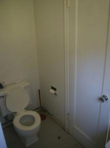
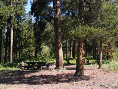
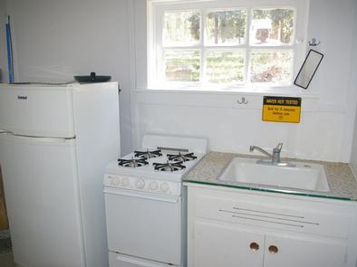
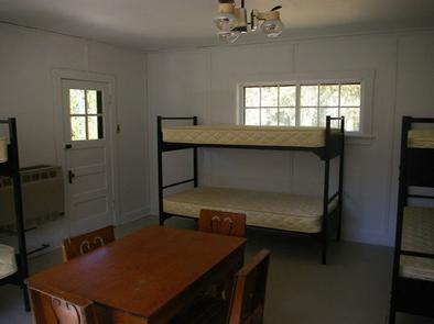
The two-room cabin sleeps six guests. Propane heating and lights are provided. Indoor plumbing is available during the summer months only, from around mid-June through Labor Day weekend. A vault toilet is available next to the cabin for colder months. A picnic table and campfire ring sit next to the cabin. A flush toilet, shower, and sink with drinking water are offered inside the cabin from approximately mid-June to Labor Day. Furnishings include a sink, propane cooktop, propane refrigerator, a table and chairs and three bunkbeds with mattresses. A wood stove and a propane heater are both available. Cooking and eating utensils are not provided. Recommended items to bring include bedding, dishes, pots and pans, utensils, garbage bags, dish soap, dish towels, toilet paper, a flashlight and cleaning products such as bleach or disinfectant.

Natural Features

Lodgepole pine trees cover the complex, offering partial shade. Scenic views of the Bridger-Teton National Forest abound.

Nearby Attractions

The closest town for groceries is in Alpine, just 13 miles away.

Reservation

More from CampingHiking.net:

WILLOW GROVE CAMPGROUND, Tennessee Campground Images, Info & Reservations

Listen Directions From Byrdstown, Tennessee, take Highway 111 south for about 13 miles. Turn north on 294/Willow Grove Road (at Big Springs Market) and continue for about 16 miles, then turn right into the camp entrance, just before Willow Grove Marina. It is recommended that visitors do not rely soley

Big Bend Group Sites, Utah Campground Images, Info & Reservations

Listen Directions From Moab, drive north to the junction with Highway 128. Turn right and travel 8 miles along the river road. Group sites A and B are in the main campground, site C is up the dirt road directly across from the main campground. Phone 435-259-2100 Activities AUTO TOURING,

CASCADE (COLORADO), Colorado Campground Images, Info & Reservations

Listen Directions From Buena Vista, Colorado, take Highway 285 south to Nathrop. Turn west on County Road 162 and travel 9 miles to the campground. Phone CAMPGROUNDS DO NOT HAVE PHONE SERVICE, CALLING TO CHECK AVAILABILITY PRIOR TO ARRIVAL IS NOT POSSIBLE. FOR RESERVATIONS CALL: 1-877-444-6777 Activities HISTORIC & CULTURAL

PAINT CREEK DAM SITE, Ohio Campground Images, Info & Reservations

Listen Directions From Chillicothe Ohio, take Route 50 west for 18 miles to Bainbridge. Ohio. Three miles past Bainbridge, turn right on Rapid Forge Road. Go 2 miles north and turn left into the Paint Creek Dam Site Area. Little Pond Shelter is located on the right just before crossing

DRY GULCH, California Campground Images, Info & Reservations

Listen Directions From Highway 140, turn on to Foresta Road. Landmarks include Red Bud Picnic Area and a National Park Service warehouse. After bridge, turn left onto the spur road. Immediately turn left onto Incline Road. Continue 1.3 miles to the facility. Phone 559-642-3212 Activities CAMPING Keywords DRYG,EL PORTAL,MERCED RIVER,SIERRA

EAST FORK (TX), Texas Campground Images, Info & Reservations

Listen Directions From Wylie, TX, take State Highway 78 North to Eubanks Lane. Turn left onto Eubanks, stay to the right at the fork in the road (onto Forrest Ross Road) and continue to the stop sign at the intersection of Forrest Ross Road and Skyview Drive. Continue straight into