


Directions
The cabin is accessible year-round by vehicle. From the 4-way stop light in Townsend, turn east on Hwy 12. Follow the road for 14 miles and watch for the Rillway Cabin sign along the right side of the highway at the 14-mile marker. There is also a sign that welcomes you to the National Forest.
Please note, only right turns are allowed when you leave the cabin area. Approximately 1 mile to the east is a pull out; use this to turn around if you must drive west. Please respect the private lands that are near the cabin site.
Phone
406-266-3425
Activities
BIKING, CAMPING, FISHING, HIKING, HUNTING, WINTER SPORTS, WILDLIFE VIEWING
Keywords
RWAY,DEER CREEK CABIN,SCOFFIELD CABIN,HELENA NF – FS
Related Link(s)
Overview
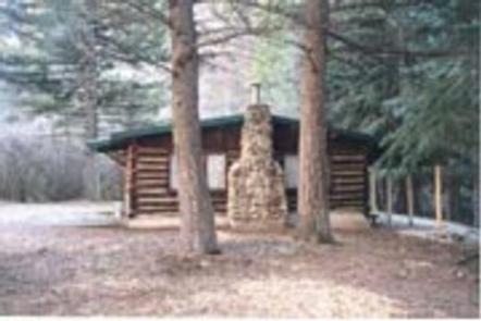
Rillway Cabin is located 14 miles east of Townsend, Montana along scenic Deep Creek in Helena National Forest. Its history can be traced to Dr. A.C. Kelly, a physician who arrived in Townsend in 1915 and served as mayor from 1920-1924. In 1918, Dr. Kelly obtained a term permit from the Forest Service for the cabin site. The cabin was built between 1918 and 1922, then sold to Nellie Hale Averill and her son-in-law, Floyd L. Hollaway. By 1924, the cabin was known as “Rillway,” a combination of the Averill and Hollaway family names. Today the cabin is a comfortable, rustic getaway for guests seeking relaxation and recreation in west-central Montana. It offers the easiest access of any cabins on the Helena National Forest, being accessible by vehicle year-round. Several amenities are offered, but guests will need to bring some of their own supplies.
Recreation
The cabin offers nearby access to a number of trails and roads. A cross-country ski trail is just up the highway and snowmobiling areas are close by as well. Deep Creek flows adjacent to the cabin, providing anglers with a scenic backdrop for fishing. The creek provides habitat for a variety of trout.
Facilities
The cabin can accommodate up to 6 people and comes furnished with 3 sets of bunkbeds with mattresses. Amenities include a fireplace insert, propane lanterns, a table and chairs, propane cook stove, cleaning supplies, utensils and cookware. An outhouse with vault toilet is near the cabin. An axe and snow shovel are provided. Firewood may be available, but it is not guaranteed. The cabin does not have electricity, running water or indoor plumbing. Guests must bring a sufficient amount of water for drinking, cooking and washing during their stay. Fuel is not provided for the lanterns or propane stove, so guests should bring 1 or 2 small propane cylinders, along with backup lighting. Guests need to provide their own sleeping bags, linens, towels, dish soap, matches, first aid kit, toilet paper and garbage bags. All trash and food should be packed out, and guests are expected to clean the cabin before leaving. No firewood provided from June 1st – August 31.
Natural Features
The cabin is tucked back near a moss-covered canyon wall with Deep Creek splashing through the backyard. The area around the cabin offers a variety of landscapes, from river banks to subalpine terrain. Valley bottoms, dense forests, meadows and barren ridges are mixed with streams, rivers and lakes. Wildlife in the area abounds, including the more common elk, mule and white- tailed deer, squirrel, black bear, moose and a variety of birds. The more elusive badger, wolverine, mountain lion and lynx find habitat here as well.