BIG BEND GROUP (YUBA RIVER), CA Campground Reservation, Info, Images, Map, Directions

BIG BEND GROUP (YUBA RIVER), California Campground Images, Info & Reservations

Listen

Directions

Physical Address:

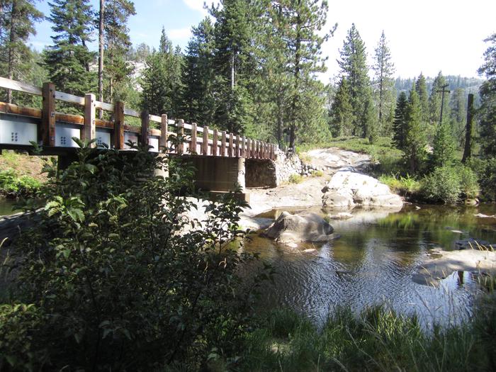
From Truckee, take I-80 19 miles west to the Rainbow Road Exit. Travel west about 1.5 miles to the Big Bend Ranger Station and Visitor Center. Turn right past the Visitor Center and cross bridge. The campground is on the right. Victory is the first campsite and Lincoln is the second one at the end.

Mailing Address & Phone Number displayed at the bottom on Recreation.gov is for mailing purpose, not campground.

Phone

530-478-6253

Activities

BIKING, CLIMBING, HISTORIC & CULTURAL SITE, CAMPING, FISHING, HIKING, DAY USE AREA, INFORMATION SITE, PHOTOGRAPHY, SWIMMING, MOUNTAIN BIKING, STAR GAZING, BIRDING, WATER ACCESS, GOLD PANNING, OFF HIGHWAY VEHICLE TRAILS

Keywords

BIBG,TAHOE NF – FS

Related Link(s)

Rec Area Info & Images

California State Tourism

California State Road Conditions

Overview

Big Bend Group Campground is located 19 miles west of Truckee, California in the Tahoe National Forest at an elevation of 5,700 feet. Visitors enjoy the area for its fishing and hiking opportunities, as well as its historic significance along the California Emigrant Trail.  This campground is operated and maintained by Forest Service staff.

Recreation

The South Yuba River offers swimming and rainbow trout fishing. The historic California Emigrant Trail and Loch Leven Trail are located nearby. The surrounding area offers many additional hiking, biking and off-road vehicle trails.

Facilities

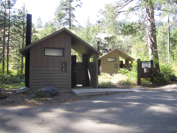
The campground offers two accessible group sites, Lincoln and Victory, which can accommodate up to 25 people and five vehicles each. Picnic tables, grills and large campfire rings are provided, as well as vault toilets and drinking water.

Natural Features

The campground lies along the gentle South Yuba River; just behind and across the river from the Big Bend Fire Station. Stands of pine and fir covers the area, offering pleasant shade at the group sites.

Nearby Attractions

Donner Lake is located 15 miles east via historic Route 40/Lincoln Highway, the nation’s first transcontinental highway. Many points of interest lie along Route 40, including China Wall, Rainbow Bridge, Sugar Bowl, Lake Van Norden and Ice Lakes.

Reservation

More from CampingHiking.net:

KALALOCH, Washington Campground Images, Info & Reservations

Listen Directions Kalaloch Campground is on Highway 101, 34 miles south of Forks, Washington, and 73 miles north of Aberdeen, Washington. Phone 360-565-3130 Activities CAMPING, HIKING, VISITOR CENTER, WILDLIFE VIEWING Keywords Clay-lock,Clay Lock,Olympic National Park Related Link(s) Rec Area Info & Images Washington State Tourism Washington State Road Conditions Overview

QUINN MEADOW HORSE CAMP, Oregon Campground Images, Info & Reservations

Listen Directions From Bend, travel southwest on Cascade Lakes Scenic Byway for 31.2 miles to the campground entrance. Phone 541-323-1746 Activities BIKING, CAMPING, FISHING, HIKING, HORSEBACK RIDING, DAY USE AREA Keywords QUIN,DESCHUTES NF – FS Related Link(s) Rec Area Info & Images Oregon State Road Conditions Oregon State Tourism Forest

SPRING, Oregon Campground Images, Info & Reservations

Listen Directions From Crescent, Oregon, travel 12.2 miles west on Road 61, then 3.5 miles north on Highway 58, then 8.1 miles west on Road 60 to the campground. Phone 541-323-1746 Activities BIKING, BOATING, CAMPING, FISHING, HIKING, VISITOR CENTER, WATER SPORTS, SWIMMING SITE Keywords None Related Link(s) Rec Area Info

WINDOW ROCK CABIN, Montana Campground Images, Info & Reservations

Listen Directions From Bozeman, MT: Drive south on S. 19th Ave. for about 7 miles. Turn left onto Hyalite Canyon Road FS 62. Drive about 12.7 miles to the Window Rock Cabin access road and gate on the right (west) side of the road. Use the cabin combination to unlock

POCKET PICNIC SHELTER, Georgia Campground Images, Info & Reservations

Listen Directions From I-75, take Exit 320 (LaFayette/Resaca) and head west on Georgia State Route 136 for approximately 14 miles. Turn left onto Pocket Road and continue approximately 7 miles. The recreation area is on the left. The second driveway leads to the picnic shelter. Phone 706-695-6736 Activities HISTORIC &

MUDDY GUARD CABIN, Wyoming Campground Images, Info & Reservations

Listen Directions From Buffalo, Wyoming, take Wyoming State Highway 16 west 24 miles. Turn left on Crazy Woman Road (FSR 33), travel 400 feet, turn right on Forest Service Road 473. Visitors will use a gate to access the cabin. Please keep the gate closed. Phone 307-684-7806 Activities BIKING, BOATING,