
Directions
From Buena Vista, Colorado, go about 15 miles north on Highway 24 towards Leadville. Turn left on County Road 390 at Clear Creek Reservoir. Go about 6 miles west on County Road 390, then turn right (north) onto the cabin driveway. The cabin is about 100 yards from the County Road. From Leadville, Colorado, go about 18 miles south on Highway 24 towards Buena Vista. Turn right on County Road 390 toward Clear Creek Reservoir. Go about 6 miles west on County Rpad 390, then turn right (north) onto the cabin driveway. The cabin is about 100 yards from the road.
Phone
719-486-0749 (INFORMATION ONLY, NO RESERVATIONS)
Activities
HISTORIC & CULTURAL SITE, CAMPING, FISHING, HIKING, WILDERNESS
Keywords
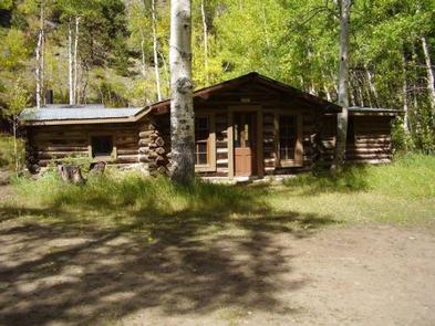
DAWSON CABIN (CO)
Related Link(s)
Colorado State Road Conditions
Overview
Dawson Cabin provides campers with a rustic, remote getaway in the beautiful Clear Creek Canyon. The Clear Creek Historical District offers visitors a taste of mining history from the mid-19th Century, when people came far and wide looking for gold, silver and other precious minerals. By the 1890s, about 50,000 residents lived in the valley, in search of great fortune.
Recreation
Off-road vehicle trails and hiking trails are nearby. Some hiking trails lead into the Collegiate Peaks Wilderness, which is named for the numerous 14,000 ft. peaks named after colleges, such as Yale, Harvard and Princeton.
Collegiate Peaks is the headwaters for the Arkansas, Gunnison, and Roaring Fork Rivers. The landscape is composed of alpine tundra, high lake basins and glacial river valleys.
Facilities
The cabin comfortably fits up to four guests, but two additional guests may fit. Camping outside is permitted as well. Furnishings include a wood burning stove and an indoor picnic table. Guests should bring cots to sleep on, or at least bring a pad to sleep on the floor.
No water or electricity is available. Guests should bring plenty of water. Creek water may be boiled and treated for consumption. Other items to pack include bedding, food, lanterns, matches, cooking utensils, dish soap and a first aid kit. (Click here for more cabin details.)
Natural Features
Dawson Cabin is nestled at the base of Ervin Peak in Clear Creek Canyon, at an elevation of about 9,600 feet. It is on the outskirts of the Collegiate Peaks Wilderness in the Sawatch Range of the Rocky Mountains. Clear Creek passes near the cabin.
The cabin is located in the Leadville Ranger District, which is home to the Sawatch Range, the highest mountain range in Colorado. These rugged, glaciated mountains form the crest of the Continental Divide. Mount Elbert, at 14,443 feet, is Colorado’s highest peak and one of ten "fourteeners" located in the District.
Nearby Attractions
The historic town of Winfield is about 5 miles farther up the valley. The nearest place for pay phones and a grocery store is in Buena Vista, about a 45 minute drive.
Visitors can head to Clear Creek Reservoir, about 5 miles east, for fishing and boating. Fish species include brook trout, brown trout, rainbow trout, and tiger muskie. A few miles further is the Arkansas River, where whitewater rafting is a big hit.