


Directions
Driving Directions: From northeast Tucson, take East Tanque Verde Road to East Catalina Highway. Turn left (north) on East Catalina Highway, which becomes the General Hitchcock Highway, for approximately 23 miles to Organization Ridge Road and turn left (just before Palisades Visitor Center). The cabin is located approximately 100 yards in on the right.
Phone
520-749-8700
Activities
CAMPING, FISHING, HIKING, MOUNTAIN BIKING, ROCK CLIMBING
Keywords
Related Link(s)
Overview
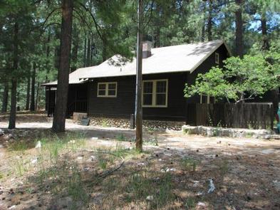
The Palisades Ranger Residence Cabin is located within the Palisades Administrative Site in the Santa Catalina Mountains, 20 miles northeast of Tucson, Arizona. The cabin is reached via the East Catalina Highway, which becomes the General Hitchcock, a historic and scenic drive that takes visitors through multiple biozones from the Sonoran Desert to the dense forests at 8,000 feet elevation. The cabin has indoor plumbing, electricity, a full kitchen, furniture, beds and an enclosed front yard.
Recreation
The Palisades Ranger Residence Cabin is approximately one hour from Tucson, Arizona, and provides excellent access to a myriad of recreational opportunities, including hiking, camping, birding, horseback riding, picnicking, sightseeing, mountain biking, rock climbing, and visiting historic areas. Fishing is also available at nearby Rose Canyon Lake. Winter sports are available at higher elevations, depending on snowfall; Mt. Lemmon Ski Valley in the Santa Catalina Mountains is the southernmost ski area in the United States.
Facilities
The Palisades Ranger Residence is a five room cabin, suitable for up to four people. The cabin consists of a bedroom, dining room, living room, bathroom, and fully-equipped kitchen. The bedroom has a twin-over-double bunkbed, while the living room contains a queen-size futon. The dining room has a table and four chairs. The kitchen is equipped with a propane stove/oven, microwave, refrigerator, pots, pans, utensils, dishes, and a coffee pot. The house has electricty, a propane heater, and running water. While the cabin has amenities for comfortable lodging, guests do need to provide some of their own supplies, including food, sleeping bags, linens, pillows, towels, dish soap, matches, a first aid kit, toilet paper and garbage bags. Although electricity is available, it is recommended that guests bring an additional light source in case of emergencies.
Natural Features
The Santa Catalina Mountains comprise one of the “sky islands” in the Coronado National Forest. From the desert floor to the upper slopes of Mt. Lemmon, biozones vary from Sonoran desert to subalpine forest, with wildlife communities that are equally diverse. An extensive trail network offers opportunities for day and extended trips, with easy access to the nearby Pusch Ridge Wilderness.
Nearby Attractions
Numerous attractions are also available nearby, including: the Sky Island Scenic Byway (General Hitchcock Highway), Rose Canyon Lake, Mt Lemmon Ski Valley, The University of Arizona Mt. Lemmon Sky Center, the hamlet of Summerhaven, Arizona, as well as numerous hiking trails, and opportunities for photography and picnicing. Attractions within one hour’s drive include Sabino Canyon Recreation Area and Saguaro National Park East.